Traditionally at RIEGL, there will again be a large number of innovations and further developments in all areas at the RIEGL booth. Come visit us to explore new features, enhanced sensor performances, and system capabilities in all segments, from terrestrial, to mobile and airborne.
A special focus will be the launch of three new products – all related to the airborne sector proving: RIEGL is “Ready for Take Off” as an innovator in the surveying industry, again!
RIEGL VQX-2 – Helicopter Pod for Airborne Surveying
With the new RIEGL VQX-2 helicopter pod, RIEGL expands its range of user-friendly complete solutions for airborne data acquisition. The extremely lightweight yet robust pod can be quickly and easily mounted and demounted. The pod integrates a RIEGL laser scanner, a high-performance IMU/GNSS unit, and up to 5 cameras. The choice of the RIEGL laser scanner type – as well as the number and orientation of the cameras – can optimally take into account the requirements of the respective mission tasks, from corridor mapping, to surveying large areas from high altitudes, to monitoring glaciers and landslides. The turnkey solution is offered including the corresponding cabling; a “Minor Change Approval” is already available for Airbus Helicopters AS350 series helicopters. More info: RIEGL VQX-2
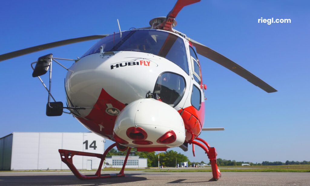
RIEGL VQX-2 Helicopter Pod: lightweight and compact pod with scanner, IMU/GNSS unit und cameras fully integrated.
RIEGL VQ-680 OEM – Airborne LiDAR Scanning Module for OEM Integration
With the new VQ-680 OEM, RIEGL provides system integrators with a compact airborne LiDAR scanner module designed for the integration with large-format cameras or other sensors in complex hybrid system solutions. The form factor is optimized to provide a compact scanner with a small exit aperture, and considers the limited space in, e.g., large-format photogrammetric cameras systems.
A sturdy mechanical interface enables mounting the LiDAR module inside a camera system rigidly connected with the IMU/GNSS system and various camera modules.
The LiDAR scanner module with laser pulse repetition rates of up to 2.4 MHz and up to 2 million measurements/sec. has been specifically designed for large-scale applications in urban mapping, forestry and power line surveying. Its wide field of view of 60 degrees and RIEGL’s NFB (Nadir/Forward/Backward) scanning, that offers five scan directions up to ± 20 degrees, enable exceptional coverage of vertical structures such as building facades or power poles at high accuracy. At the same time, the laser beam directed to the nadir captures scan data from the bottom of even narrow street canyons with only the slightest shadowing caused by surrounding buildings.
The operational envelope ranges from typical flying altitudes of 1000 m AGL at a pulse repetition rate of 2.4 MHz (~ 24 pts/m2 at 120 kts), up to 2300 m AGL at a PRR of 300 kHz for targets with reflectivity in excess of 20%. This makes the VQ-680-OEM to an efficient tool for service providers in the airborne mapping sector.
Besides this module for OEM integrators, the sister type RIEGL VQ-680 is offered as High-end Airborne LiDAR Scanner providing the full range of performance in a compact and light-weight scanner housing. This scanner allows the combination with up to six high-resolution RGB/NIR cameras and an easy mounting in appropriate aircraft hatches with or without using stabilized platforms.
More information: RIEGL VQ-680 OEM and RIEGL VQ-680
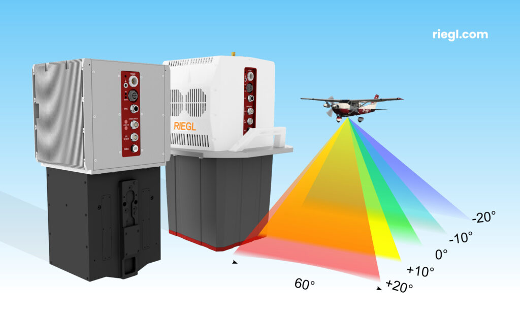
RIEGL VQ-680 OEM Airborne LiDAR Scanner Module and RIEGL VQ-680 Airborne Laser Scanner: NFB (Nadir/Forward/Backward) scanning for exceptional coverage of vertical structures.
RIEGL VUX-180-24 – lightweight and versatile UAV LiDAR Sensor for High-Speed Surveying Missions
The new RIEGL VUX-180-24 offers a wide field of view of 75 degrees and an extremely high pulse repetition rate of up to 2.4 MHz. These features – in combination with an increased scan speed of up to 800 lines per second – make it perfectly suited for high-speed surveying missions and applications where an optimal line and point distribution is required. Typical applications include mapping and monitoring of critical infrastructure like power lines, railway tracks, pipelines, and runways. The RIEGL VUX-180-24 provides mechanical and electrical interfaces for IMU/GNSS integration and up to 5 external cameras. For smooth and straight forward data storage, an internal SSD memory with 2 TByte storage capacity and a removable CFast memory card are available.
This sensor further complements RIEGL’s already proven VUX-120, VU-160, and VUX-240 series and is available as stand-alone sensor or in various fully integrated laser scanning system configurations with IMU/GNSS system and optional cameras.
More information: RIEGL VUX-180-24
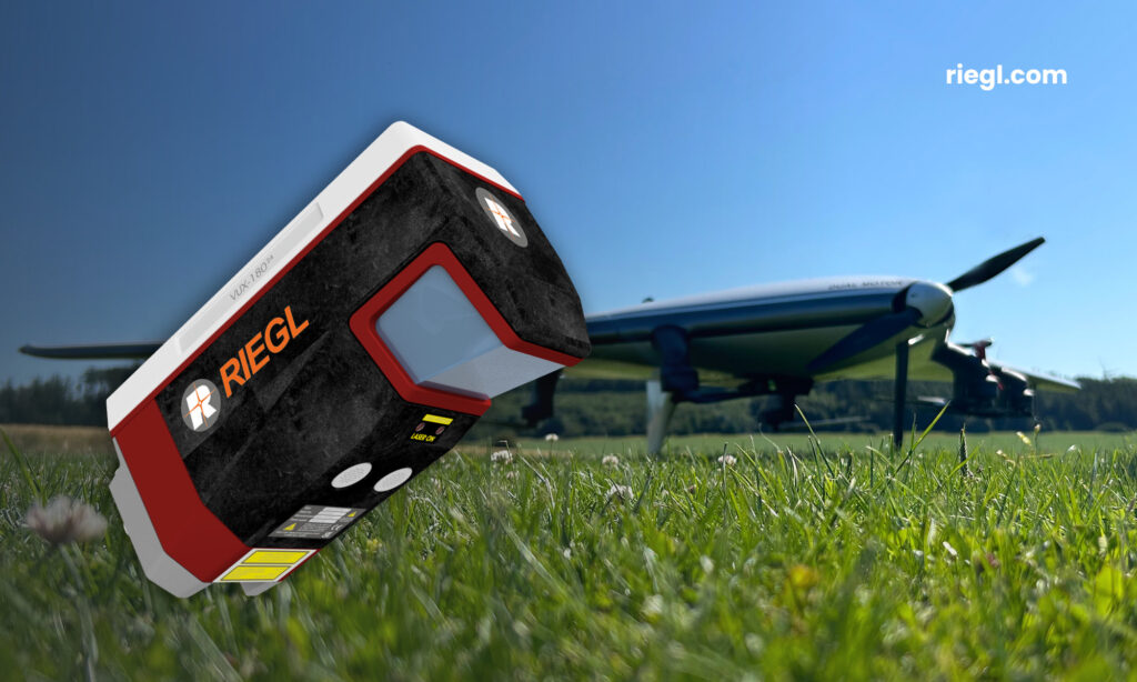
RIEGL VUX-180-24: lightweight and versatile UAV LiDAR Sensor for High-Speed Corridor Mapping.
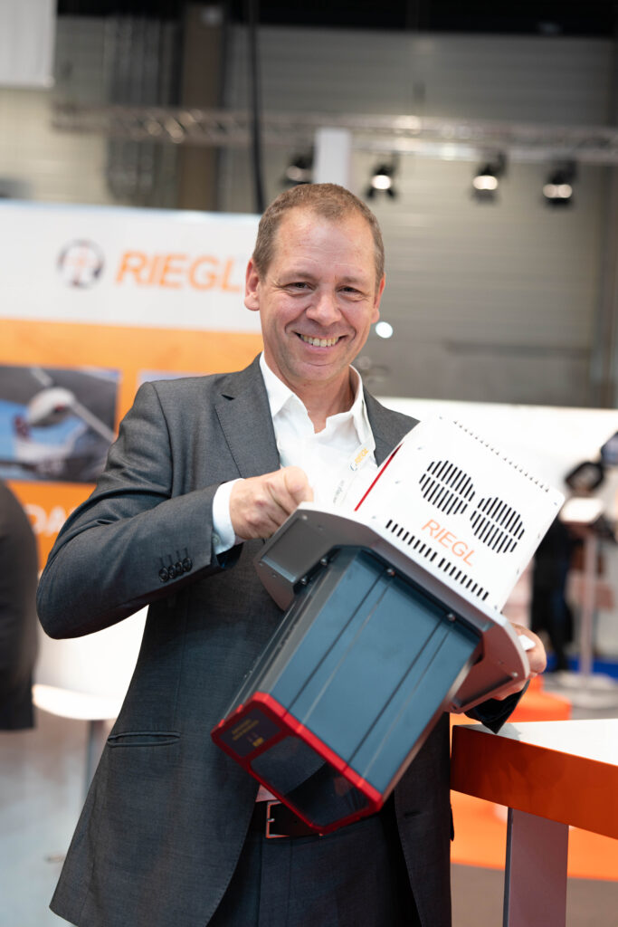
Peter Rieger, RIEGL Airborne Laser Scanning Business Division Manager, proudly presenting the new RIEGL VQ-680 Airborne Laser Scanner.
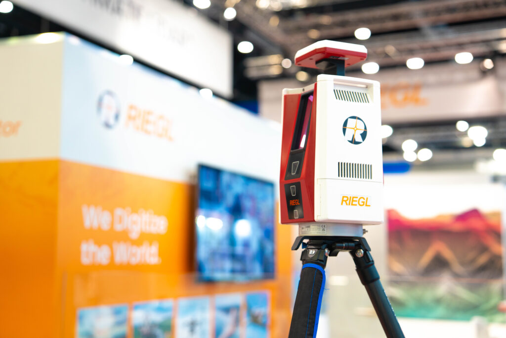
Again, a real highlight at the RIEGL Intergeo booth: The VZ-600i 3D Terrestrial Laser Scanner with some new impressive features.
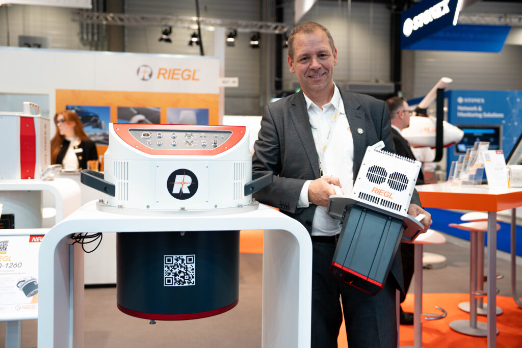
RIEGL’s portfolio for airborne laser scanning has been further expanded: In addition to the large-format systems like the VQ-1260, now the new VQ-680 with NFB (Nadir/Forward/Backward) scanning capability is available for mapping of complex urban environments.
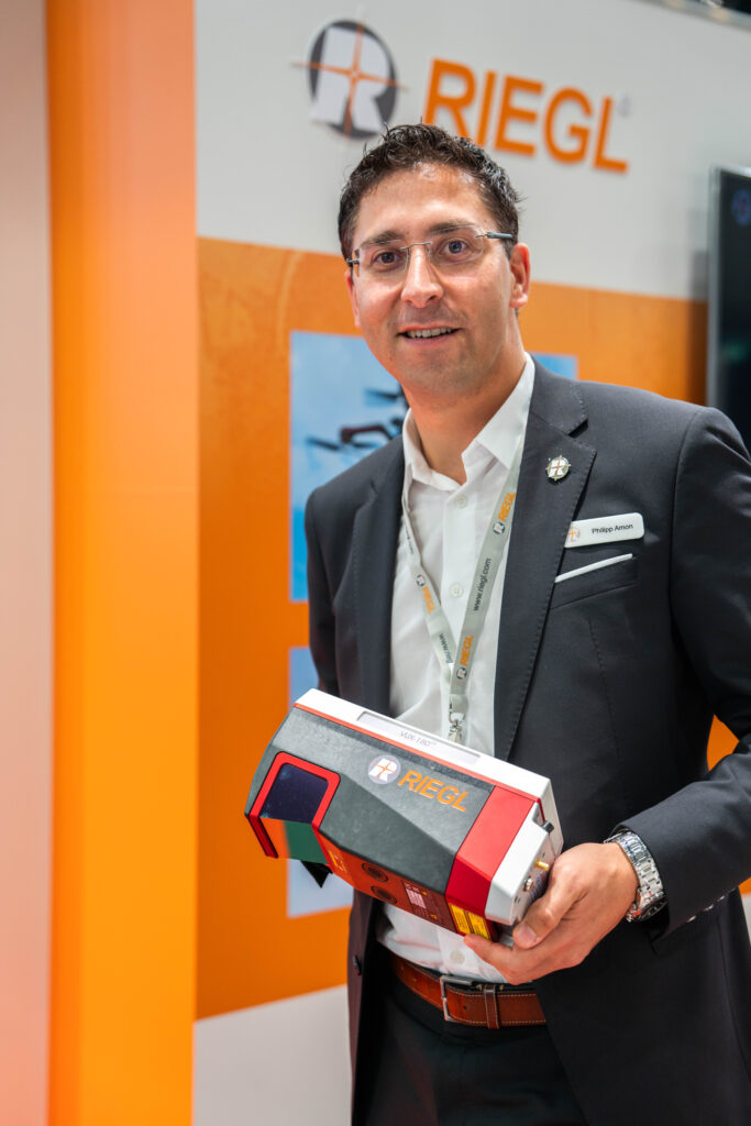
Philipp Amon, RIEGL UAV-based Laser Scanning Business Division Manager, with the new RIEGL VUX-180-24 UAV LiDAR Sensor for High-Speed Surveying Missions.
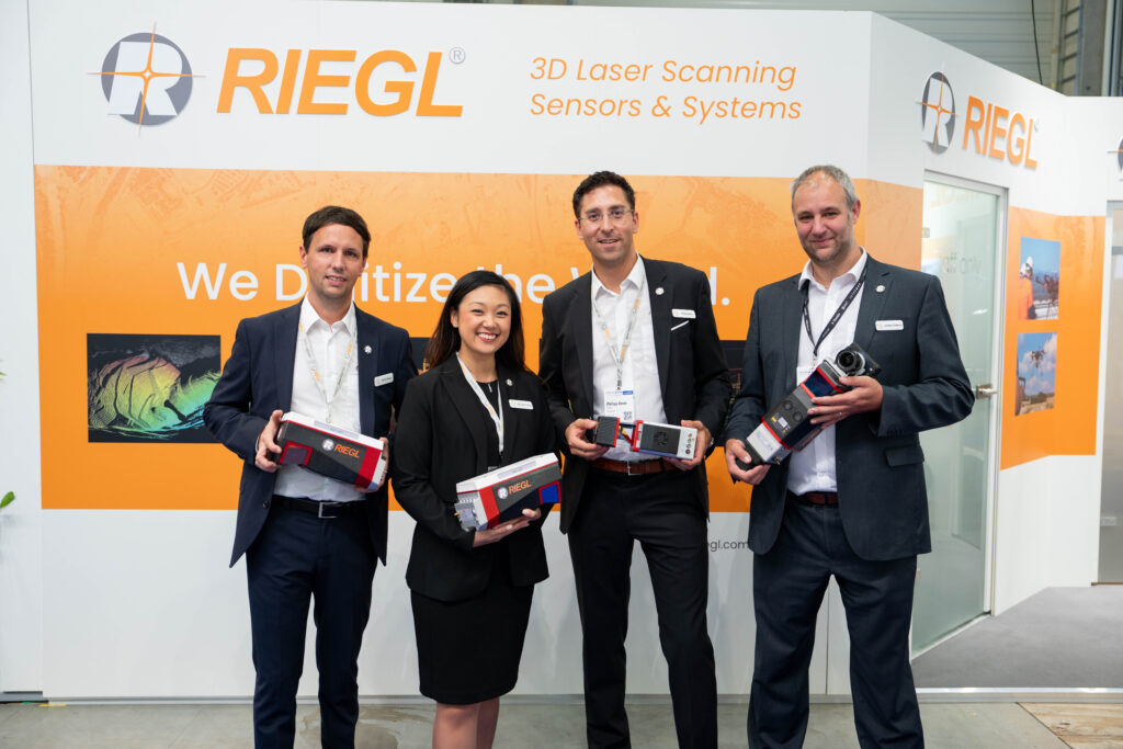
The worldwide RIEGL ULS (UAV-based Laser Scanning) Team proudly presenting the latest developments in the portfolio of UAV LiDAR sensors and systems.
