We would always tease hydrogeologist colleagues that in southwest Florida there are probably 1000 types of rocks, 999 of which are limestone, because, whenever geologists would drill a well into the earth, they identified hundreds of differently named rocks in the cores, but these are all just names for different limestones. This limestone, dissolved away over the past several thousand years, resulted in the karst geology that gives rise to sinkholes and springs throughout the state. This springshed system also forms the hydrological heart of the peninsula of Florida, the Green Swamp. Four major rivers incise the peninsula of Florida: the Hillsborough, Ocklawaha, Peace and Withlacoochee. All have their headwaters in and around the Green Swamp.
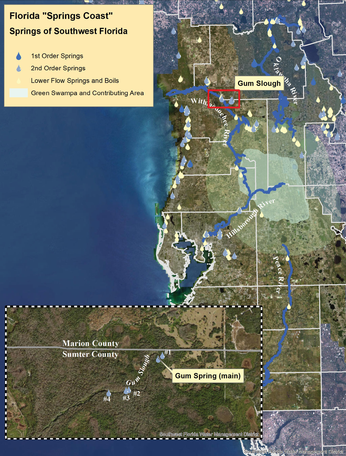
Figure 1: The “Springs Coast” of southwest Florida showing higher order springs and boils. The inset map shows the four USGS numbered springs in addition to the “main” spring that contribute flow to Gum Slough.
The Florida Geological Survey (FGS) has been mapping the extensive distribution of springs in Florida for over 25 years and, in 2003, published Special Publication No 52,—Florida Spring Classification System and Spring Glossary1 and a map of the first order springsheds2. Since then, the US Geological Survey (USGS) has recognized 27 1st magnitude (≥100 ft3/s average flow) springs in Florida, seven of which are found in the region surrounding the Green Swamp3. There are many more 2nd and 3rd magnitude springs. These smaller springs, with lower average flow, are often difficult to locate either because they occur in remote, difficult to reach, densely forested bottomlands, or they emerge as underwater boils in bays and shallow coastal waters. Although locating underwater boils was not the purpose, a 2015 topobathymetric lidar survey using a Coastal Zone Mapping and Imaging Lidar (CZMIL) topobathymetric lidar system in Kings Bay/Crystal River on the Springs Coast revealed the location of several likely unknown 2nd and 3rd order springs4. Thus, we suspected that additional topobathymetric surveys of inland Springs Coast waterways would similarly reveal previously unknown springs.
In the winter of 2021, when Dewberry acquired a Teledyne Geospatial CZMIL Nova topobathymetric lidar sensor, several test flights were conducted in the Tampa Bay area. In part as a proof-of-concept demonstration and in part to assist the Southwest Florida Water Management District (SWFWMD), Dewberry mapped a spring run, Gum Slough, on the Sumter/Marion County border (Figure 1).
Gum Slough runs for approximately 7.4 km (about 4.6 miles) from the main springhead to the confluence with the Withlacoochee River, through dense bottomland vegetation. The only access to the run is near the primary springhead, through gated, privately owned property. The nearest county road is over 2.5 km away! From the FGS and USGS mapping surveys, five feeds contributing to 2nd order springs, the main springhead and four auxiliary springs (Figure 2), were known to contribute to the flow in the slough. Indeed, USGS installed a water-level gauge at the junction of Gum Slough and the channel of the Withlacoochee River5, which is monitored by SWFWMD.
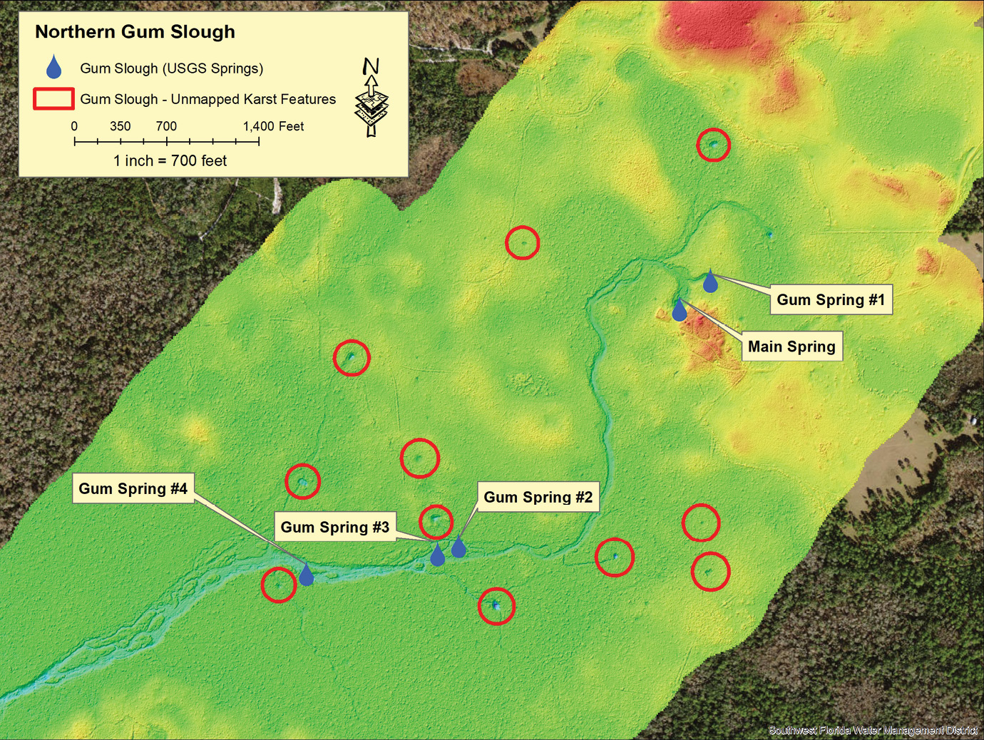
Figure 2: Northern portion of Gum Slough showing the five feeds contributing to 2nd magnitude springs mapped by USGS. The red circles are areas of at least 11 new, potential karst features, sinks or springs, which were revealed in the CZMIL topobathymetric lidar data. In addition to the unmapped karst features, the CZMIL data revealed the braided nature of the slough.
Flight mission and data processing
Dewberry flew a Teledyne Geospatial CZMIL Nova sensor over the Gum Slough area of interest (AOI) on 5 February 2021. The AOI consisted of 14 5000’ x 5000’ tiles referenced to the Florida Statewide State Plane West Tiling System6, completely surveying approximately 7.5 km (4.6 linear miles) of the spring run. The mission was designed to meet or exceed the density (≥2.0 ppsm) and accuracy requirements (10 cm RMSeZ) for National Coastal Mapping Strategy 1.0 QL2b standard7. The point density and accuracy, 5 ppsm, and 3.87 cm RMSeZ (on non-vegetated terrain) respectively, exceeded the specification.
Bathymetric lidar data must have a refraction correction applied, which adjusts the horizontal and vertical (depth) positions of each data point by accounting for the change in direction and speed of light as the laser pulse enters and travels through water. The refraction correction was performed by Dewberry using the Dewberry Lidar Processor (DLP) tool.
The refraction tool uses a modeled water surface and mission-smoothed best estimate of trajectory (SBET) data to correct the ranging and horizontal placement of all green (i.e. collected with 532 nm laser) lidar points initially classified as water column. The initial water column classification is based on breakline placement. The refraction tool creates a new output data file and does not modify the input files.
After data calibration and refraction, Dewberry used CARIS™ and TerraScan™ software for processing. The raw point clouds were imported into CARIS for conversion to LAS format and output with an initial classification schema based on stored sensor data. The LAS files were tiled according to the project tile grid. Once tiled, the laser points were classified using a proprietary routine in TerraScan, which classified obvious low outliers in the dataset to class 7 and high outliers to class 18. Points along flight line edges that were geometrically unusable were flagged as overlap and allocated to a separate class so that they would be excluded from the initial ground algorithm. After points that could negatively affect the ground were removed from class 1, the ground layer was extracted from this remaining point cloud using an iterative surface model.
Following the initial automated ground routine, each tile was imported into TerraScan and a surface model created. Dewberry analysts visually reviewed the topobathymetric surface model and corrected errors in the ground classification such as vegetation, buildings, bridges, and grounded water column or surfaces that were in ground classes following the initial processing. Analysts also looked for features that were present in the point cloud but not reflected in the ground model, including obstacles to marine navigation. The final point-cloud classification is shown in Table 1.
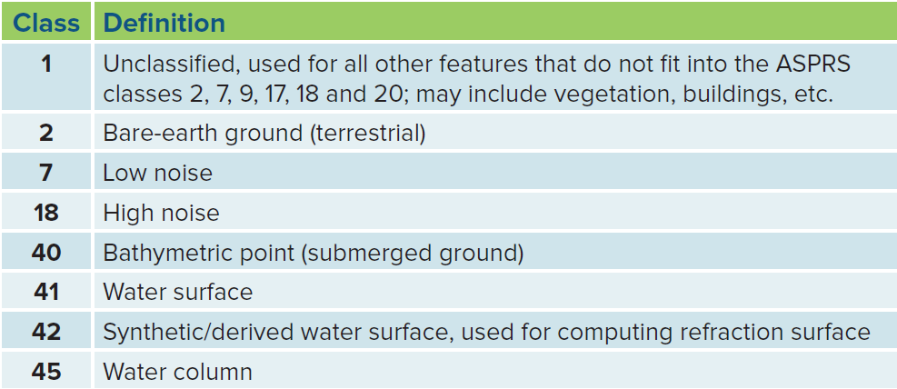
Table 1: ASPRS classification scheme with definitions used for Gum Slough topobathymetric lidar.
All data delivered to SWFWMD were formatted to ASPRS LAS 1.4 Point Data Record Format 6, referenced to the Florida State Plane West, NAD 1983/2011, NAVD88 (Geoid 2018) in US feet.
Field verification

Figure 3: Northern Gum Slough showing the locations of four SWFWMD field-verified newly discovered springheads. The asterisk (*) by the spring name refers to the ground-level photographs in Figure 4.
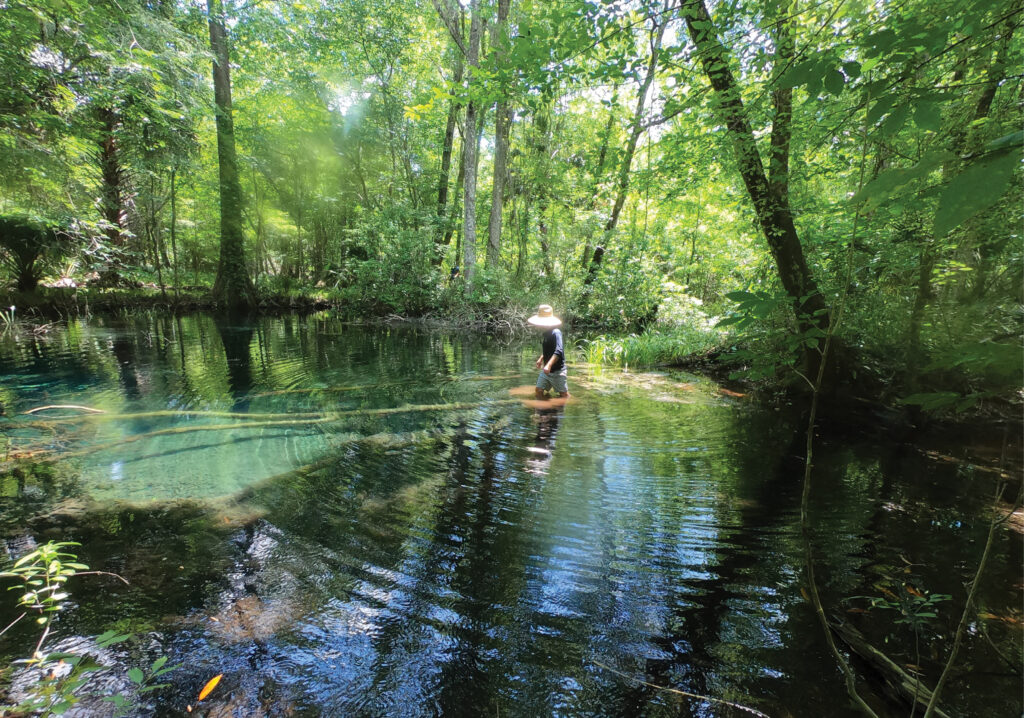
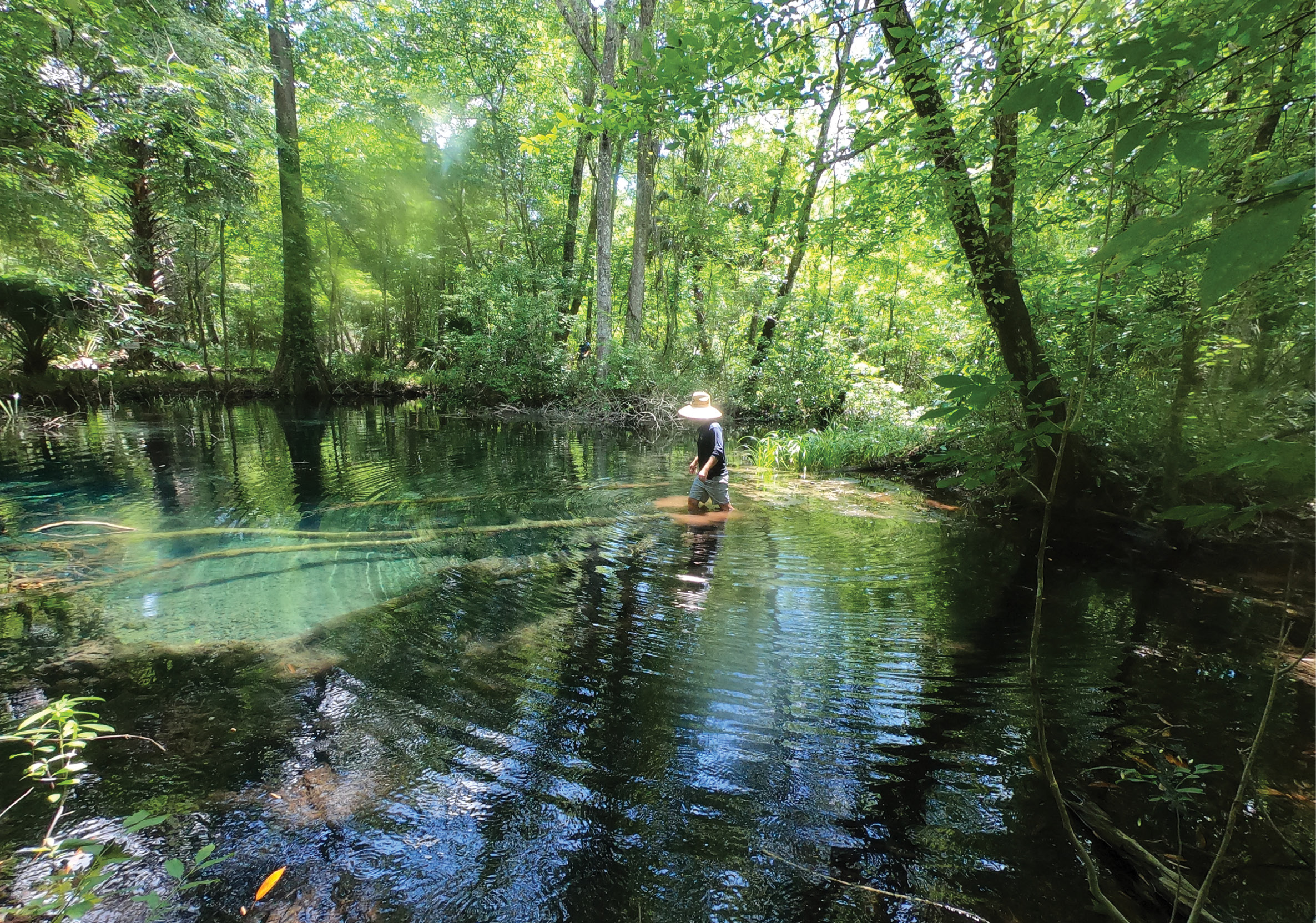
On 17 May 2022, a SWFWMD team deployed, over land on foot, to field-verify the locations of several of the karst features revealed by the CZMIL data. They confirmed the springhead locations for four springs later that summer8. The team visited four of the 11 potential new springhead sites (Figure 3). The team verified and inspected the four sites, identified the spring outlet (on subsequent visits) and recorded a GNSS position for each new spring. The four newly discovered springheads now have SWFWMD-recorded names of (from north to south) Hidden Spring (Figure 4 top), Butches Spring, DeWitt Spring and Rogers Spring (Figure 4 bottom).
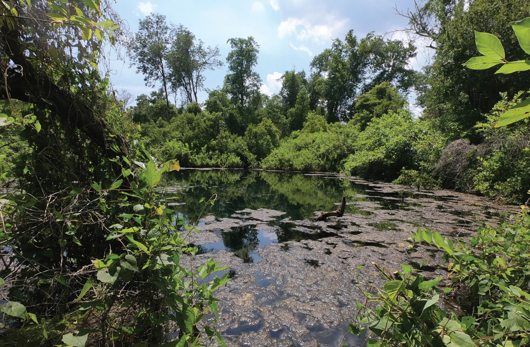
Figure 4: Hidden Springs (top) and Rogers Spring (bottom). Photographs from the SWFWMD field verification visit on 17 May 2022.
Conclusions
Natural springs are major contributors to flow in the waterways of Florida. The water management districts must be able to identify those potential flow inputs and parameters in natural systems, so accurately mapping the springs is paramount. In dense vegetation, which precludes aerial photography as a tool to map those springs, other methods need to be employed.
The CZMIL Nova topobathymetric sensor was used to map the floodplain and the course of Gum Slough. While the major springheads were known and mapped by FGS and USGS, the CZMIL Nova survey revealed the locations of at least 11 previously unidentified “karst features” in an economical survey. Following SWFWMD field verification, it appears that topobathymetric lidar data is reliable and easily interpretable and can be used to locate additional karst features, such as sinkholes and springheads, through the dense vegetation found in the swamps, floodplains and wetlands of Florida.
Acknowledgements
We would like to acknowledge all of the support that this project received from both the SWFWMD Bureau of Natural Systems and Restoration and the bathymetric lidar team at Dewberry. This project originated as a test flight that developed into a fully calibrated survey. The SWFWMD Environmental Flows and Levels section sweltered through the summer heat to field-verify the locations of potential springheads as mapped by the CZMIL Nova.
 Alvan “Al” Karlin, Ph.D, CMS-l, GISP is a senior geospatial scientist at Dewberry, formerly from the Southwest Water Management District (SWFWMD). While at SWFWMD he managed all of the remote sensing and lidar-related projects in mapping and GIS. With Dewberry, he serves as a consultant on Florida-related lidar and imagery projects, as well as general GIS-related projects. He has a Ph.D in computational theoretical genetics from Miami University in Ohio. He is a Director on the Board of the Florida Region of ASPRS, an ASPRS Certified Mapping Scientist—Lidar, and a GIS Certification Institute Professional.
 Danielle Rogers, PWS, PMP is an Environmental Project Manager in the Natural Systems and Restoration Bureau at SWFWMD. She has worked for the District for 17 years and is a professional wetland scientist and project management professional. Prior to joining the District, she worked as an environmental specialist for the Florida Department of Environmental Protection and as a project technician in the private sector. Her experience is in coastal and lotic ecosystems, springs ecology, geographical information systems spatial analysis, mobile mapping technology and geospatial model development. She earned a master’s degree in Marine Affairs from the University of Miami, Rosenstiel School of Marine and Atmospheric Science. Her program focused heavily on understanding cumulative and secondary impacts in ecosystems, coastal law and translating scientific information into policy.
 Emily Klipp is a project manager with Dewberry and has more than 15 years of experience working with topographic and topobathymetric lidar data. She specializes in geospatial project planning and management, QA/QC of topographic and bathymetric data, vertical and horizontal accuracy assessments, and creation of a variety of digital mapping products using various software platforms. Emily has led topobathymetric and topographic lidar projects for USGS, NOAA, USFWS, and SWFWMD. Emily is a member of ASPRS and has presented reports at several ASPRS annual meetings and Geo Week conferences, as well as other professional meeting venues. From 2007 to 2014, she authored more than 35 data series and reports for USGS and helped manage operations and data production of the NASA/USGS EAARL sensor for the USGS Coastal Program.
4 Kalvin, A., A. Nayegandhi and J.F. Owens, 2017. Topo-bathymetric lidar on the Springs Coast of Florida, LIDAR Magazine, 7(4): 36-43, June 2017.