FL-ASPRS/UF FALL 2022
Virtual Lidar Workshop
The Florida Region of the American Society for Photogrammetry and Remote Sensing (FL-ASPRS) and the University of Florida Geomatics Division have been hosting bi-annual “Lidar Workshops” since spring 2016. The Fall 2022 workshop was held at the Mid-Florida Research & Education Center of the University of Florida’s Institute of Food and Agricultural Sciences at Lake Apopka on 17 November 2022. The workshops are open to ASPRS members and non-members alike, for either in-person or virtual participation. The Fall 2022 Workshop hosted 75 on-site participants and 255 virtual attendees.
The UF/FL-ASPRS workshops serve as both a bi-annual FL-ASPRS Region meeting and as educational outreach to the general photogrammetry and remote sensing community. With respect to the ASPRS mission statement, “to promote a balanced representation of the interests of government, academia and private enterprise”1, the program focuses on these three sectors with presentation sessions devoted to each. Below is an outline of the sessions with synopses of each.
Session 1: State and Federal Updates
The State and Federal Updates generally start with updates from the five Water Management Districts in Florida. However, as the two major lidar projects resulting from Recovery funding for Hurricane Irma (the peninsula of Florida) and Hurricane Michael (most of the panhandle of Florida) are concluding, there were no Water Management District project updates.
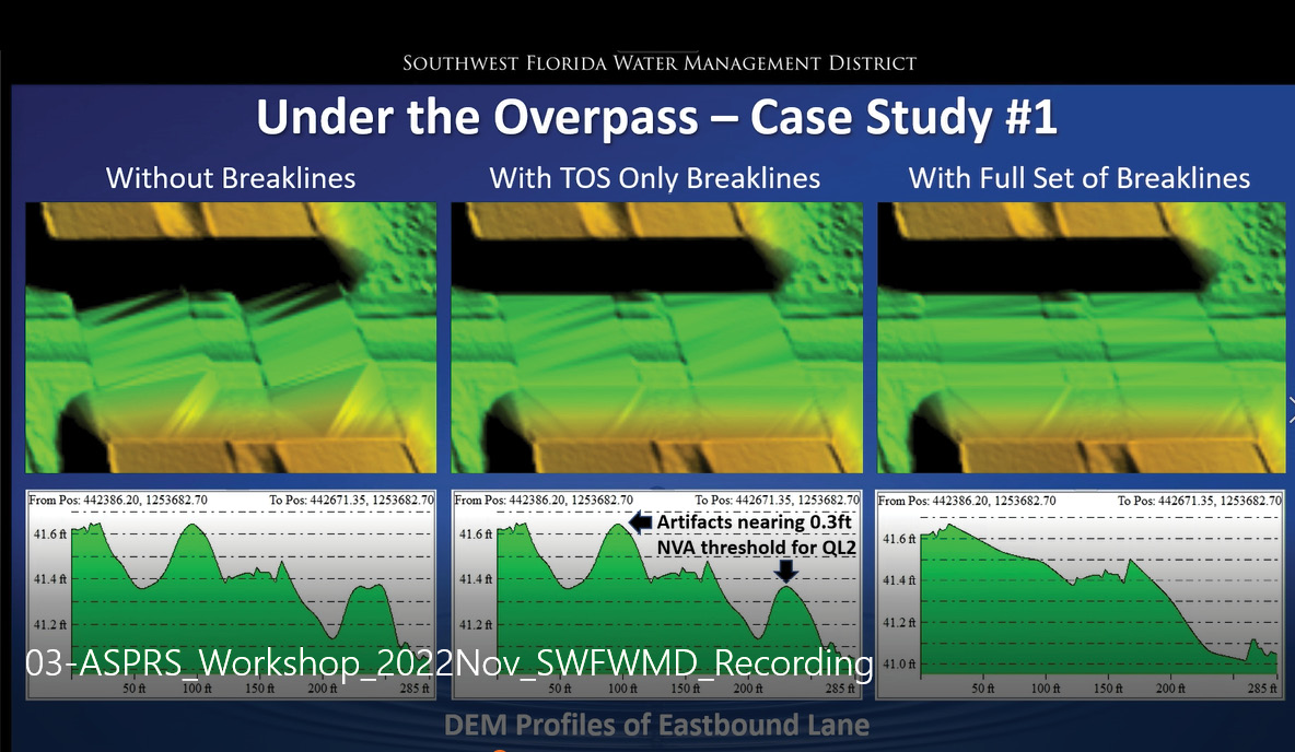
Figure 1: Digital elevation model overpass interpolation issues arising from lidar data voids. Standard Breaklines at the Toe of Slope (TOS) do not significantly improve the DEM as compared to no breaklines. However, a full set of breaklines that also includes the centerline and edges of pavement produces an accurate ground surface for water flow.
Southwest Florida Water Management District: Nicole Hewitt used the timeslot to discuss the importance of (1) accounting for lidar data voids resulting from water and anthropogenic structures, and (2) the need for accurate breaklining in the construction of digital elevation models (DEMs) that are to be used for surface water modeling. Nicole began by describing the interpolation issues that arise when waterbodies are not properly interpolated into the DEM. Then, she detailed two scenarios where the “standard” USGS 3DEP breaklines are not sufficient to produce proper surface water flow, emphasizing the importance of correct breakline placement for bridges and overpasses (Figure 1).
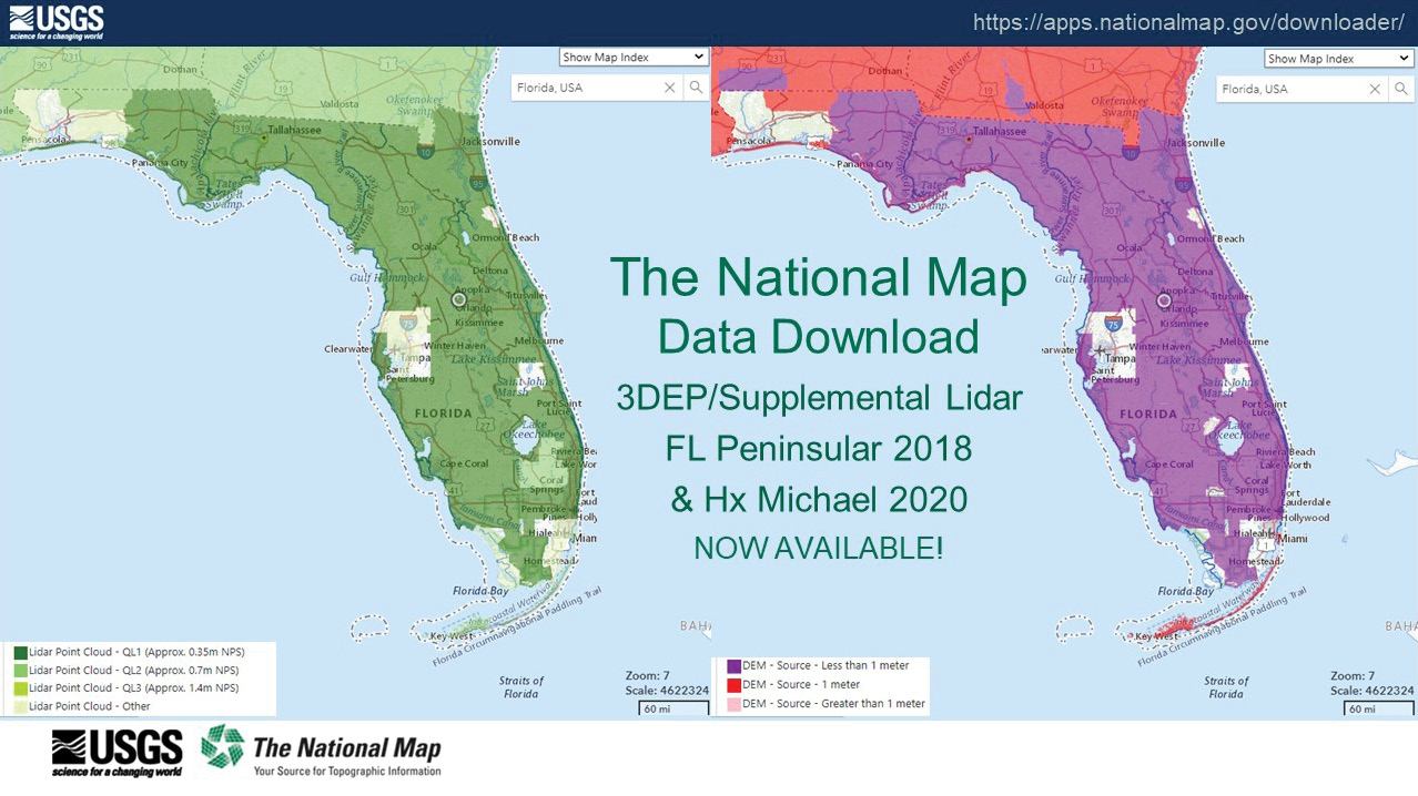
Figure 2: The National Map Data Download, recently updated by USGS, showing the Florida Peninsular and Hurricane Michael lidar data.
U.S.Geological Survey: Alexandra (Xan) Fredericks, the USGS National Map Liaison assigned to Florida, presented an update to the Florida lidar data available on The National Map, showing that the entire FL Peninsular 2018 and the Hurricane Michael 2020 data are currently available (Figure 2).
Xan continued to discuss the 3D Nation Vision and the 3D National Topography Model (3DNTM). She presented a brief summary of some of the results of the recently released 3D Nation Elevation Requirements & Benefits Study. She concluded by noting the importance of collaboration and presented a map showing the names of the USGS National Map Liaisons (usgs.gov/ngp-user-engagement-office).
Florida Coastal Mapping Program (FCMaP): Dr. Cheryl Hapke, University of South Florida College of Marine Science, discussed the evolving mission of the Florida Coastal Mapping Program. Started in 2017 as a steering committee to identify statewide needs in coastal mapping and conduct a gap analysis of existing coastal seafloor data, followed by a statewide stakeholder prioritization study, this is now solidifying its five-year strategic plan. In place of the steering committee, a FCMaP Science and Technical Advisory Council was stood up, composed of the same membership as the steering committee, but with distinct terms of reference to distinguish FCMaP (a coordinating body) from the Florida Seafloor Mapping Initiative (data collection funded by the Florida Department of Environmental Protection (FDEP)). Cheryl presented a draft of the FCMaP 5-year Strategic Plan (Figure 3).

Figure 3: Draft FCMaP 5-year Strategic Plan as presented at the Workshop.
She concluded her presentation by emphasizing the need for coordination across a diverse portfolio and engagement by both organizations and individual stakeholders, to make the Florida Seafloor Mapping Initiative successful.
NASA-Jet Propulsion Laboratory: Dr. Batu Osmanoglu provided the update on the NISAR launch dates and Community of Practice. He was happy to inform the Workshop that the much-anticipated launch for the NISAR satellite is scheduled for 29 January 2024. He provided some additional information on test data available to early adopters, as well as potential data products with schedules. He briefly discussed the recent NISAR Science Community Workshop in Pasadena, California, where over 290 people participated. Batu ended his presentation with information on how to join the Early Adopters and Community of Practice (Figure 4).
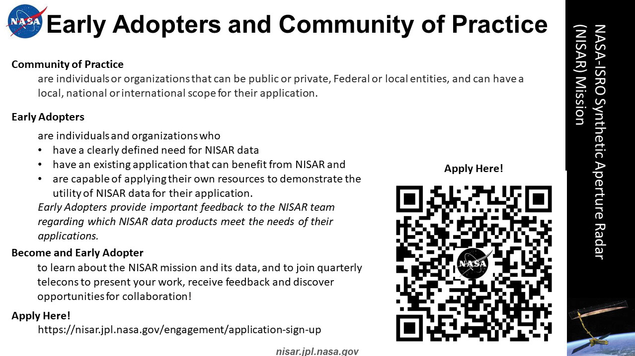
Figure 4: Web-link and QR Code for joining the NISAR Early Adopters and Community of Practice.
National Oceanic and Atmospheric Administration (NOAA): NOAA is currently conducting two large-area topobathymetric lidar mapping projects in Florida, one focused on mapping over 615 square miles of the Indian River Lagoon with the St. Johns River Water Management District (SJRWMD) and FDEP as partners, and the other focused on mapping approximately 1373 square miles in the Big Bend Region on the Gulf Coast of Florida.
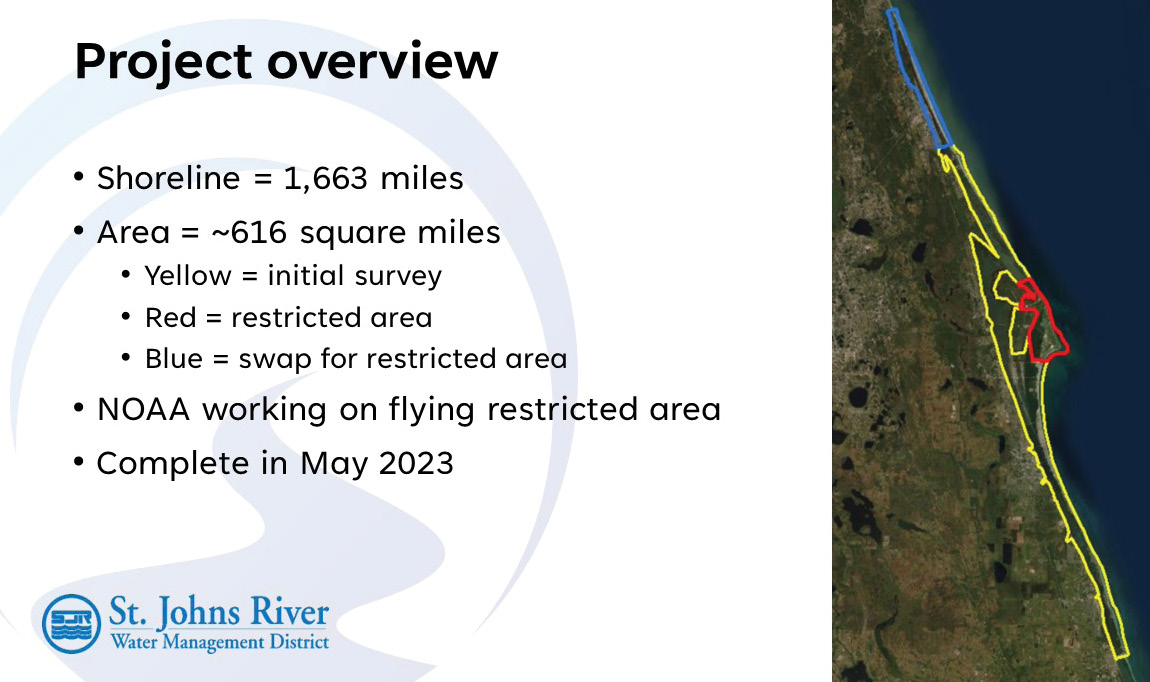
Figure 5: Overview of the NOAA/SJRWMD/FDEP Indian River Lagoon topobathymetric lidar and imagery mapping project.
Indian River Lagoon (IRL): Dr. Charles Jacoby representing SJRWMD provided the update on this project. He started by noting several of the issues surrounding the bathymetry of IRL, specifically the loss of seagrass, the unstable sediments and how the bathymetry affects management decisions. The project includes topobathymetric lidar and digital imagery for approximately 1663 miles of shoreline in an area of approximately 616 square miles (Figure 5). He noted that although most of the lidar was collected using a Teledyne Geospatial CZMIL sensor, the restricted area around Cape Canaveral Space Force Station would be collected with a NOAA RIEGL 880G sensor. The project is scheduled for completion in May 2023.
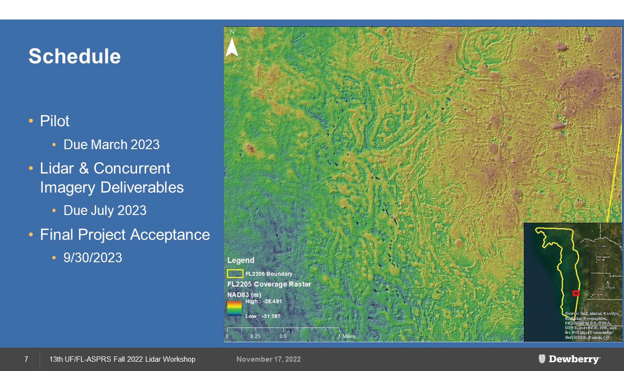
Figure 6: Topobathymetric DEM showing bathymetry of an area recently collected in the Big Bend area of Florida.
Tampa Bay and Big Bend: Emily Klipp from Dewberry provided the update on two Gulf Coast of Florida NOAA topobathymetric lidar projects (Figure 6). Northern Tampa Bay (FY2020) was mapped using the RIEGL 880G sensor and Southern Tampa Bay (FY2021) was mapped with a Teledyne Geospatial CZMIL sensor. Both projects are now complete and the data are available on the NOAA Digital Coast (coast.noaa.gov/digitalcoast/). She continued to highlight the NOAA/Big Bend, approximately 1,373 square mile, topobathymetric lidar mapping that is currently underway. Dewberry is using a Teledyne Geospatial CZMIL SuperNova for this mapping. She highlighted the Customer Data Portal and Dashboard that were constructed to permit daily updates on the project’s progress.She concluded by showing the DEM for an area recently collected (Figure 6). The project is scheduled to be completed by the end of September 2023.
Session 2: Keynote Address—Brett C. Wood: Geospatial mapping and data management at FDOT
Each workshop includes an invited “Keynote Speaker.” Brett Wood is the State Surveyor for the Florida Department of Transportation (FDOT) and manages the Central Surveying and Mapping Office (CSMO) located in Tallahassee. Brett has over 39 years’ experience in surveying and mapping and became a Licensed Surveyor and Mapper in 1997. Prior to this he served as Mobile Surveying & Mapping Manager within the CSMO. Brett came to the Department in 2009 from the private sector, specializing in GNSS and remote sensing technologies.
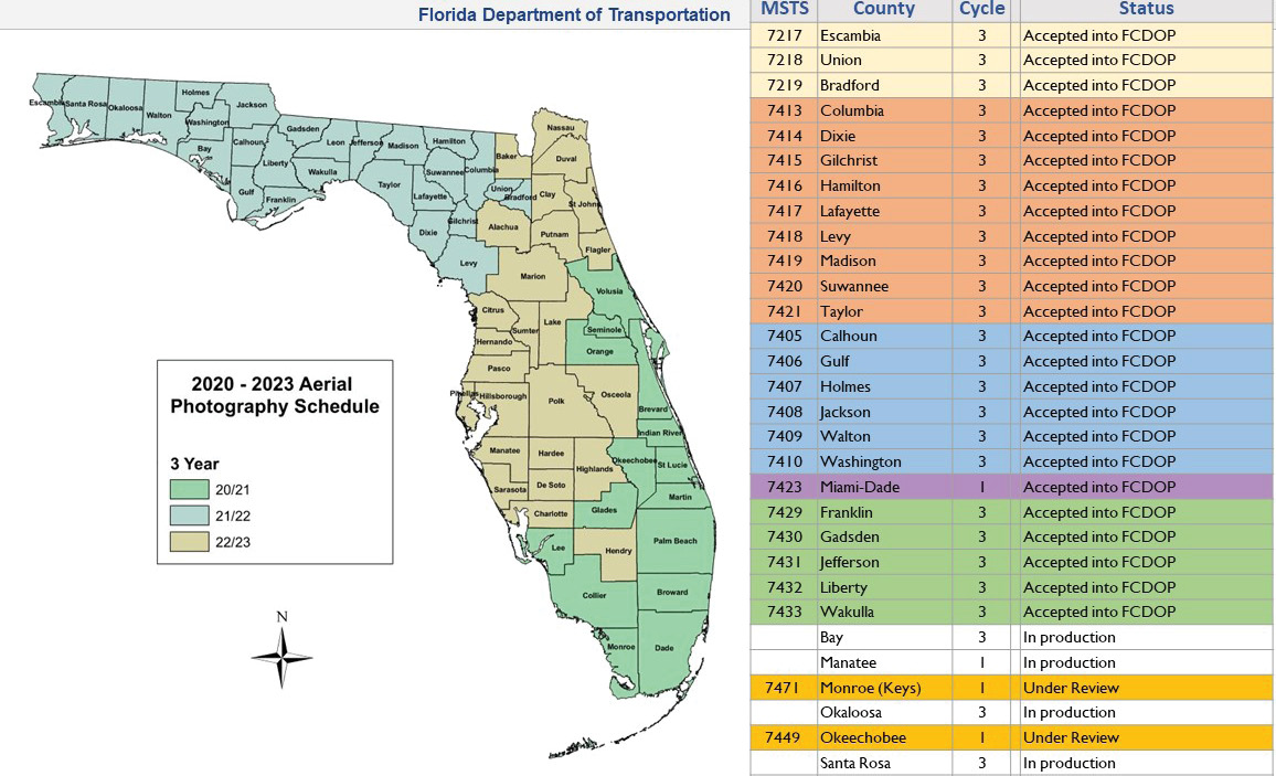
Figure 7: FDOT three-year rotating aerial survey of Florida.
Brett opened his presentation by describing the administrative structure of FDOT and its historical role in state topographic mapping. Florida was one of the early adopters of aerial mapping and has been using photogrammetry since 1949. FDOT is responsible, under Florida Statute 373.012, for topographic mapping. Starting by conducting the aerial surveys in-house using state-owned film-based metric cameras, then moving to digital cameras in the early 2000s, FDOT has a long history in remote sensing. By 2014, CSMO had shifted direction by employing mobile mapping technologies and outsourcing aerial surveying and mapping services to the consultant community. FDOT is currently working with the Florida Division of Revenue to conduct aerial orthophotography of the entire state on a three-year rotating schedule (Figure 7).

Figure 8: The changing role of the Central Surveying and Mapping Office at the Florida Department of Transportation.
Brett went on to discuss FDOT’s methods and procedures for quantifying the accuracy of 3DEP lidar for use in roadway surveying. He concluded his presentation by discussing the Florida Permanent Reference Network (FPRN) and the evolving role of CSMO (Figure 8).
Session 3: The Florida Seafloor Mapping Initiative (FSMI)—Topobathymetric Workshop
In 2021, $100M was provided to FDEP to capture statewide bathymetric data. The intent of the project is to capture topobathymetric lidar, to the greatest extent possible in the 0–20 m depth range, and then use acoustic technologies to map in the 20-200 m range. FDEP’s Office of Resilience and Coastal Protection (ORCP) was charged with the management and coordination of the project.
In mid-2022 ORCP solicited a Response for Proposals/Qualifications to perform the mapping and selected five consulting firms for the project. As each firm brings a unique suite of qualifications to the project, the FL-ASPRS Board of Directors invited a representative from each of the selected firms to present their technologies to the Workshop. Below (in alphabetical order) are the firms, their representative speaker, and a note regarding their technologies.
- Avior Geospatial (aviorgeo.com): Vladimir Kadatskiy—RIEGL VQ-840G topobathy lidar
- Dewberry (Dewberry.com): Emily Klipp—Teledyne Geospatial CZMIL SuperNova (x3);
RIEGL VQ-880-GII, VQ-880GH, VQ-880G+; 15 acoustic/sonar deep and shallow water sensors - Fugro (fugro.com/our-services/asset-integrity/mapping-and-surveying/geospatial-gis-solutions): Keith Owens—satellite derived bathymetry; Rapid Airborne Multibeam Mapping System (RAMMS); crewed and uncrewed surface vehicles with acoustic sensors
- Tetra Tech, Inc. (tetratech.com): Renee Walksley and Robert Feldpausch—Leica Chiroptera 4X, RIEGL VQ-840G, Teledyne Geospatial CZMIL SuperNova; R2Sonic deep water and shallow water acoustic sensors
- Woolpert, Inc. (woolpert.com/services/geospatial): Jeff Lovin—satellite derived bathymetry, Leica Chiroptera 4X, Leica Hawkeye, RIEGL VQ880-G series; numerous deep-water and shallow-water acoustic sensors.
Session 4: Sponsors’ presentations
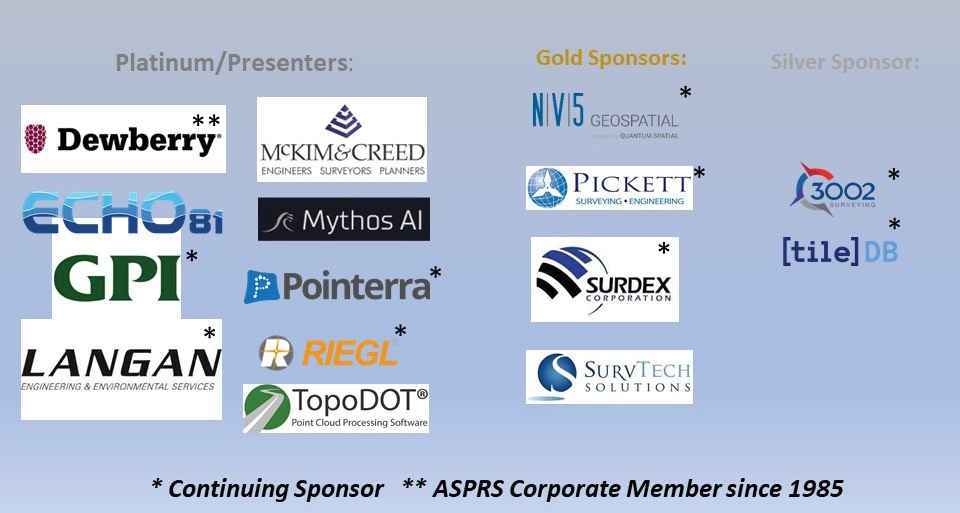
Figure 9: UF/FL-ASPRS Fall 2022 Workshop Sponsors.
FL-ASPRS has been soliciting corporate sponsors for the Lidar Workshop to help defray costs for the meetings; coffee, snacks, and lunch are all provided to participants, along with the venue and other services. The Board of Directors has developed a three-tier system so that corporate sponsors can choose the level of their support. While all levels of sponsorship receive recognition at the workshop, the sponsor’s corporate logo on the program and all promotional materials, Platinum-level sponsors are provided a 10-minute timeslot to present their services. The sponsors below are identified, in alphabetical order by sponsorship-level. Returning sponsors are identified with an asterisk (*; Figure 9):
- Platinum-level: Dewberry*, Echo81, GPI GeoSpatial*, Langan*, McKim & Creed, MythosAI, Pointerra*, RIEGL* and TopoDOT;
- Gold-level: NV5 Geospatial*, Pickett and Associates*, Surdex Corp.*, SurvTech;
- Silver-level: 3002, Inc.* and TileDB*.
Session 5: Academic presentations
David O’Brien, with Mark Bickel, Ken Comeaux, Chase Comeaux, Darron Goss, and Jason Ellard: Surveying and mapping Florida fresh water lakes with UAV-lidar, multi-beam sonar, and RTK GPS—SurvTech solutions
David presented a project in cooperation with Florida Water Management Districts mapping four freshwater lakes in Polk County (Lake Starr, Lake Eagle, Lake McLeod and Lake Wailes) and three freshwater lakes in Highlands County (Lake Angelo, Lake Denton and Lake Tulane). The significance to the workshop is that these lakes were mapped using a combination of UAV-lidar, in the uplands, multi-beam sonar in the subaqueous portions, and the gaps between lidar and sonar were filled in with conventional real-time kinematic (RTK) GNSS technology. The goal of the mapping was to construct a seamless digital terrain model (DTM) from the uplands to the lake bottom. Rather than detail each lake, David focused on Lake Starr in Polk County, Florida (Figure 10).
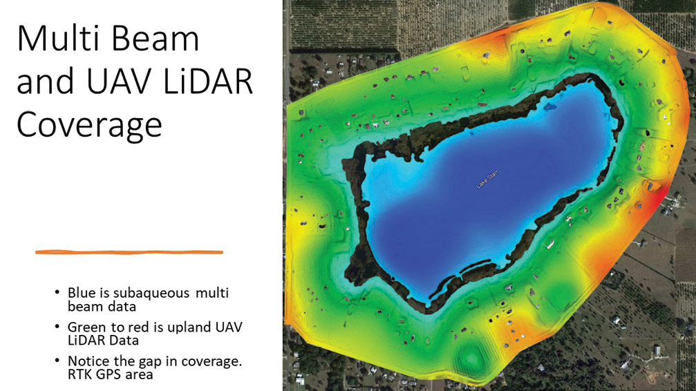
Figure 10: Lake Starr, Polk County, Florida showing areas surveyed by UAV lidar, multi-beam sonar and the “gap area” between the remote sensing surveys.
In the case of Lake Starr, the “gap area” was filled with RTK-GNSS survey (Figure 11) and cross-sections through the three datasets were evaluated for consistency. The final DTM (Figure 12) was constructed from the three survey datasets.
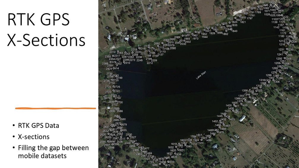
Figure 11: Lake Starr showing “gap area” with RTK-GNSS elevations.
David concluded his presentation by showing the workshop representative cross-section profiles and composite DTMs for other selected lakes in the project.
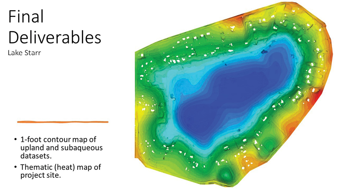
Figure 12: Digital terrain model for Lake Starr constructed from UAV-lidar, RTK-GNSS, and multi-beam sonar.
Laura K. Harrison, Steven Fernandez, and Kylie Dillinger: Terrestrial lidar for coastal heritage at risk—University of South Florida.
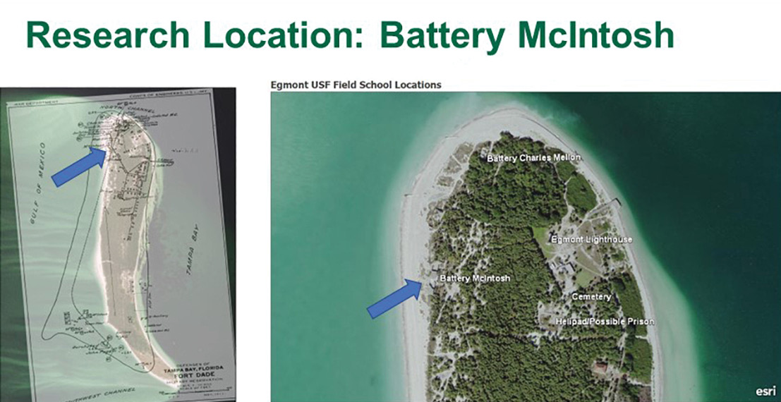
Figure 13: Battery McIntosh location on Egmont Key (right) and an overlay map showing loss of landmass during the past 150 years (left).
Dr. Laura Harrison gave the final presentation of the workshop, focusing on using terrestrial lidar to assess coastal heritage sites at risk for flooding related to sea-level rise. Egmont Key in Pinellas County, Florida is a 500-acre island located where the Gulf of Mexico meets Tampa Bay. It contains several irreplaceable cultural sites and this study focused on one, the Battery McInstosh site on the northern end of the island (Figure 13). Over the last 150 years, the island has experienced loss of over 50% of its landmass as a result of erosion and sea-level rise: thus preserving cultural features, such as the Battery McIntosh, is becoming increasingly important.
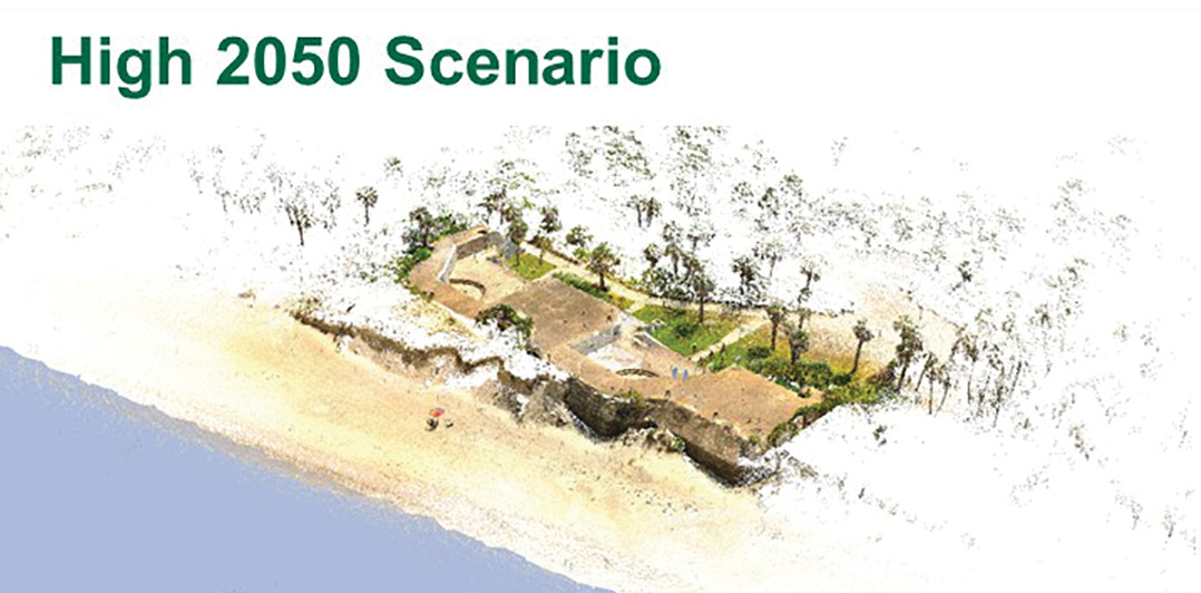
Figure 14: Battery McIntosh exposed based on NOAA high-water predictions for 2050.
Lidar scanning workshops for both students and concerned citizens were conducted to train staff for the terrestrial scanning of Battery McIntosh. The scans were initially conducted in May 2022. The data was georeferenced and processed into a LAS point cloud and a “fly-through” visualization was constructed. NOAA data was used to estimate the high-water scenarios expected for 2050 (Figure 14) and 2080 (Figure 15).
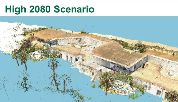
Figure 15: Battery McIntosh exposed area based on NOAA high-water predictions for 2080, showing high-water encroachment on Battery.
Laura concluded the presentation with an update on the erosion of Egmont Key resulting from Hurricane Ian’s landfall on 28 September 2022. The staff conducted one day of fieldwork, collecting 28 lidar scans on 8 October 2022. Direct shoreline measurements revealed a loss of over 385 cubic meters of shoreline resulting from erosion caused by the hurricane (Figure 16).
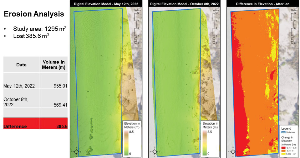
Figure 16: Erosion analysis of Egmont Key, Pinellas County, Florida before (May 2022) and after (October 2022) Hurricane Ian.