Demand for employees with education and training in advanced geospatial technologies is at an all-time high, because of the rapid growth of the lidar industry in recent years. To meet this demand, the University of South Florida’s (USF) Urban and Regional Planning program and Access 3D Lab have partnered to create the nation’s most advanced hands-on training opportunities in lidar and geospatial technologies (Figure 1).
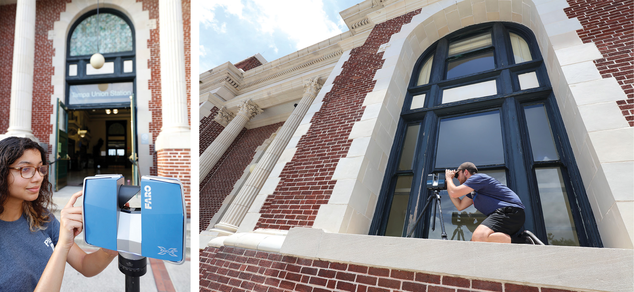
Figure 1: USF graduate students in the Master of Urban and Regional Planning program executing a scan plan at Tampa’s historic Union Station, a site on the National Register of Historic Places.
As one of the ten largest research universities in the country, USF is committed to innovation, and has recently made strategic investments in terrestrial, mobile, and aerial lidar. These investments support our training programs and propel research in urban planning, cultural heritage preservation, tourism, and destination management. Our programs involve undergraduate and graduate students in dynamic geospatial research, with projects taking place year-round in the United States and Europe (with a focus in Florida). As a result, each year we produce a cohort of highly-trained college graduates with experience capturing and processing lidar data in authentic, real-world scenarios, who are ready for the workforce.
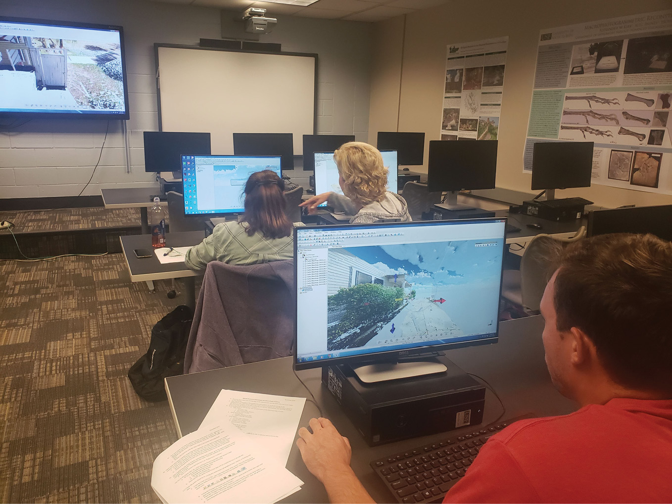
Figure 2: The 24-seat digital learning classroom at USF’s Access 3D Lab.
Lidar education
Lidar education and training opportunities at USF are diverse. A new graduate certificate in Smart City Technology is launching in Fall 2023. This covers GIS, lidar analysis, 3D modeling, programming, and terrestrial and mobile lidar. Courses in building information modeling (BIM) will be added to the curriculum for 2024. In addition, Access 3D Lab offers advanced training workshops in geomatics each May, which provide firsthand experience working with lidar in the field and in the lab. A key focus of all educational programs is hands-on experience tailored to career advancement. Classes are held in our state-of-the-art classroom, equipped with powerful Alienware Aurora R12 computers with 64GB of RAM, NVIDIA GeForce RTX 3080 graphics cards, and 1TB solid-state drives (Figure 2).
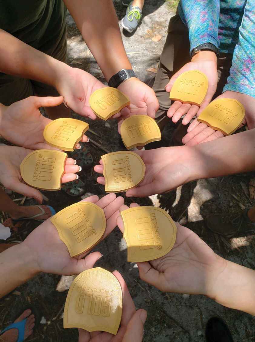
Figure 3: These students earned an @Access3D Gold Badge by completing independent lidar scanning and processing projects over the course of three intensive weeks.
Core courses in the new Graduate Certificate in Smart City Technology include: GIS for urban and regional planners; urban spatial analysis; and lidar and 3D applications of GIS. Electives include: terrestrial lidar field methods; digital design; programming for GIS; water resources applications of GIS; and public information management.
Workshop topics to date have been: Ybor City lidar: spatial and visual analysis of a National Historic Landmark District (2019); applied heritage and sustainability research (2019); sustainable tourism interpretation and citizen science (2021); cultural heritage and climate change geomatics (2021); geomatics for heritage, tourism, and sustainability planning (2022).
Access 3D Lab’s highest certification of applied technology skills is the @Access3D Gold Badge (Figure 3).
Lidar research

Figure 4: Orthophoto of a lidar scan of the R/V Weatherbird II, a research vessel owned by the Florida Institute of Oceanography. The scan data was captured with Faro Focus scanners over the course of four days and processed in Faro Scene.
USF’s lidar education and training programs support our ongoing fieldwork projects: students serve as crew members during data acquisition and help produce project deliverables, GIS maps, and project reports back in the lab (Figure 4). Some of our current research projects with an urban planning focus include using lidar to analyze King Tide flooding in South Florida and the Tampa Bay region; storm surge modeling for seven counties’ hurricane shelters; local GIS analysis and mapping of food sustainability in Tampa Bay for the Homegrown Hillsborough Food System Program; and developing a web-map application for a grant from the Florida Department of Early Learning to evaluate the Early Learning Coalitions’ capacity to support infant and early childhood mental health. These projects are funded through external grants.
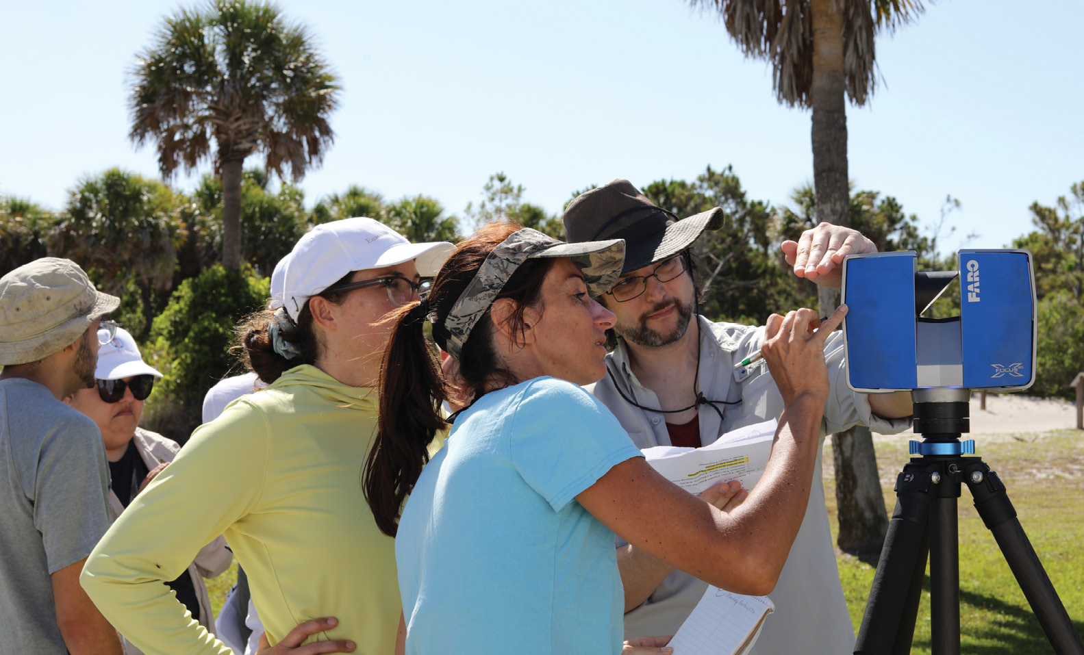
Figure 5: A team of students in the Cultural Heritage and Climate Change Geomatics workshop setting up the scan profile of a Faro Focus.
In addition, the USF training programs are using lidar extensively in the realm of cultural heritage preservation. For example, a student crew planned and carried out a terrestrial lidar scan of a historic lighthouse on Egmont Key, Florida, creating a durable record of the state of preservation and providing virtual access to the lighthouse’s interior, which is closed to visitors. Another student crew completed a terrestrial lidar scan of a historic Spanish-American-War fort, and then simulated the effects of sea-level rise on the structure using NOAA data in GIS (Figure 5). Yet another student crew scanned four murals in downtown Clearwater, Florida with terrestrial lidar and used measurements from those scans to program an augmented-reality app called ARTours Clearwater (Figure 6). The lidar-derived measurements ensure accurate tracking and image recognition within the app, allowing visitors to experience interactive digital stories while walking through a downtown arts district.
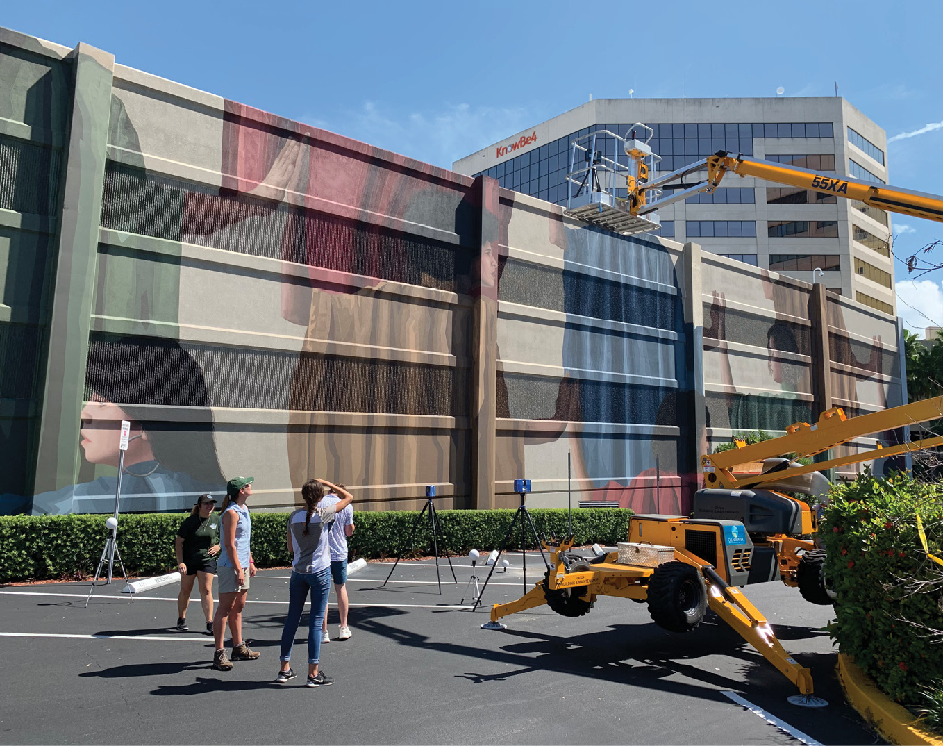
Figure 6: A lidar scanner on a hydraulic lift in Clearwater. A team of students scanned this mural and three others for the ARTours Clearwater augmented-reality walking tour.
Research faculty
USF’s lidar training and research projects are spearheaded by Steven Fernandez, MA, CCM, GISP and Laura K. Harrison, PhD, MA, RPA, who collaborate widely with USF faculty colleagues as well as partners in government agencies, Native American tribes, the nonprofit sector, associations, and community groups.
Steven Fernandez is a Research Assistant Professor in the Master of Urban and Regional Planning (MURP) program at USF. His expertise is in geospatial technologies, including GIS, UAS, lidar mapping and analysis. Steven has 22 years of experience in the private sector, working on site suitability and location analysis for commercial real estate. Those projects were completed for over 250 municipalities in 20 states, 50 of which required fieldwork data collection. His first experience with lidar was in 2001, modeling barrier-island erosion for the south shore of Long Island, New York. In 2010, he joined a research center at USF, where he was a GIS project manager for terrestrial and aerial lidar projects. The lidar projects were conducted throughout the eastern United States, US Virgin Islands, Hawaii, Europe, Mexico, and Guatemala. In 2018, he joined the MURP program, where he developed four graduate courses that focus on urban planning and lidar applications of GIS. These courses are the basis of the Graduate Certificate in Smart City Technology.
Dr. Laura Harrison is a Research Assistant Professor and Director of USF’s Access 3D Lab. Her research uses digital tools such as lidar, photogrammetry, and virtual and augmented reality to preserve heritage sites, expand public access and understanding of culture, involve the public with archaeology, and develop sustainable and resilient cultural heritage tourism. She has experience working with lidar in Spain, France, Italy, Turkey, and Serbia as well as multiple locations throughout the United States. Before she became involved with digital technologies such as lidar and 3D scanning, Laura worked on archaeological research projects in Greece, Turkey and New York. Her current research blends anthropological perspectives with advanced technologies to address real-world problems such as climate change, urban blight, endangered heritage, and invisible histories.
Get connected
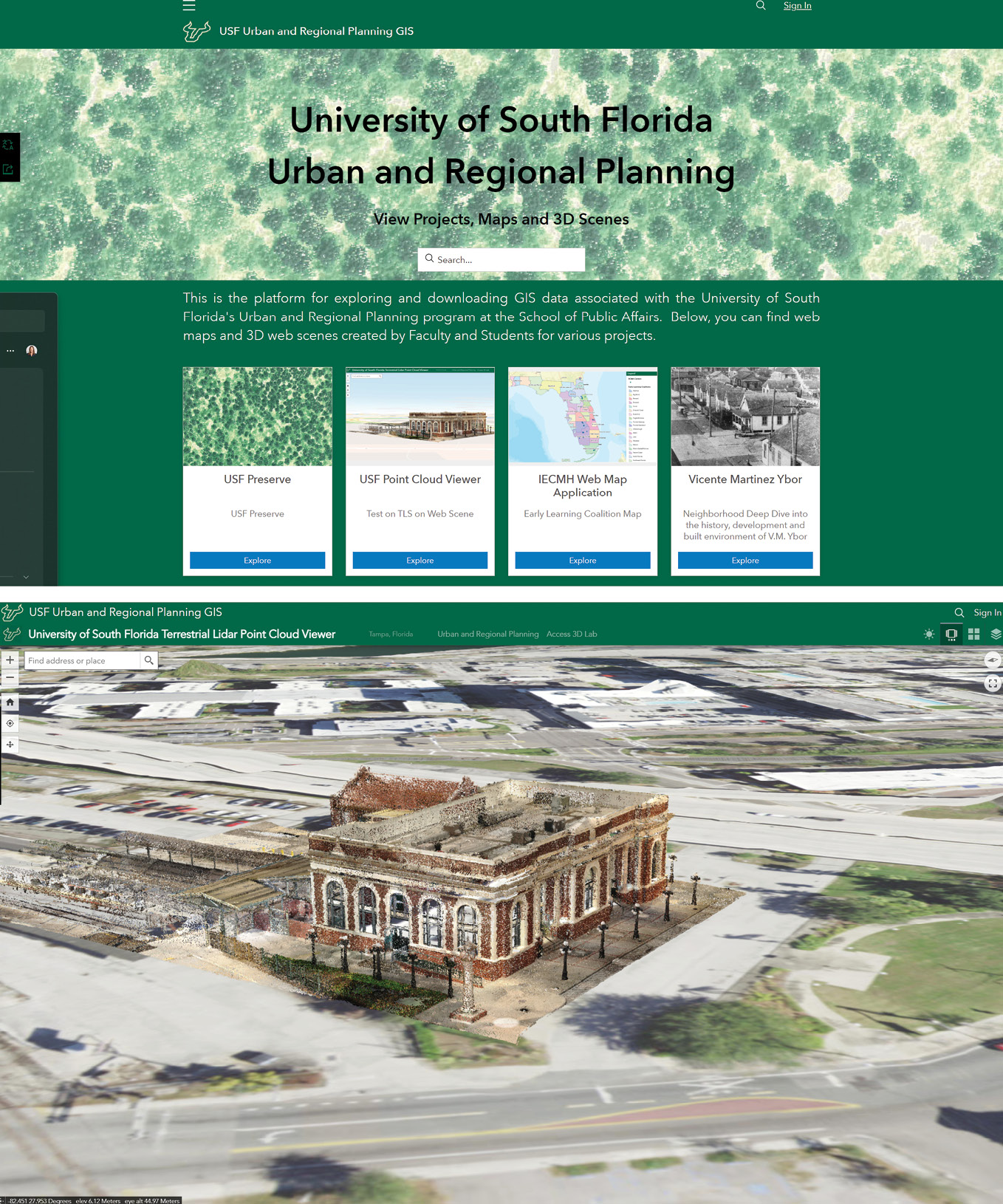
Figure 7: The USF Urban and Regional Planning terrestrial point cloud viewer. The top image shows the landing page, and the bottom image shows a georeferenced terrestrial laser-scan of Union Station in Tampa.
To stay up to date with the latest lidar training and education opportunities, and learn about our current research projects, visit usf.edu/arts-sciences/departments/public-affairs/murp and usf.edu/arts-sciences/labs/access3d. Our interactive web viewer (Figure 7) is available at the USF Urban and Regional Planning GeoHub: usf-urban-planning-usfurp.hub.arcgis.com. Also follow @MURP on LinkedIn and @Access3DLab on LinkedIn, Twitter, Instagram, Facebook and Sketchfab.
 Steven Fernandez, MA, GISP, CCM is a Certified GIS Professional with 23 years’ experience in GIS and urban planning. He is a Research Assistant Professor in the Master of Urban and Regional Planning Program at USF. Steven is also a Hillsborough County Planning Commissioner and the Education Chairman of the Florida Association of Cadastral Mappers.
 Laura K. Harrison, PhD, MA, RPA is a Research Assistant Professor and Director of USF’s Access 3D Lab. She has over 15 years of experience on 3D scanning, digital heritage and archaeology projects throughout Europe and the United States. She is also the Associate Editor of Studies in Digital Heritage.