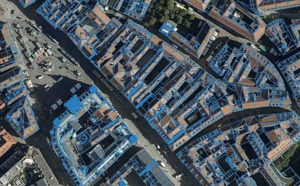
Graz, Austria • March 15, 2023:Eurosense has achieved outstanding results in creating high-quality watertight building models of Old Town Graz, Austria, at Level of Detail (LOD) 1 and 2, using Vexcel‘s state-of-the-art UltraCam large-format aerial systems and UltraMap photogrammetric processing software in conjunction with RhinoTerrain and DAT/EM software solutions. The Vexcel and RhinoTerrain products have proven to be a perfect match for Eurosense, as they complement each other seamlessly. In fact, Eurosense has been utilizing Vexcel imagery with RhinoTerrain for several years to produce 3D city models, and the workflow has become a familiar and trusted production tool within the company. As Eurosense engineers explain, “We have found that the combination and compatibility of these cutting-edge technologies are a winning formula for us.”
The particular project scope included images from Vexcel’s hometown, Graz, captured with an UltraCam Osprey 4.1 at 80% forward and 60% sideward overlap and 5 cm Ground Sampling Distance. Image post-processing and Aerial Triangulation of both nadir and oblique imagery was done within UltraMap. The resulting Exterior Orientations and TIFFs were imported into RhinoCapture for digitizing vectors in a 3D stereographic environment provided by DAT/EM’s Summit Evolution. Following, RhinoCity automatically produced exact LOD 2 building models by combining geometry and semantic information. In the final step, the 3D model was automatically textured with nadir and oblique imagery. Mapping and results are produced according to CityGML standards.
The combination of both solutions proves to be highly valuable – both in terms of the workflow and the quality of the end product. Vexcel and RhinoTerrain software solutions provide excellent interface integration, and support various export options in standard file formats. RhinoTerrain’s solutions offers a wide range of data formats (GIS, LiDAR, 3D formats, etc.) which enables the process to be done almost entirely inside Rhino, reducing the need to transfer data. As Eurosense attests, “The quality of the UltraCam images and the aerial triangulation results allowed us to map all the details of the roof with great accuracy.”
The project area posed a particular challenge. Old Town Graz is characterized by an organic and random layout with winding streets, irregularly shaped blocks and various roof structures without strict 90-degree angles. The challenge was to find a balance between flatness and XYZ precision. But this was achieved, thanks to the high quality of the imagery provided and the extensive library of models along with 3D editing and modeling tools in RhinoCapture, minimizing the number of vertices to be mapped. “The planarity of the roofs is perfect and guarantees that the final product can be optimally used for other applications such as noise propagation, obstacle studies, etc.”, claim Eurosense staff.
Eurosense encountered additional challenges when dealing with the numerous narrow streets of Old Town Graz. These created obstructions such as trees and adjacent buildings that often obscured the facades. While texturing in RhinoCity is mostly automated, users have the option to choose alternative images from different angles in the event of occlusions. Provided that the corresponding aerial images are of high-quality and were taken with high overlap. “The presence of good quality oblique imagery makes it possible to not only create complex roofs, but also overhanging geometry and, if needed, façade details such as windows and doors”.
“There were no unpleasant surprises”, Eurosense sums up the project. “The integration of both solutions allows us to produce watertight LOD 2 models in the best quality and highest efficiency.”
About Eurosense
Eurosense is one of the leading aerial surveying and geo-data companies in Europe, with headquarters in Belgium. The group was created in 1964 and has offices in Belgium, The Netherlands, Germany, France, Hungary, Slovakia, Poland, Bulgaria and Romania. Specialties of Eurosense include: HD aerial imagery (up to 2 cm GSD), true orthophotos, aerial Lidar, 3D-modeling, aerial thermography, trees inventory and health analysis, GIS-consultancy, and other geo-related queries. Customers are both public (government) and private (such as architecture, construction, engineering, telecommunication, utility and solar industries).
About RhinoTerrain
RhinoTerrain develops a range of software dedicated to 3D geomodelling to meet the needs of various application areas: GIS, Civil Engineering, 3D Engineering, Photogrammetry and Solar Calculations. Within our range of solutions, RhinoCapture™ offers an advanced and efficient set of functionalities to capture 3D data, even for complex urban configurations. Its features and stereoscopic working environment ensure an enhanced user experience for maximum productivity. RhinoCity™, with its unique 3D building modeler and extensive automatic texturing capabilities, is the ideal tool for producing high-quality, textured 3D data that can be used directly in the CityGML format. Millions of 3D buildings have been created worldwide using this powerful combination.
About Vexcel Imaging
Vexcel Imaging, a global leader in aerial imaging, develops cutting-edge large-format aerial cameras and photogrammetric software with innovative approaches, and places an emphasis on continuing product upgrades and world-class support. The broad UltraCam aerial camera portfolio covers all applications in airborne photogrammetry—from nadir to oblique to wide-area data collection. UltraCam data is processed with the UltraMap photogrammetry software, providing an end-to-end processing workflow for highly automated, quality data products that include point clouds, digital surface and terrain models, orthophotos and 3D TINs.
