Leicestershire, UK, 16 March 2023 – Cardiff Council, UK, is using an aerial map of trees to help it prioritise essential works in order to reduce the risk of surface water flooding. Created by Bluesky International, the National Tree Map provides accurate height, location and canopy coverage data for more than 400 million trees across the UK. When combined with data detailing the location of highways drainage gullies, this intelligence is helping Cardiff Council prioritise cleansing and street sweeping programmes to reduce the risk of fallen leaves blocking drains. The Bluesky National Tree Map data is also helping the Council engage with local residents to minimise blockages in streets with the highest risk.
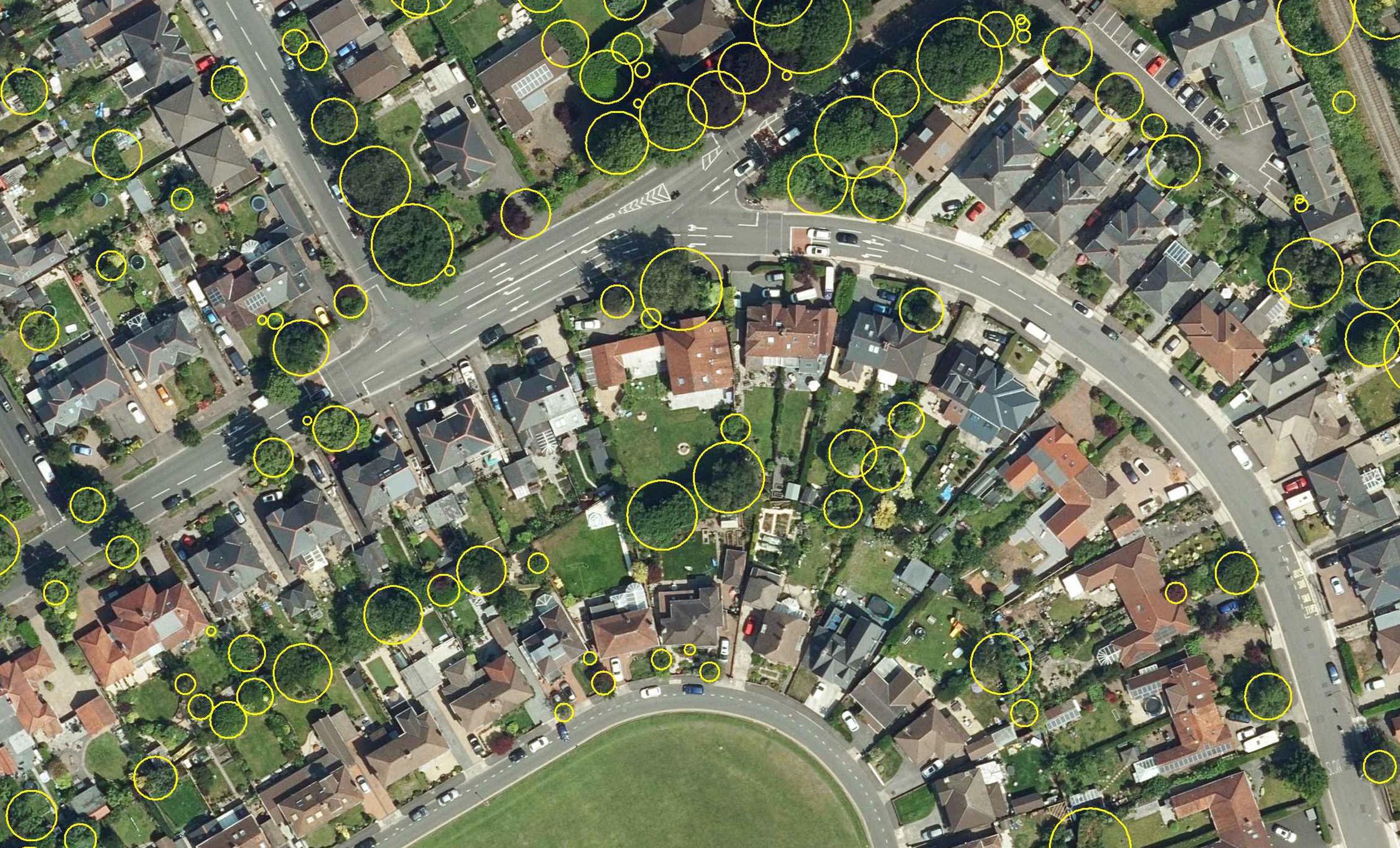
Tree symbols overlain on the aerial photo.
“This is a simple but highly effective way of using location-based intelligence to achieve operational benefits,” commented Councillor Caro Wild, Cabinet Member for Climate Change at Cardiff Council. “A desktop study, which combined the Bluesky National Tree Map data with internal map layers, including gulley locations and street gazetteers, allowed us to identify gullies with the closest proximity to trees. This has allowed us to prioritise maintenance and cleansing programmes and engage with residents and other stakeholders.”
The Council currently has responsibility for around 100,000 highway gullies, or drains (pits covered by an open metal grating typically located at the edge of the highway), which are designed to drain rainwater, and other surface run off, into a drainage system where it can be conveyed to an appropriate discharge point.
As part of the national dataset, the Bluesky National Tree Map has captured data of trees 3 metres and taller in the Cardiff area and has been continuously used by various departments within the Council since 2020. Using the open-source Geographical Information System QGIS, to compare the proximity of trees and gullies, close to 5,000 or five percent of gullies were deemed to be at risk of leaf fall. This intelligence allowed the Council to identify streets with the largest number of at-risk gullies and prioritise these for its autumn gulley cleansing and street sweeping programmes.
Other applications of the Bluesky data used by teams at Cardiff Council include planning, drainage and arboriculture. For example, the data will help officers with approval of Sustainable Drainage Systems (SuDS), mandatory in Wales for developments of 100 metres square or more and will allow assessment of the impact of trees on other types of watercourses to help prevent flooding. The National Tree Map data will also help arboriculturists plan maintenance work for protected trees and inform planting strategies for parks and urban forestry.
Ralph Coleman, Sales Director at Bluesky, added, “The feedback we get regularly from users of the National Tree Map is that it enables analytical work to be carried out on the desktop whereas previously site visits might have been needed, this saves time and valuable resources. The National Tree Map delivers accurate insights rapidly, shortening lead times for valuable projects that contribute to the safety and security of the public. The data is used by a wide range of businesses and organisations from local authorities and academia to architects and planners, renewable energy companies and environmental organisations.”
The National Tree Map, which is unique to Bluesky, was launched over 11 years ago, initially to address the risk of building subsidence for the insurance sector. It is created using innovative algorithms and image processing techniques, using the most up-to-date aerial photography and terrain data for the whole of Great Britain and Ireland. It provides a detailed reference as to the location, canopy cover and height of trees 3m and taller which can be applied alongside other data to establish ownership, proximity to other features or assets, and relationships between demographic, economic or social data.
About Bluesky and the National Tree Map
Bluesky’s National Tree Map is created using innovative algorithms and image processing techniques in combination with the most up to date and detailed aerial photography. In addition to the three vector map layers; Crown Polygons, Idealised Crowns and Height Points, the Bluesky National Tree Map also includes an attribute table including unique identification for each crown feature, height attributes and area calculations. The data is available in a range of formats for use in GIS, CAD and online mapping tools and is currently available for the whole of England, Wales, Scotland and the Republic of Ireland. Bluesky International is the leading aerial survey and geographic data company in the UK producing and maintaining seamless digital aerial photography and height data on a national scale in both Great Britain and the Republic of Ireland. Bluesky also undertakes bespoke surveys, including LiDAR, for a range of public and private sector clients. Bluesky International operates a range of aircraft and sensors including three Ultracam Eagle Mark 3s and two CityMappers which allow the simultaneous collection of vertical and oblique imagery, as well as LiDAR data, and a Galaxy LiDAR which is mounted with a thermal sensor and survey grade camera. These systems put Bluesky International in the enviable position of being able to provide customers with unique and cost-effective geospatial solutions. As well as being an established and respected aerial survey company Bluesky International is also highly innovative and continually strives to develop new products and services by embracing new technology and methods. This has resulted in the development of some unique products such as the National Tree Map (NTM). These datasets underpin long term contracts with local and central governments and many major blue-chip companies from a range of market sectors including financial services, utilities, telecoms, web portals, construction and environment. Bluesky International has offices in the UK, US, Republic of Ireland and a dedicated production centre in India. https://www.bluesky-world.com/
