A local government client granted BDS Topografie, a leading Romanian surveying company, a project to acquire with a UAV, process and deliver for municipal use high-resolution photogrammetry and lidar data of the Rarau ski resort. BDS Topografie carried out a drone survey to deliver maps and 3D elevation models to support a ski resort development strategy. The aim was to study the situation of existing slopes and identify possible areas for new trails and slopes that would minimize the scale of tree cutting. The workflow from mission planning to data collection and post-processing took one day.
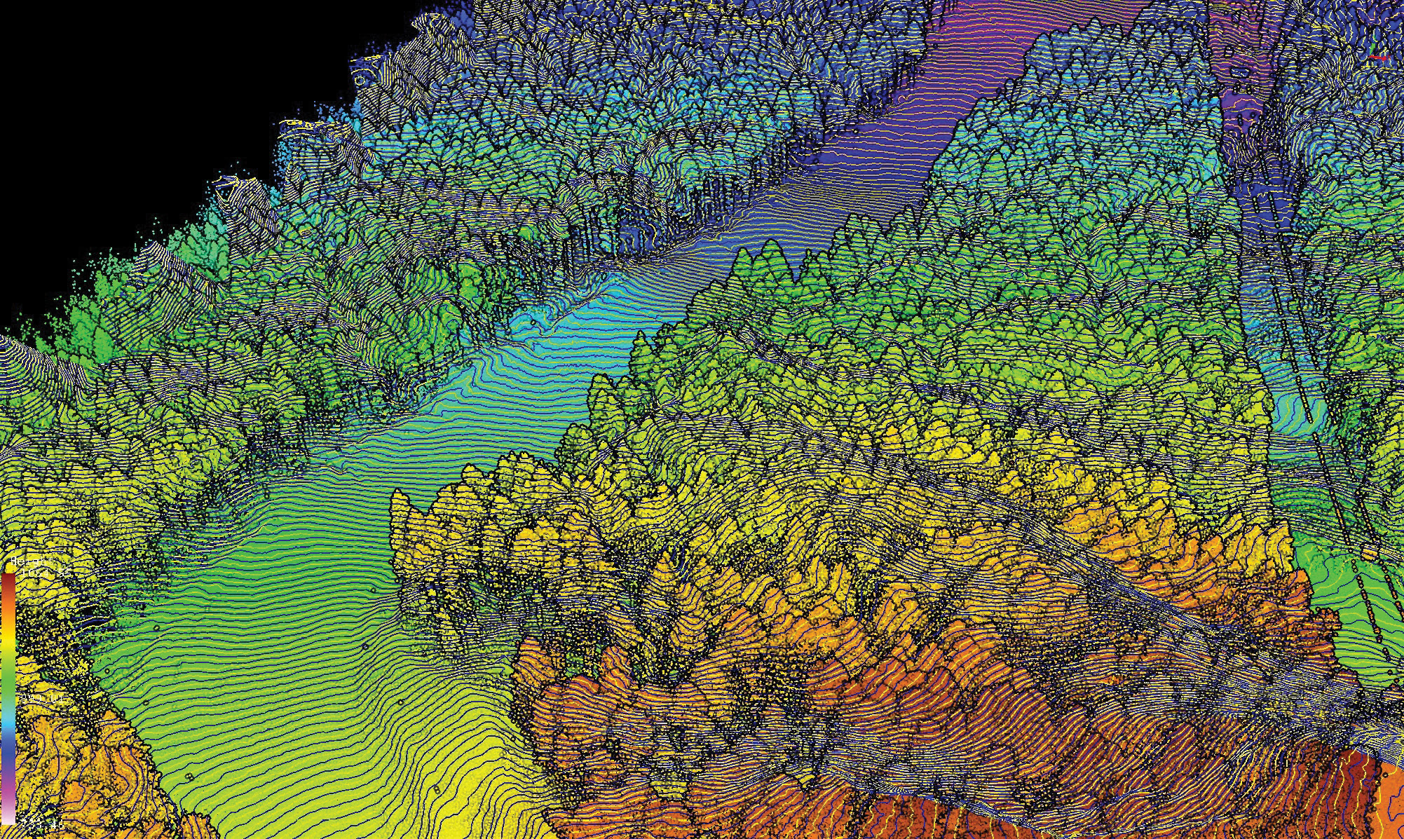
3D view of contour lines together with lidar point cloud captured by TOPODRONE LiDAR 100 LITE.
Raising interest in the Rarau ski resort
The Rarau ski resort is located in the Rarău massif, a subgroup of the Moldo-Transylvanian Carpathians, located in Romania. It is a part of the Romanian municipality of Câmpulung Moldovenesc and is built according to international standards. It is a wooded area on the northern slope of the legendary mountain. Thanks to the northern exposure and the location in an area where the snow does not melt completely until April, the slope attracts many tourists both from EU and globally.
The municipality approached Simion Bruma, general manager of BDS Topografie, to contribute to the strategy of the Rarau ski resort development and perform advanced airborne surveying using a combination of photogrammetry and lidar techniques to cover the resort infrastructure and nearby forest area.

Screenshot from Map Pilot Pro with the main screen showing the view from the drone’s FPV cam.
BDS Topografie specializes in topographic surveys required for investment projects in road and railway infrastructure, as well as establishment of geodetic networks for measurements and stake-out. It is well known for surveying in Romania: the company was launched back in 2012 as a land surveying service company and purchased its first drone to diversify its services portfolio in 2017. Thus, it has been performing UAV-based photogrammetry since 2017 and lidar since 2020.
Challenging CAD and point-cloud data delivery
In the surveying project for the Rarau ski resort BDS Topografie used a UniStrong G10 System GNSS base station, a DJI Matrice 210 V2 with a DJI Zenmuse X4S camera payload, together with TOPODRONE PPK module, TOPODRONE LiDAR 100 system, including Velodyne Puck sensor (VLP-16), survey grade GNSS receiver, IMU and microcomputer. The hardware can capture data over many square kilometers of mountain areas in heavy snow, the only limitation being the batteries. This area, like many others in Europe, had not previously been comprehensively surveyed with drone-based approaches. Moreover, it could take authorized land surveyors several months to conduct the same project with traditional methods—and even then there would be limitations on the information collected about trees. The combination of photogrammetry and lidar equipment mounted to the same drone enabled BDS Topografie to perform two types of surveying during the same flight and obtain simultaneous, multisensor data acquisition.
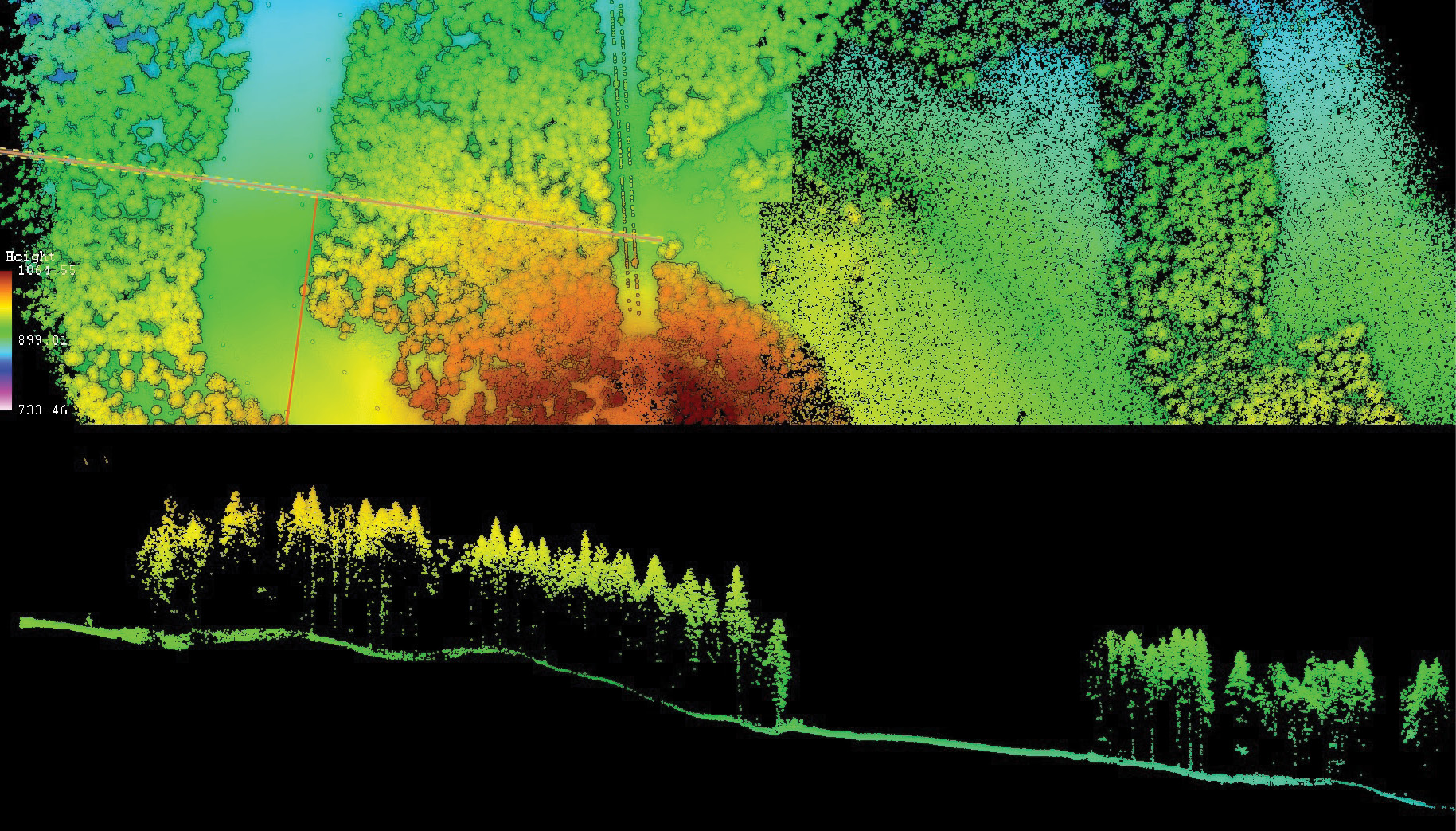
Upper: Lidar point cloud colorized by elevation of the existing Rarau ski resort. Lower: Profile of the terrain level beneath tree canopy.
“I was challenged with a few things in addition to weather conditions. I had to perform the flights keeping in mind the existence of rocks and running cables. That is why the terrain-aware mission planning was crucial for me in order not to damage the equipment,” Simion Bruma explains. He performed six missions in the field, planned the same day in advance in the office with the use of Map Pilot Pro software.
Once flights were completed, the trajectories were calculated and lidar post-processing was performed with TOPODRONE software. Within 15 minutes the post-processing software solution allowed the team to check the accuracy of flights and obtain point-cloud data. “I have been working with TOPODRONE LiDAR systems, both hardware and software, since 2020 after I completed the training in the company’s Swiss office,” Simion Bruma clarifies. “I like working with lidar data for dense forest surveying purposes—data can be obtained and processed fast, giving very accurate information about the size and height of trees as well as the space between them. The most important requirement is obtaining the digital elevation models (DEMs), which allow me to produce all kinds of maps, in different formats like tiled, vector or raster maps.”
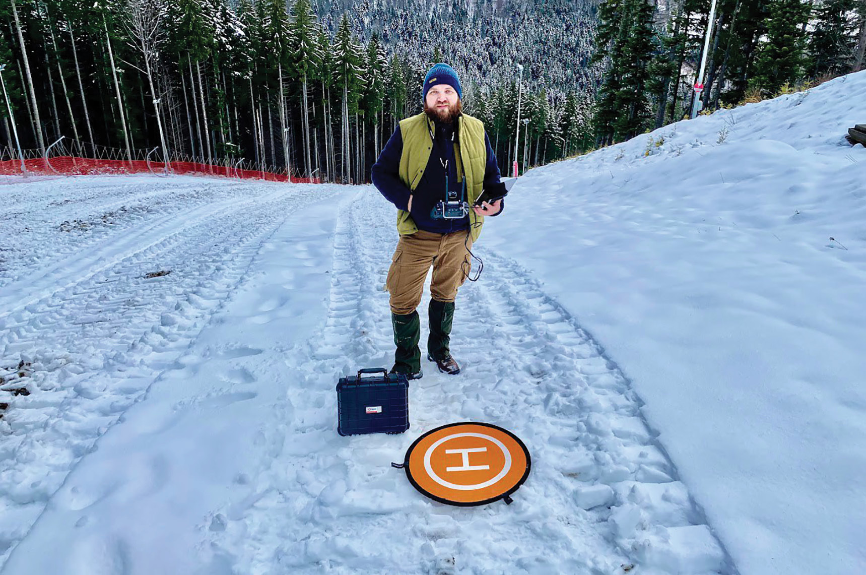
Simion Bruma operating a drone by visual line of sight (VLOS), constantly evaluating altitude and flight path.
According to Simion Bruma, however, the local Romanian community still prefers regular topographic maps in addition to point cloud data. “It took me two days to extract CAD vector data from the point cloud obtained from lidar and photogrammetry. We use custom software that we developed for the purpose of converting WGS84 survey projection coordinates into the local projection, Romania Stereographic 1970.” When he was at Intergeo in 2022, he discussed with participating surveyors the issue of how to shift clients’ mapping habits from CAD vector data to point clouds.
Advancing mountain airborne surveying
Using the latest airborne data acquisition and processing technologies, BDS Topografie was able to conduct a time- and cost-effective study of the requested area with complex terrain. Used in comparison with traditional mapping, such a survey can facilitate enhanced and more accurate assessment of mountain areas at multiple scales from a resort to regional levels. This in turn can inform strategies to best manage and mitigate not only trail and slope planning with minimal interference in forest ecosystems, but also to protect local communities and support the prevention of avalanche risks.
Simion Bruma is a certified land surveyor with over 15 years of experience in cartography, cadaster and forestry. He is CEO at BDS Topografie (www.bdstopografie.com) and a vice-president at the Union of Surveyors from Romania Cluj branch (www.ugr.ro).