Today, Esri released the Sentinel-2 Land Cover Explorer (https://livingatlas.arcgis.com/landcoverexplorer/), a new app that lets you explore how the planet is changing over time. Based on Sentinel-2 10-meter land use land cover data from Esri, Impact Observatory, and Microsoft, the new app lets you interactively compare and analyze land use land cover data for the entire planet between 2017 and 2021. You can view 10-meter resolution Sentinel-2 imagery in one of six different renderers (including natural color, color IR, NDVI, and others) or as processed land use land cover data. You can step through each year of imagery as a time slider or interactively compare two different years at once through a swipe function. You can click on any land use land cover class (such as trees, built area, or crops) in the app to filter imagery by that class.
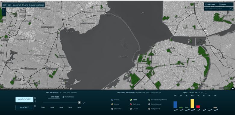
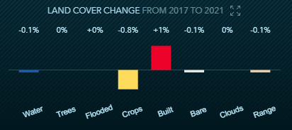
When in Step Mode, the app includes a chart that summarizes land cover in the visible extent of the app. In Swipe Mode, the app includes a chart that calculates land cover change between the selected years in the visible extent of the app.
As you pan and zoom the app and toggle various modes, the app URL updates so you can easily share your exact view and analysis with others. The app also lets you easily download data for further analysis. Each time you launch the app, it preloads to different spot on the planet where change is visible over the 5-year period covered by the data.
“The Sentinel-2 Land Cover Explorer will be invaluable for helping decision-makers unlock critical insights about land use, particularly as sustainability becomes a pressing global concern,” said Sean Breyer, Esri program manager for ArcGIS Living Atlas of the World.
You can find more details about the app in the ArcGIS Blog: https://www.esri.com/arcgis-blog/products/arcgis-living-atlas/imagery/global-land-cover-revealed/
