The 3D Elevation Program (3DEP) of the United States Geological Survey (USGS) entered its first year of production in 2016. With the help of funding partners, private sector mapping companies and the lidar industry, this nationwide mapping program has resulted in more up-to-date elevation data. At the end of 2021, 84% of the U.S. either had access to elevation data or was gathering elevation data that met 3DEP requirements for high accuracy and resolution.
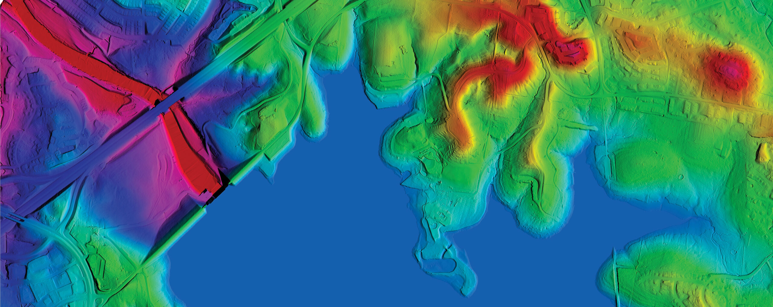
Elevation data provides insights around the J Percy Priest Reservoir and J Percy Priest Dam near Interstate Highway 40 (I-40) in East Nashville, Tennessee. Image shows a blend of digital elevation model (top) and digital surface model (bottom). Image shared courtesy of USGS.
As a result, many states are now using this elevation data to inform critical decisions and support evolving USGS initiatives, including its 3D Hydrography Program (3DHP), which aims to update the National Hydrography Dataset (NHD) to enhance the ability to discover and share water-related analytics. One state that has recently started using 3DEP data and preparing for 3DHP is Tennessee.
Collaborative data collection, application
Gathering the elevation data for 3DEP in Tennessee was a collaborative effort. In 2015, USGS assigned Woolpert the responsibility of working with state officials to collect Quality Level 2 (QL2) or better lidar data. According to the National Enhanced Elevation Assessment (NEEA)1, Tennessee could gain $6.3 million in new benefits annually from 3DEP. These would accrue from utilizing elevation data for multiple business uses, including:
- Agriculture and precision farming
- Flood risk management
- Natural resources conservation
- Construction and infrastructure management
- Forest resources management
- Aviation safety and navigation
- Geologic resources hazard mitigation and assessment
- Renewable energy resources
- Stream and river resource management
- Disaster response, law enforcement and homeland security
Dennis Pedersen, the GIS services director for Tennessee’s Department of Finance and Administration, observed that Tennessee Department of Transportation (TDOT), Tennessee Department of Environment and Conservation (TDEC), and Natural Resources Conservation Service (NRCS) are among the many organizations utilizing 3DEP data to enhance the success of their projects.
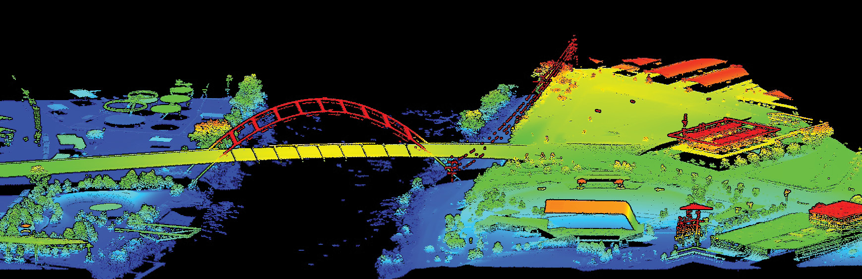
The Korean War Veterans Memorial Bridge in Downtown Nashville, Tennessee. This is an oblique profile view of a digital surface model from QL1 lidar data at 8 points per square meter. Image shared courtesy of USGS.
“The high-resolution lidar data has been very helpful on emergency landslide projects on state transportation routes,” said Douglas Ford, civil engineering manager at TDOT. “We also use these data for detailed drainage studies and flood-plain mapping.”
As state departments benefit from elevation data, other organizations stand alongside them in utilizing it for critical projects. For example, the U.S. Army Corps of Engineers (USACE) Nashville District is using Tennessee’s 3DEP data for various purposes.
“We use the elevation data constantly in our engineering and construction division to accomplish many diverse projects and workflows,” said Matthew Davis, geographer in the engineering and construction division of USACE. “It is utilized in geology, hydrology, survey, mapping, civil site and more. It is an invaluable resource for us.”
Private companies in Tennessee are using the state’s lidar data and derivatives as well. When state officials surveyed businesses to ask for specific use cases and advantages of the elevation data, they discovered the following insights:
- The state’s 3DEP data is a significant cost saver for the developer who is doing a feasibility study to see if a project can happen before performing a topographic survey and engineering design.
- The availability of the data provides the opportunity to give clients a more detailed and accurate product.
- Lidar-derived digital elevation models (DEMs) help perform hydrologic and hydraulic analyses with conceptual and preliminary grading for development projects.
- The data is an asset for planning surface drilling programs. Slope calculation on the DEM shows logging roads that would not have been visible through other methods due to tree cover.
Accessibility has also helped decision-makers benefit from the state’s lidar data. Tennessee makes the data approachable, organized and easy to navigate, enabling quick and effective application for officials and residents alike.
“With the high-resolution lidar data, local governments can make effective decisions on flooding and flood risk management, which directly protects their communities,” Pedersen said. “These data also give residents access to better online mapping tools and potential tax savings.”
Using 3DEP as the foundation for 3DHP
While the current applications for Tennessee’s elevation data are vast, decision-makers in the state are ready to use it for a broader purpose: 3DHP. This program is critical because it will significantly improve the level of inclusion, currency and detail of hydrography data to reflect how the landscape and seascape have changed over time.
“Knowing how to map water is the ultimate end-game of all this mapping,” said Volkan Akbay, geospatial project manager at Woolpert. “It’s about understanding how water will move and interact. Launching 3DHP is the first step in building a vertically integrated dataset of anything that can affect hydrology, whether it’s soils, culverts or levies.”
Achieving this ambitious goal requires multiple components, the primary one being accurate, high-resolution elevation data, which 3DEP provides. Engineers can produce a 3D stream network and hydrologic units as well as support hydrologic and hydraulic modeling.
Additionally, states can use 3DHP data to protect and enhance their communities. When asked what specific advantages this new initiative could provide to state officials, Akbay said, “The currency and inclusion of these data and deriving a 3D stream network from lidar data goes a long way in helping with so many different things. From environmental planning to transportation to flood detection, 3DHP can help with everything.”
Officials in Tennessee have realized the benefits 3DHP can deliver. The Department of Finance and Administration, STS-GIS Services recently carried out a survey and identified two departments that would significantly benefit from 3DHP: TDOT and TDEC.
How 3DHP will enhance TDOT
The survey of TDOT staff members revealed three divisions that could improve through 3DHP. The first is the Hydraulic Design Section within the Structures Division, which would benefit from increased accuracy of flood flow calculations. This would be due to better information on the stream network and enhanced elevation data, including connections to groundwater and engineered hydrologic systems. With increased accuracy, the Hydraulic Design Section could properly size critical infrastructure.
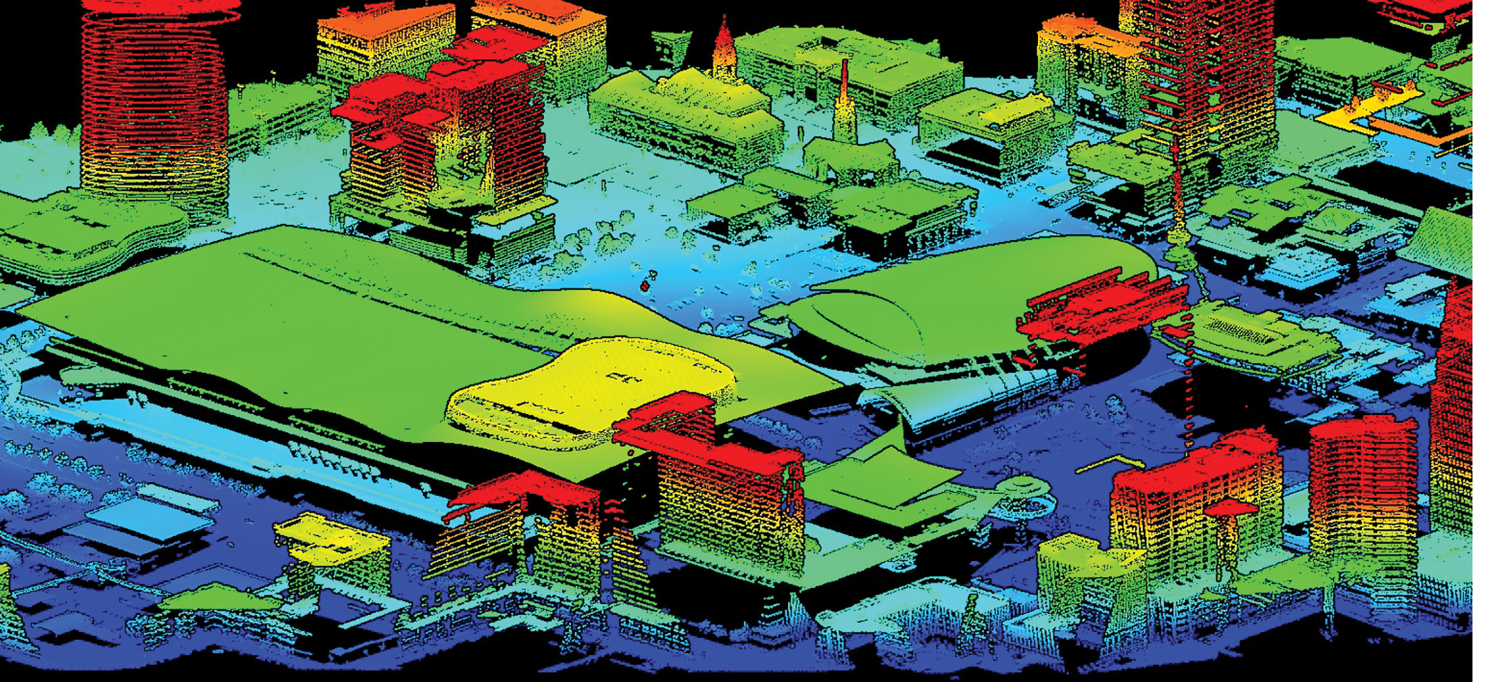
DEM of the Bridgestone Arena and the surrounding area in Nashville, Tennessee, derived from USGS QL1 lidar data at 8 points per square meter. Image shared courtesy of USGS.
“More accuracy in flow calculations would lead to more accurate sizing of bridges and drainage structures on Tennessee roadways and would assist in our calculations for bridge scour,” said Wesley Peck, civil engineering manager at TDOT.
The Long-Range Planning Division is the second office expected to see benefits from 3DHP. The division’s planning supervisor, Chris McPhilamy, said 3DHP would offer a healthier and more complete dataset to perform GIS analytics. He explained that these data points would significantly enhance the geohazards project the division is seeking to develop, and the 3DHP data would support more robust water-modeling functionality. That information could help determine where floods may occur and where underground springs or watersheds could potentially erode the roads.
“Further analysis could most likely be done to look at the relationship between land-use, environmental justice and site suitability,” McPhilamy said. “We could possibly even look at how the more detailed watershed plays into automobile crashes and how we can create proper drainage for our infrastructure.”
Additionally, 3D hydrography data and related insights could help staff research features that receive stormwater discharges from state-owned outfall locations throughout Tennessee.
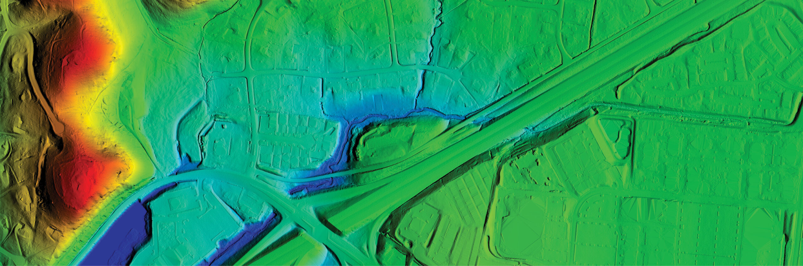
This DEM shows Highway Interchange I-40 at Highway 70 South and the surrounding area in Bellevue, Tennessee. Image shared courtesy of USGS.
“If there is a traffic incident that exceeds established thresholds for reporting requirements, the section examines any receiving waters near the location to determine its identity and if the water resource is considered impaired,” said Klint Rommel, facility compliance section manager in TDOT’s Environmental Compliance Division. “These data would be of great benefit to expedite that process compared to the method the section currently utilizes.”
Rommel said he believes 3DHP data could have additional benefits for the division, particularly when planning a project. During the planning phase, staff members prepare documents to showcase improvements to an existing roadway or the proposed alignment of a new roadway. They also conduct research to determine if water features exist within the proposed footprint of the project. 3DHP data could enhance this process by helping the Environmental Compliance Office decrease potential impacts on features and adjust the alignment if necessary.
How 3DHP will benefit TDEC
Similarly, three divisions in TDEC are positioned to experience significant benefits from 3DHP. Chief among them is the Division of Water Resources, which could use high-resolution hydrographic data to enhance various programs and systems, including the following:
- Safe Dams Program: 3DHP could add value by helping staff analyze dam hazard values to better determine the downstream impacts if a dam fails.
- Municipal Separate Storm Sewer Systems: With hydrographic data, workers could have higher-resolution analytics to determine riparian corridors and assess environmental factors that could impact water quality along state waters.
- Public Water Supply Source Water Protection: 3DHP data could help support decision-making after spill events to ensure workers know whether public water supply sources are at risk for contamination.
- Natural Resources Unit and Aquatic Resource Alterations: Data from 3DHP could help support more robust assessment of regulatory waters in the state. It could also be used in GIS applications to support permitting decisions for Aquatic Resource Alterations.
- Compliance and Enforcement: Staff in this unit could use 3DHP data to assess the impacts of water quality when receiving information regarding reported discharges of contaminants.
The Division of Natural Resources has various use cases for 3DHP data as well. Based on survey responses, the office plans to use the high-resolution data for some of the following reasons:
- Better understand the current and potential distribution of specific natural communities and species
- Improve efficiency in discovering new places to search for natural communities and rare species
- Enhance capabilities to identify potential impacts on natural communities and rare species when examining material in environmental reviews
- Plan for site selection and reduce the impact on natural resources
- Inform restoration or ecological management and implementation
- Support land-protection efforts for high-value aquatic systems affected by surface-to-groundwater connections.
The third TDEC office expected to reap benefits from 3DHP is the Division of Geology. Survey results show that the data could help improve the mapping of hazard features, particularly sinkholes and other subsidence features. With karst terrain, including sinkholes, caves and sinking streams, abundantly present in Tennessee, the updated hydrography dataset would be ideal for mapping features at higher resolutions. Additionally, the division could use the data to update hydrologic features on recently generated geologic base mapping products.
As USGS rolls out 3DHP, Tennessee is ready to collect and employ high-resolution hydrographic data similar to how it has been successfully employing 3DEP data. USGS has already started tackling implementation milestones, for example assembling governance and communication structures and launching pilot programs in Alaska and the continental United States. In fiscal year 2023, USGS plans to begin contracting out 3DHP data acquisition and processing.