Asset and Vegetation Management Applications Help Utilities Minimize Risk and Improve Reliability of Electric Distribution Network
INSITE cloud application that visualizes and manages utility data
Hollywood, Fla., October 11, 2022 – NV5 Geospatial, North America’s most comprehensive geospatial data firm, is transforming the way utilities manage their distribution networks with remote sensing data analysis. Having mapped more than 5.5 million miles of utility distribution networks in the U.S., NV5 Geospatial offers proven solutions that combine a variety of lidar and orthoimagery sensors on mobile and airborne platforms to acquire data for both asset and vegetation management. Analysis of this geospatial data then enables electric utilities to minimize risk and maximize reliability, while increasing efficiency.
INSITE cloud application that visualizes and manages utility data
“An aging grid, workforce shortages, increasing energy demands and an uptick in major weather events are combining to create a perfect storm that could impact reliability, customer service and safety for electric utilities across the country,” said Eric Merten, Vice President, Commercial Group at NV5 Geospatial. “A boots-on-the-ground approach to management cannot keep up with demands related to aging equipment, compliance, pole loading and vegetation encroaching on infrastructure. NV5 Geospatial’s innovative remote sensing applications and data analysis tools give utilities the power to proactively address problems in their distribution network before they impact operations or customers.”
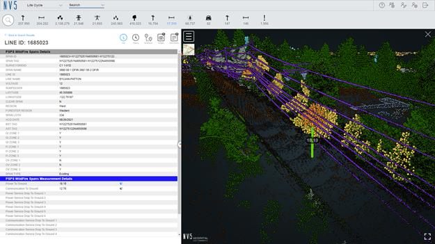
Built on the success of its remote sensing applications for utility transmission networks, NV5 Geospatial’s distribution management solutions offer end-to-end capabilities – from acquiring accurate, high-quality geospatial data to data analysis and visualization using custom viewers and enterprise GIS – and can be customized to meet utilities use cases and budgets.
With a single data collection via remote sensing, NV5 Geospatial makes it easier for utilities to manage, maintain and monitor their distribution networks, whether it relates to their assets and infrastructure, or vegetation that may interfere with it.
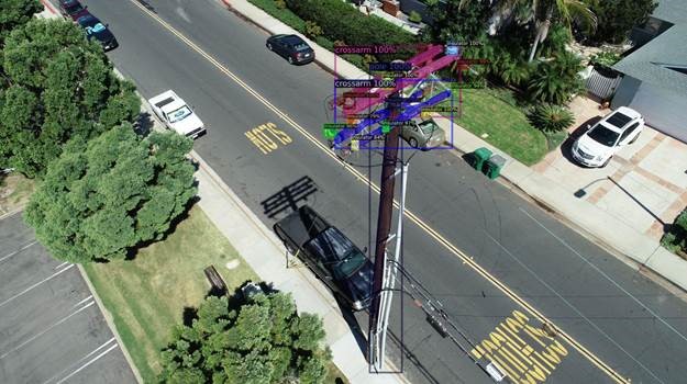
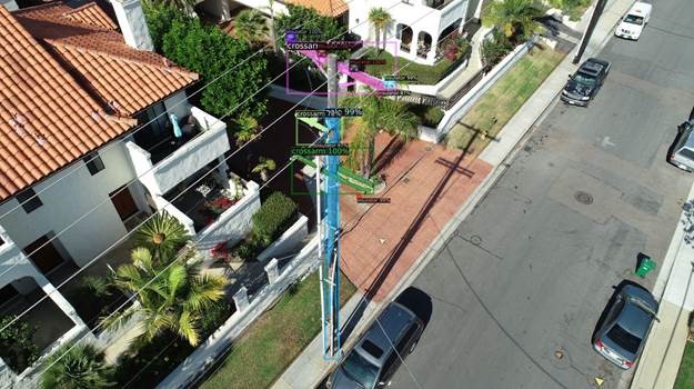
Asset Management
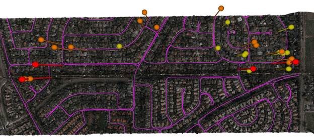
A distribution network (purple) and vegetation risks (red/yellow pins)
NV5 Geospatial remote sensing processes involve more than 25 asset measurements, quickly delivering a comprehensive inventory of utility pole capacity with greater accuracy than traditional boots-on-the-ground surveys. Using NV5 Geospatial’s tools, distribution network asset managers can:
- Achieve compliance with National Electrical Safety Code (NESC) clearance guidelines
- Get clear visibility into joint use of poles to prevent pirating, which can be a safety risk because of overcapacity issues, and increase revenue opportunities if poles are capable of supporting attachments of additional communications wires and equipment
- Ensure safe pole loading through analysis of weight load on each pole to prevent breaking or falling during severe weather and get insight into whether the pole can handle more joint use applications
Vegetation Management
A distribution network (purple) and vegetation risks (red/yellow pins)
NV5 Geospatial’s remote sensing data also can help vegetation managers quantify vegetation with distribution rights-of-way and determine risk based on proximity to wires and poles. With customized data inputs and analysis parameters, vegetation managers can improve decision-making and prioritize tree trimming work where risks are greatest. NV5 Geospatial’s vegetation management analytics also play a key role in helping utilities save millions of dollars during contractor negotiations and bidding processes by clearly identifying where work needs to be done.
To learn more about NV5 Geospatial Distribution Solutions, go to: https://www.nv5.com/distribution-solutions/
About NV5 Geospatial
NV5 Geospatial is a provider of geospatial services, providing end-to-end solutions and insights to organizations that need geospatial intelligence to mitigate risk, plan for growth, better manage resources and advance scientific understanding. We combine the widest array of advanced remote sensing technologies with proprietary processes, analytics tools, algorithms, and analyses tailored to meet our clients’ needs. For more information visit nv5geospatial.com, join us on LinkedIn, or follow us on Twitter @nv5geospatial.
