OpenTopography’s partnership with Indiana provides open and web-based access to statewide lidar topography and the framework for the first map of statewide topographic change
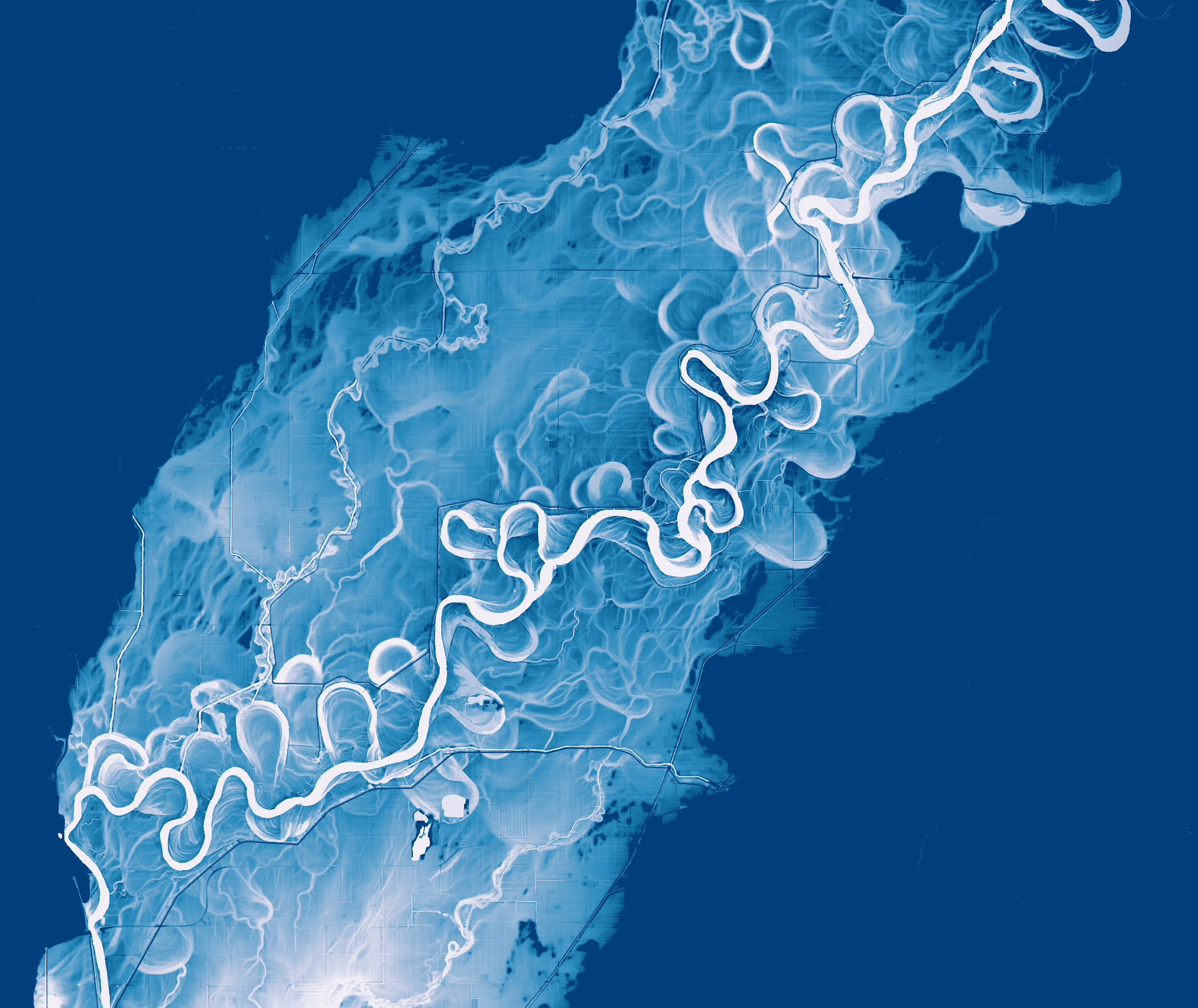
Relative elevation model (REM) of bare earth topography of the White River in southwestern Indiana made using the 2011–2013 Statewide Indiana lidar dataset. The REM highlights the river’s floodplain and its former meander paths and oxbow lakes.
The rapid increase in high-resolution lidar topography coverage around the globe demonstrates its massive utility for tasks like flood mitigation, infrastructure development, national security, conservation management, scientific research, and education. Given the considerable cost of collecting lidar data, open, web-based, and seamless access pathways are crucial to increasing the utility of the data and maximizing the return on investment. Over the past dozen years, the OpenTopography facility, funded by the National Science Foundation, has established itself as a recognized leader in the distribution of large volumes of lidar point-cloud and raster topographic data to a global community. Since it began, OpenTopography has emphasized the co-location of data alongside processing tools to give users of varying levels of expertise and computing resources on-demand access to the data and derivatives for numerous applications.
OpenTopography facilitates user-friendly access to large volumes of topography data from lidar, photogrammetry, and radar technologies. It hosts and distributes data ranging from smaller-area, user-contributed UAS (drone) photogrammetry datasets to global coverage data products like the popular NASA Shuttle Radar Topography Mission datasets. Central to the OpenTopography vision is free and open access to data co-located with user-initiated processing tools, along with educational resources to support a global community of users. The OpenTopography facility is based at the San Diego Supercomputer Center at the University of California, San Diego and is operated in collaboration with Arizona State University and UNAVCO, a non-profit, university-governed consortium.
OpenTopography has formed partnerships with academic, commercial, and governmental agencies—including Toitū Te Whenua Land Information New Zealand (LINZ) and the National Center for Airborne Laser Mapping (NCALM)—to host and provide open, web-based access to lidar data. OpenTopography currently provides access to over 41 trillion lidar points via data hosted locally or federated from public data repositories. In 2012, OpenTopography entered into a partnership with Indiana to host the state’s newly collected statewide high-resolution lidar dataset. For over a decade, OpenTopography has enabled users in Indiana, and across the globe, to quickly and easily access this data. Open and efficient access to lidar has broad impacts across sectors ranging from agriculture and infrastructure development to scientific research and education.
Almost 165,000 unique users have accessed high-resolution topographic data and derived products via the OpenTopography web portal, and close to 300,000 users have accessed topography products via its application programming interfaces. Beyond hosting data, OpenTopography provides on-demand processing tools to generate digital elevation models, topographic hillshades, slope maps, and contour lines, as well as advanced tools for hydrologic routing and for calculating topographic change from overlapping datasets. With the growing availability of state and national scale lidar datasets—in some cases with repeat coverage—OpenTopography has begun to exploit this “Big Data” for computation of high-resolution landscape change. OpenTopography’s initial exploration in this space included producing the first map of statewide topographic change, motivated in part by OpenTopography’s partnership with the state of Indiana.
Data hosting and Indiana partnership
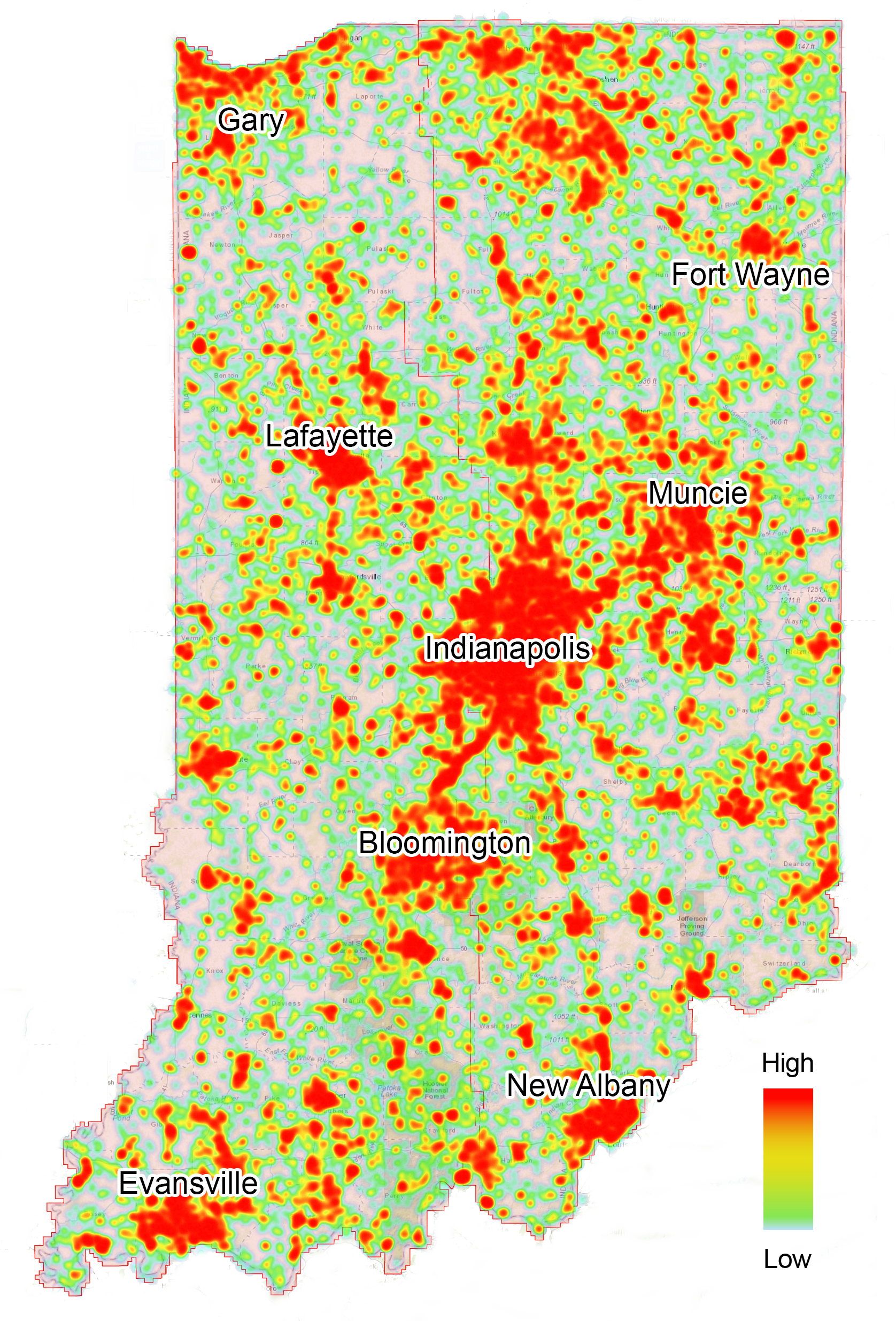
Figure 1: Usage heat map of the 2011–2013 Indiana statewide lidar point cloud on OpenTopography. Red areas indicate regions with the highest data usage.
OpenTopography has worked with the Indiana Geographic Information Council (IGIC) since 2012 to host and provide access to the 2011–2013 Indiana statewide lidar acquisition collected by IndianaMap. This continues to be the most popular and heavily used point-cloud dataset on OpenTopography. Over the lifetime of this dataset, more than 492 billion points have been processed on-demand by users via the OpenTopography portal. In addition to private and commercial sector applications, the 2011–2013 Indiana statewide lidar collection has facilitated research related to canopy height and forest structure, extracting infrastructure elements like building roofs and bridges, agricultural productivity, cellular communication systems, archaeology, and lowland meandering rivers.
“Hosting Indiana’s 2011–2013 statewide lidar collection on OpenTopography was one of the best decisions we ever made,” said Megan Compton, the Geographic Information Officer for Indiana.
OpenTopography also provides a detailed set of usage analytics to data providers. These provide not only a metric of success in terms of investments in data collection, but also insights into the data itself, including novel use cases and information helpful in planning for repeat surveys. For the Indiana lidar point-cloud data, heavy usage is particularly focused around urban areas, although data is accessed from across the entire state (Figure 1).
“Hosting our statewide lidar on OT has also resulted in several unanticipated benefits. It’s impressive to see the number of academics, students, and users worldwide who take advantage of Indiana’s seamless lidar data set for their studies, research, and projects,” said Shaun Scholer, the GIS Program Director for the State of Indiana. “An additional economic development benefit is the large number of Indiana small business users taking advantage of this service. These users are not members of what we know as Indiana’s GIS community. Still, they represent the engineers, surveyors, hydrologists, farm/agriculture service providers, planners, and construction professionals who benefit from free and easy access to this authoritative and homogenous statewide lidar dataset.”
The Indiana Geographic Information Office is in the process of moving all of its public-access GIS to the cloud to support Indiana’s next generation of the IndianaMap. Besides cloud-based storage that will support the discovery, viewing, analysis, and creation of custom maps and applications using the IndianaMap data from a standard web browser, it will also enable open, cloud-optimized streaming and geoprocessing of the newest statewide Big Data geospatial data assets. These include 6-inch pixel orthoimagery and Quality-Level-2 (QL2) lidar data stored in cloud-native formats. In addition, IGIC is planning for OpenTopography to be an essential tool for existing and new users of Indiana’s latest lidar data.
Big Data topographic differencing of Indiana
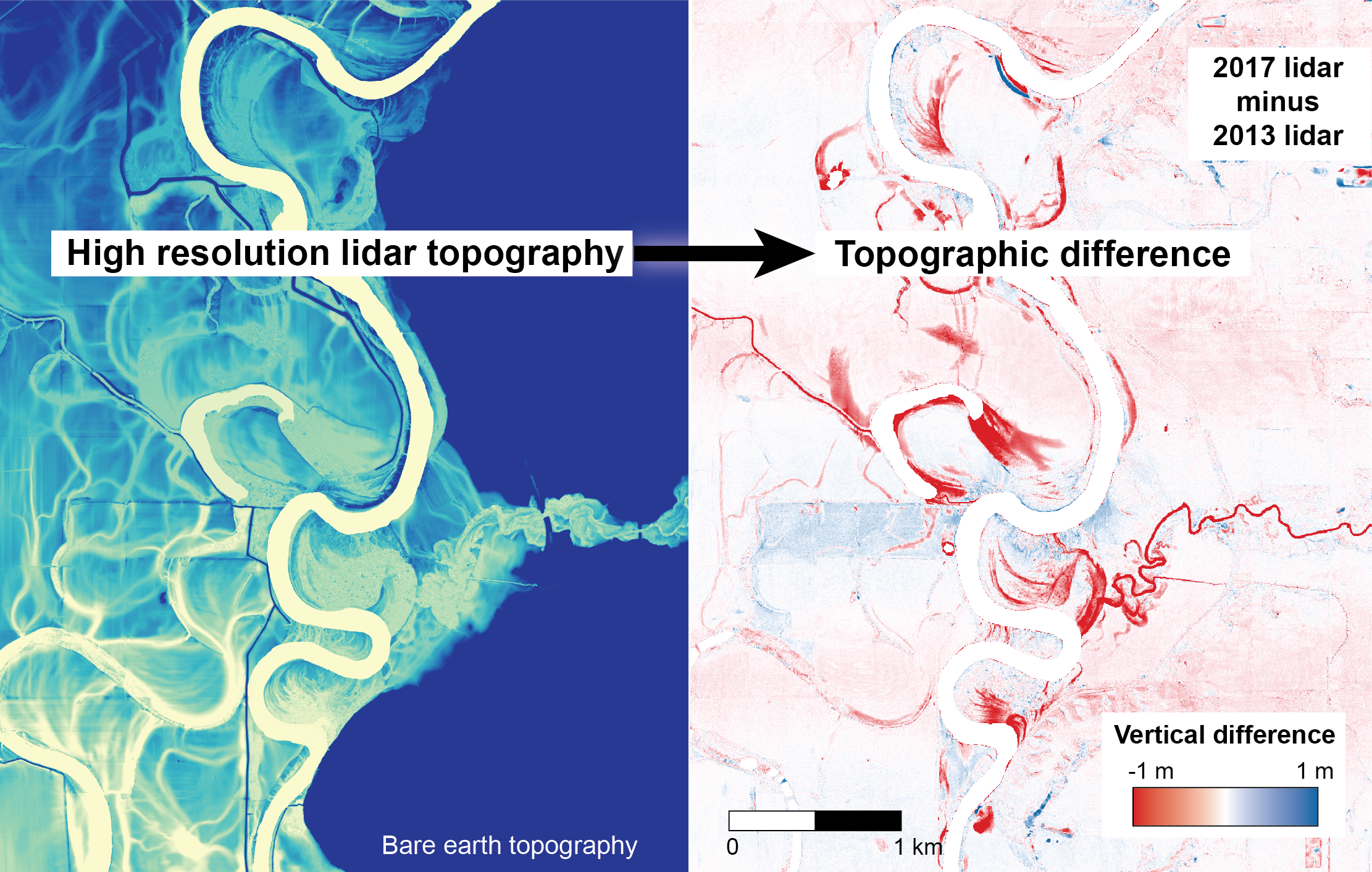
Figure 2: Topographic differencing uses high-resolution lidar topography collected from different years to determine the natural and anthropogenic vertical change at Earth’s surface.
In addition to the 2011–2013 Indiana statewide lidar coverage hosted on OpenTopography, Indiana has repeat statewide lidar coverage collected between 2016 and 2020 as part of the U.S. Geological Survey’s 3D Elevation Program (3DEP) initiative. These two datasets and Indiana’s partnership with OpenTopography presented an ideal case study to compute the first ever lidar-based map of statewide topographic change at the decadal timescale.
“Topographic differencing” uses topography datasets of the same area acquired at different times to quantify and visualize both natural and anthropogenic changes at Earth’s surface and changes in land cover over time (Figure 2). Previous studies of topographic differencing have only been conducted at the site or local scale, and this work by OpenTopography was the first to compute topographic change at the significantly larger full-state scale.
Starting from the original point-cloud datasets, OpenTopography produced one-meter-scale digital terrain and digital surface models (DTM and DSM), topographic change maps, and canopy height models over the 36,300 mi2 area of Indiana. The methods and full results of this differencing work are described in an open-access publication[1]. The resulting data products are also available in an easy-to-browse web map on OpenTopography[2]. The Indiana statewide map of vertical topographic difference reveals a variety of processes related to the agricultural, forest, river, urban, and coastal environments of Indiana that are dynamically modifying the landscape.
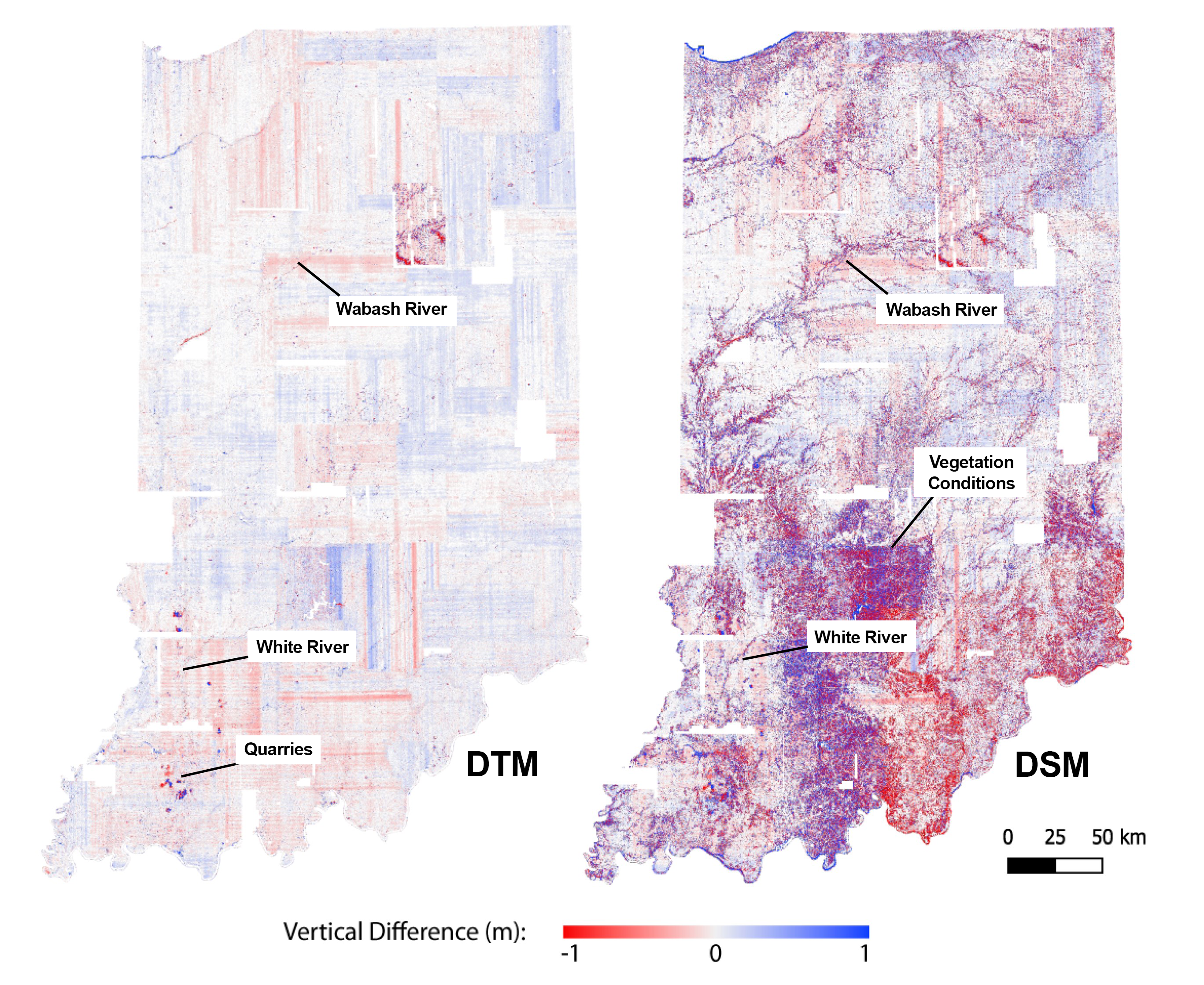
Figure 3: The differenced digital terrain model (DTM) and the differenced digital surface model (DSM) for the state of Indiana calculated from high-resolution lidar topography collected in 2011–2013 and 2016–2020. (The distinct north-south and east-west oriented lines primarily seen in the DTM do not represent change and are an artifact of positioning errors in the lidar data.)
For example, the differenced DTM and DSM reflect pronounced physical changes due to mining and quarrying near the western and southern state borders. The Wabash and White rivers create prominent change patterns stretching across the central and southern portions of the state due to fluvial, riparian, and anthropogenic activity. Color variations in the DSM change map—particularly within the south-central portion of the state—reflect the different seasons of lidar acquisitions and leaf-on versus -off conditions (Figure 3). Other notable examples of change included significant erosion along the Lake Michigan shoreline near Indiana Dunes National Park, rivers forming new meander paths and oxbow lakes, newly constructed housing developments and highway overpasses, and land-use changes related to agricultural activities. These results highlight the dynamic natural and anthropogenic changes in surface environments seen statewide over the span of a decade (Figure 4).
Outlook
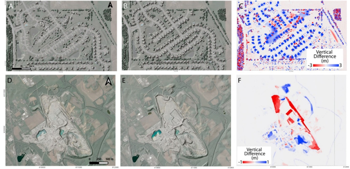
Figure 4: (A–C) A new housing development highlighted on the differenced digital surface model and (D–F) Sellersburg Stone Quarry excavation and piles near Louisville, Indiana, highlighted on the differenced digital terrain model.
The large and sustained use of the 2011–2013 statewide Indiana lidar dataset on OpenTopography illustrates the power of these datasets, and their wide reach when open, easy-to-use, online access is offered. This Indiana test case suggests that organizations funding public lidar collections should invest in, or partner with, data distribution systems designed to make data easier to access and use to achieve maximum return on investment in the data.
The statewide topographic differencing of Indiana highlights the dynamic natural and anthropogenic changes seen at the statewide scale. These Big Data approaches to topographic analyses can be crucial in monitoring natural hazards such as shoreline erosion, river flooding, and sinkhole formation, in addition to evaluating changes to infrastructure, new construction, and agricultural trends. OpenTopography has now begun applying machine learning to classify these maps of change to better discern the dominant processes and their spatial footprint. OpenTopography estimates that approximately a third of the lower 48 United States is covered by overlapping public domain lidar datasets, indicating that the OpenTopography Indiana statewide map of topographic change is feasible across much larger swaths of the US.
With large-scale processing innovations and data hosting, OpenTopography enables new discoveries and applications related to observing the Earth’s surface using high-resolution topography. OpenTopography is interested in developing new partnerships with commercial and governmental agencies to expand the reach and impact of lidar data.
Dr. Emily Zawacki is a Research Scholar at Arizona State University and works on communications, education, and outreach activities for OpenTopography.
[1] Scott, C.P., M. Beckley, M. Phan, E. Zawacki, C. Crosby, V. Nandigam and R. Arrowsmith, 2022. Statewide USGS 3DEP lidar topographic differencing applied to Indiana, USA, Remote Sensing, 14(4): 847. https://doi.org/10.3390/rs14040847.