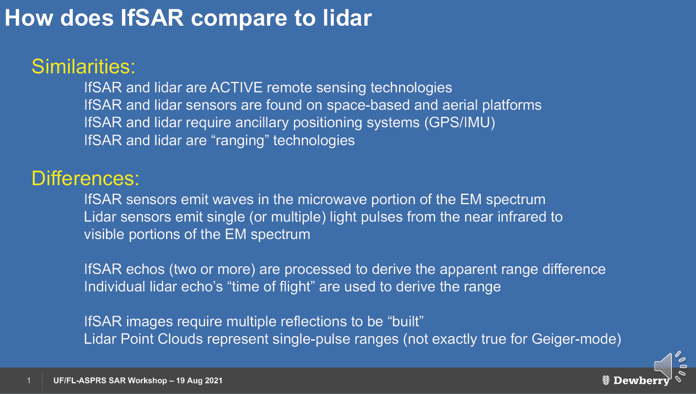
Figure 1: Introductory comparison of IfSAR and lidar.
Since 2016, the Florida Region of the American Society for Photogrammetry and Remote Sensing (FL-ASPRS), in conjunction with the Geomatics Department of the University of Florida, has been conducting bi-annual “Lidar Workshops”. While these have focused on emerging lidar technologies and applications, other remote sensing technologies have been explored—in true ASPRS fashion—including unmanned aerial sensors and electromagnetic remote sensing. After the Fall Lidar Workshop in 2020, it became apparent that there was growing interest around the state in synthetic aperture radar (SAR) for applications ranging from sea-level rise measurements and subsidence to structure maintenance.
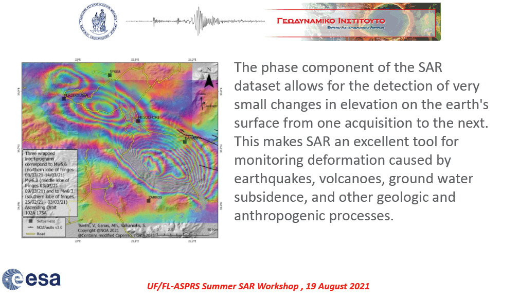
Figure 2: Introduction to the use of IfSAR to measure deformations.
Recognizing this, FL-ASPRS and the Geomatics Department at the University of Florida partnered with Dewberry, as a financial sponsor, to provide a “Special Summer SAR Workshop”, held virtually on August 19, 2021. As the goal of the workshop paralleled the goals of the lidar workshops, to highlight emerging technologies and applications, seven agencies and/or providers were solicited to make presentations. The overall focus was to highlight space-based platforms, aerial platforms and recent applications.
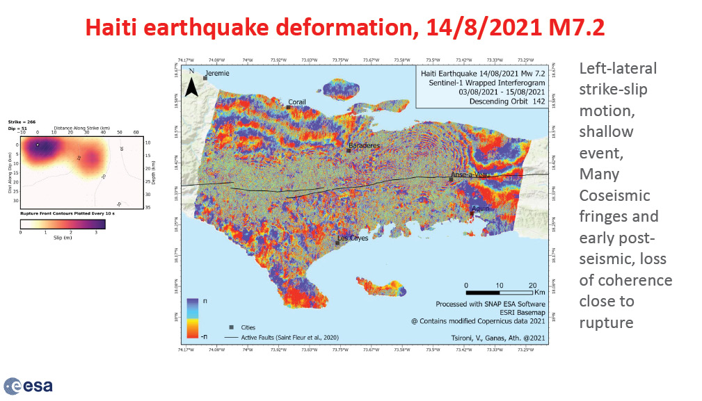
Figure 3: Deformations resulting from the Haiti earthquake of 14 August 2021, measured with IfSAR
To accomplish these goals, following a high-level introduction by Dr. Al Karlin, representing Dewberry, 20-minute presentations were made by: Dr. Athanassious Ganas, European Space Agency; Dr. Batuhan Osmanoglu, NASA/Jet Propulsion Laboratory (JPL); Chad Baker, Capella Space; Ms. Natalie Findlay, Intermap Technologies; Dr. Giacomo Falorni, TRE ALTAMiRA; Drs. Michael Tischler and Jonathan Stock, US Geological Survey (USGS); and Dr. David Maune, Dewberry. Three of these presentations are provided as full-length articles following this synopsis. The presentations were recorded and are available for review through the Online Learning Catalog at https://www.ASPRS.org.
Introduction

Figure 4: Goals of the ISRO-NASA NiSAR mission.
Dr. Karlin opened the workshop with introductions to FL-ASPRS Board members and a high-level overview of SAR. As the workshop participants were very familiar with lidar and this was the first workshop focusing on SAR, he emphasized some similarities and differences between the technologies and provided a few graphic examples (Figure 1).
The presentation concluded with an overview of the agenda, thanking the participants and recognizing Dewberry as the sponsor.
The Sentinel program
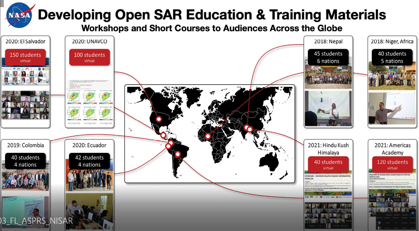
Figure 5: Open SAR educational opportunities.
Dr. Athanassious Ganas of the National Observatory of Athens Institute of Geodynamics opened the technical presentations with an overview of the Sentinel-1A and Sentinel-1B constellation and mission. He described how the C-band operates to provide resolution down to 5 m with a swath width of up to 400 km. Dr. Ganas went on to explain how interferometric synthetic aperture radar (IfSAR1) can detect small changes in elevation, which are particularly useful to measure deformations resulting from several natural processes (Figure 2).
Dr. Ganas concluded his presentation with several recent examples and applications of IfSAR (Figure 3).
The NiSAR program
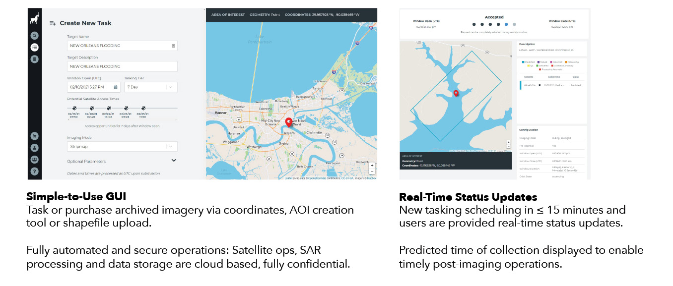
Figure 6: Capella Console.
Dr. Batuhan Osmanoglu started his presentation by introducing the collaboration between NASA/JPL and the Indian Space Research Organization to construct the NiSAR satellite (Figure 4). He continued to elaborate on the multi-faceted mission of the satellite for the dynamics of ice, ecosystems and biomass change, and solid earth deformation. He went on to discuss the characteristics of the NiSAR sensor and the probable launch date.
Dr. Osmanoglu concluded his presentation with an overview of Open SAR educational opportunities, workshops and short courses around the world through NASA/JPL (Figure 5).
Capella Space constellation

Figure 7: Intelligence questions that can be answered by SAR data from Capella Space constellation.
Chad Baker introduced Capella Space and explained how SAR can image objects that light-based technologies cannot. SAR is not affected by smoke or clouds, and can be used day or night. Mr. Baker discussed the Capella constellation, its current status and how a user could task the satellites from their desktop computer. He proceeded to a “live” demonstration of the Capella Console, the desktop satellite-tasking tool (Figure 6).
Mr. Baker followed up by discussing multiple use-cases for multi-temporal SAR and provided several examples (Figure 7).
Intermap Technologies—airborne SAR
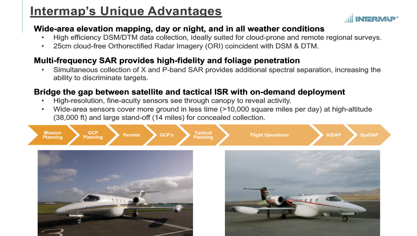
Figure 8: Advantages of airborne SAR deployed by Intermap Technologies.
Ms. Natalie Findlay introduced Intermap Technologies as a provider of remote sensing products, starting with aerial imagery more than 100 years ago. She described the unique advantages of the SAR systems installed in two aircraft that can be deployed around the world (Figure 8). She discussed the construction of IfSAR products and deliverables.
Ms. Findley described the successful use of aerial IfSAR for the USGS 3D-Elevation Program and the 10-year mapping effort with Dewberry in Alaska (Figure 9).
TRE ALTAMiRA—Sentinel applications and case studies
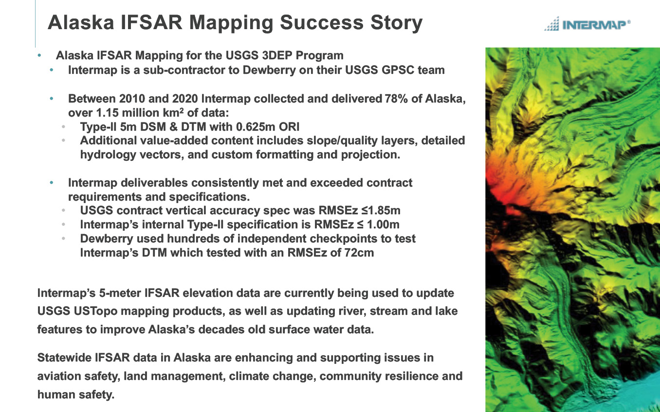
Figure 9: Intermap Technologies’ successful use of airborne IfSAR for the USGS 3D Elevation Program and the 10-year mapping effort with Dewberry in Alaska.
Dr. Giacomo Falorno recapped the basic principles of IfSAR and focused on data analysis and applications, paying particular attention to differential InSAR (DInSAR) and how phase differences can be processed into deformation maps. He then introduced a more advanced analytical technique called “SqueeSAR”, where images are stacked and a time-series created and analyzed (Figure 10).
Dr. Falorno gave several examples of recent SAR analyses. Most appropriate, at least for the workshop participants, was a time-series/SqueeSAR analysis of the recent collapse of Champlain Towers South in Surfside, Florida (Figure 11).
USGS land-level change program
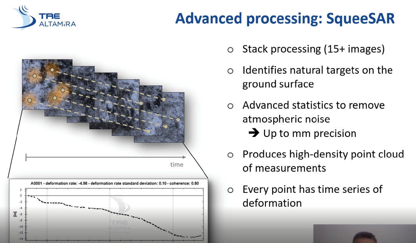
Figure 10: TRE ALTAMiRA’s SqueeSAR advanced technique, by which images are stacked and a time-series created and analyzed.
Dr. Michael Tischler introduced the USGS program to construct a “National Land-Level Change Map” and turned the presentation over to Dr. Jonathan Stock, who provided the details and discussed how a partnership between USGS, NASA, JPL and NOAA to construct the map will benefit multiple sectors of the economy. He highlighted multiple use-cases and then drew attention to the large portion of the U.S. that has not been mapped (Figure 12). Dr. Stock continued by explaining the importance of the NiSAR program to this effort and outlined the total return on investment for the program to several industries (Figure 13).
Dewberry—wrap-up and gradesheet
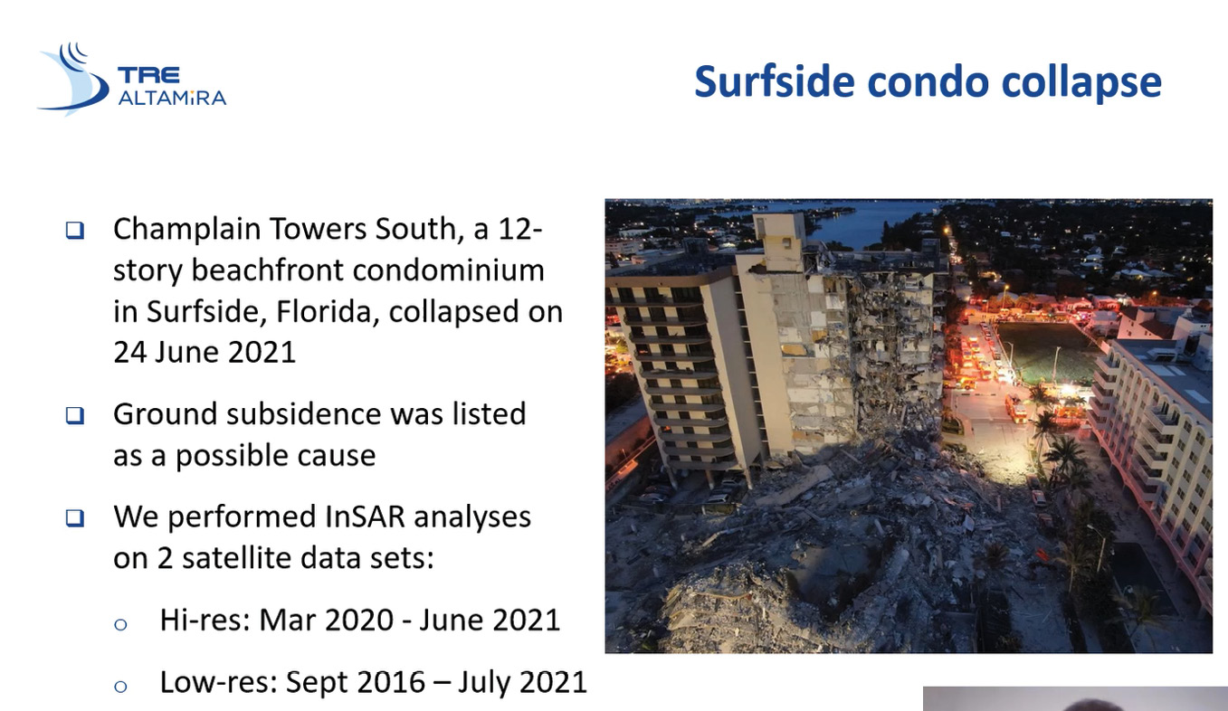
Figure 11: SqueeSAR used to investigate collapse of Champlain Towers South, Surfside, Florida.
Dr. David Maune concluded the workshop with an assessment of how multiple programs are addressing and managing subsidence through SAR, IfSAR, DInSAR, and SqueeSAR measurements (Figure 14). He emphasized how sea level rise combines with subsidence to exacerbate a bad situation, then gave eight specific examples and awarded each a “grade”.
Dr. Maune concluded his presentation with a discussion of the Sustainable Water Initiative for Tomorrow (SWIFT) Research Center in Virginia, which focuses on water treatment, replenishing of ground water and reducing land subsidence (Figure 15).
Alvan “Al” Karlin, PhD, CMS-L, GISP is a senior geospatial scientist at Dewberry, formerly from the Southwest Florida Water Management District (SWFWMD), where he managed all remote sensing and lidar projects in mapping and GIS. With Dewberry, he serves as a consultant on Florida-related lidar and imagery projects, as well as general GIS-related projects. He has a PhD in computational theoretical genetics from Miami University in Ohio. He is a past president of the Florida Region of ASPRS, an ASPRS Certified Mapping Scientist—Lidar, and a GIS Certification Institute Professional.
1 The acronyms IfSAR and InSAR are both used for interferometric synthetic aperture radar. In this issue of LIDAR Magazine, we have followed the usage of the authors of the articles.
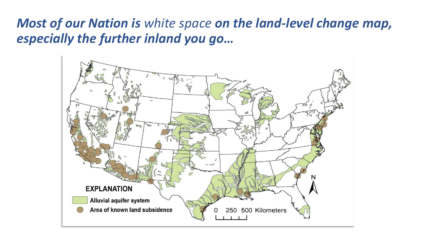
Figure 12: Land-level change has not been mapped across most of the US.
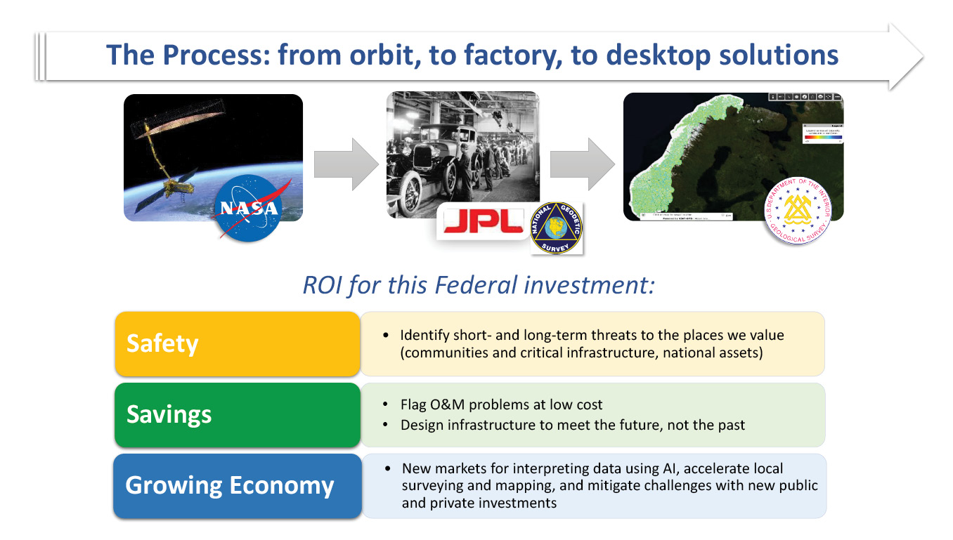
Figure 13: Process behind the NiSAR program.
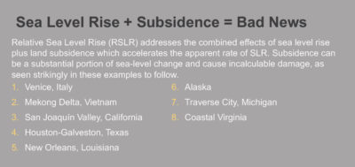
Figure 14: Case studies of sea-level rise and subsidence.

Figure 15: Sustainable Water Initiative for Tomorrow (SWIFT) water treatment project in eastern Virginia.