
Figure 1: Intermap’s Learjets are modified for long endurance and equipped with X-band IfSAR and P-band SAR sensors.
Intermap Technologies is a world leader in remote sensing and geospatial solutions, with a long history of commercial and government contract success. Leveraging high-speed, high-altitude Learjets equipped with proprietary X-band IfSAR and P-band SAR sensors, Intermap has helped more than 50 governments on every populated continent to meet their national mapping needs. Headquartered in Colorado, with offices in Prague, Jakarta, and Calgary, Intermap provides solutions to enable its partners and clients to make critical decisions affecting resource allocation, land management, environmental monitoring, public safety, and defense.
Intermap’s story began in 1919 when its predecessor, Pennsylvania Aero Service Corporation, was founded as North America’s very first aerial survey company. Organic growth and evolution with technology led to the establishment of Intermap in its current form in 1996, when the company acquired the world’s most advanced radar terrain-data collection system from DARPA. Today, Intermap operates two modified Learjet 36A aircraft equipped with advanced X-band IfSAR and P-band SAR sensors that allow for collection of wide-area elevation data and high-resolution cloud-free imagery, day or night, in any weather conditions (Figure 1).
Airborne IfSAR
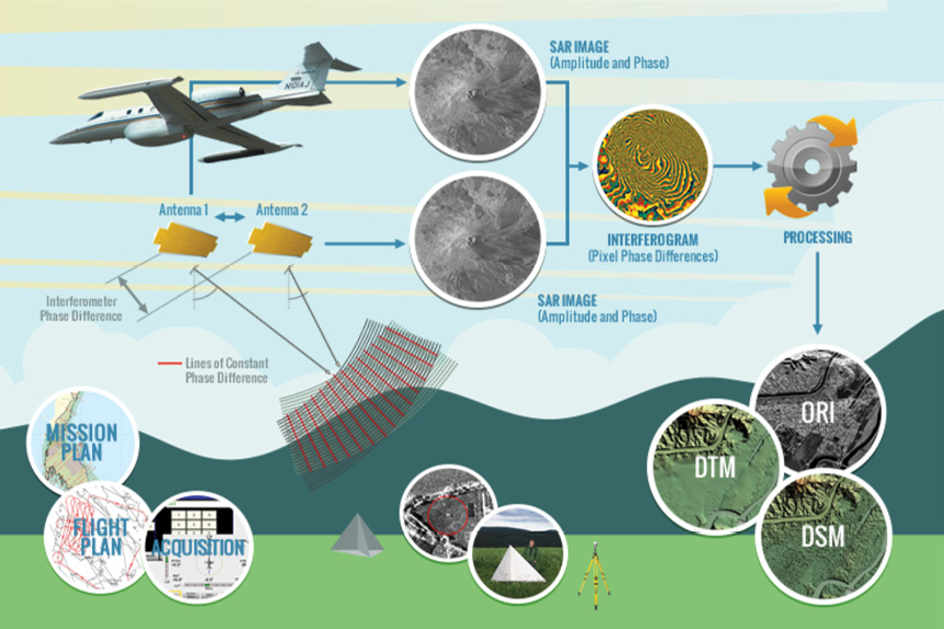
Figure 2: Conceptual diagram of IfSAR system and workflow.
Figure 2 is a conceptual diagram of Intermap’s X-band IfSAR system and processing workflow. Intermap’s X-band IfSAR systems transmit radar pulses toward the terrain, then record the reflected energy with two antennas that are precisely separated by an interferometric baseline. The two antennas simultaneously record two SAR images containing amplitude and phase of the same point on the ground—varying only by the phase difference created by the baseline between the two antennas. In addition, as the aircraft passes over the terrain, global navigation satellite system (GNSS) data and navigation data from an inertial measurement unit on board the aircraft are also collected.
The phase difference between the antennas for each image point (along with range, baseline, GNSS, and navigation data) is used to infer the precise topographic height of the terrain being imaged. This enables the creation of an interferogram (depicting the phase difference) from which Intermap’s Digital Surface Model (DSM) and Orthorectified Radar Imagery (ORI) products are derived. Through additional processing, seamless hydro-enforced bare-earth DTMs and other derived products are generated.
Airborne IfSAR core products
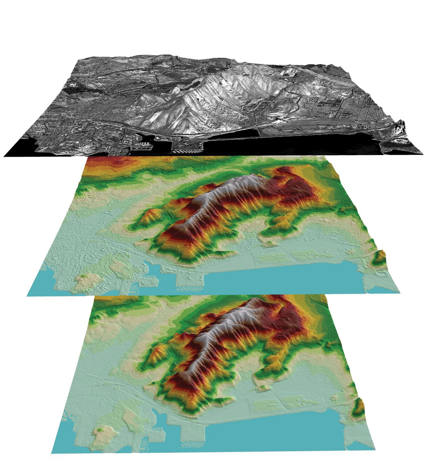
Figure 3: Intermap core products, ORI, DSM, and DTM.
Intermap generates three core products from its X-band IfSAR system: Orthorectified Radar Imagery (ORI) with up to 25 cm GSD, Digital Surface Models (DSM), and Digital Terrain Models (DTM) which are created by digitally removing all structures, objects, and vegetation from the DSM (Figure 3 and Table 1).
Intermap’s standard Type-II DSMs and DTMs have a post resolution of 5 m with better than 1.0 m RMSEZ vertical accuracy in unobstructed slopes of 0-10 degrees. Recent innovations in IfSAR processing, combined with acquisition at lower altitude (18,000 feet AGL), enable Intermap to generate native 2 m IfSAR elevation datasets with vertical accuracy of 0.5 m RMSEZ or better.
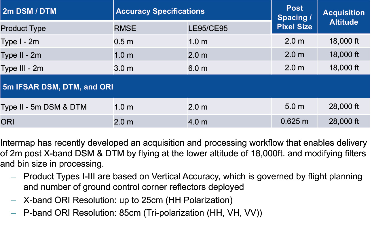
Table 1: Summary of Intermap’s standard products and their specifications.
From these core products, additional thematic layers can be derived to create full-featured topographic line maps including contours, hydrology, hill-shades, land-cover, building footprints, and roads. Wide-area IfSAR elevation data is complementary to higher resolution lidar data, which is often collected in smaller high-priority areas then fused with the wide-area IfSAR. Intermap’s 3D foundation data layers provide the framework necessary for governments and businesses to make informed decisions and find intelligent solutions to their planning and operational challenges.
In addition to X-band IfSAR, Intermap’s side-looking P-band SAR sensors allow for foliage-penetrating (FOPEN) imagery collection at altitudes up to 38,000 feet and with a stand-off distance of up to 14 nautical miles. The P-band imagery is tri-polarized (HH, VH, VV) with a pixel resolution of 85 cm, facilitating identification of a variety of phenomena including roads, trails, and objects or infrastructure otherwise obscured under dense canopy. With optimal flight planning parameters, data collection rates can exceed 10,000 square miles per sortie. Intermap’s P-band SAR imagery is delivered as 24-bit tri-colorized RGB GeoTIFF, with each polarization mapped to a single color-channel (Figure 4 see flippy or PDF).
Global experience
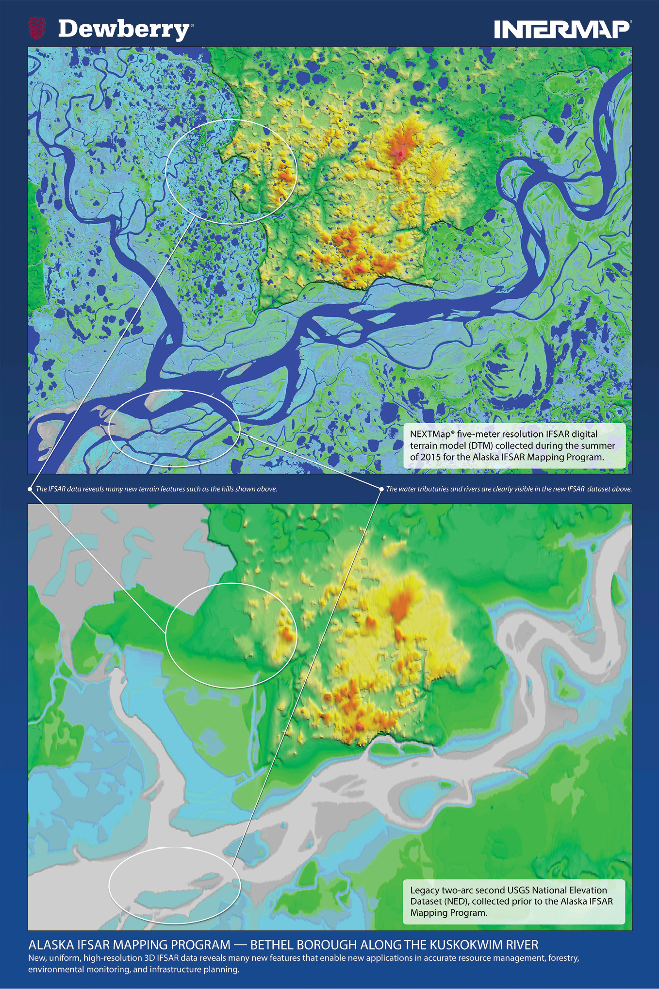
Figure 5: Intermap’s 5 m IfSAR DTM (top) shows the improvement in resolution and spatial detail compared to the 2 arc-second legacy USGS NED (bottom).
Intermap has collected more than 16 million square kilometers of IfSAR data for government projects on six continents. Clients include defense departments and national mapping agencies, as well as airport authorities and large regulated industries such as oil and gas, utilities, transportation, environmental protection, and insurance. Some major recent government projects include the U.S. Geological Survey (USGS) Alaska Mapping Initiative, Philippines national mapping program, Peninsular Malaysia mapping project for JUPEM1, and lidar fusion in Dominica.
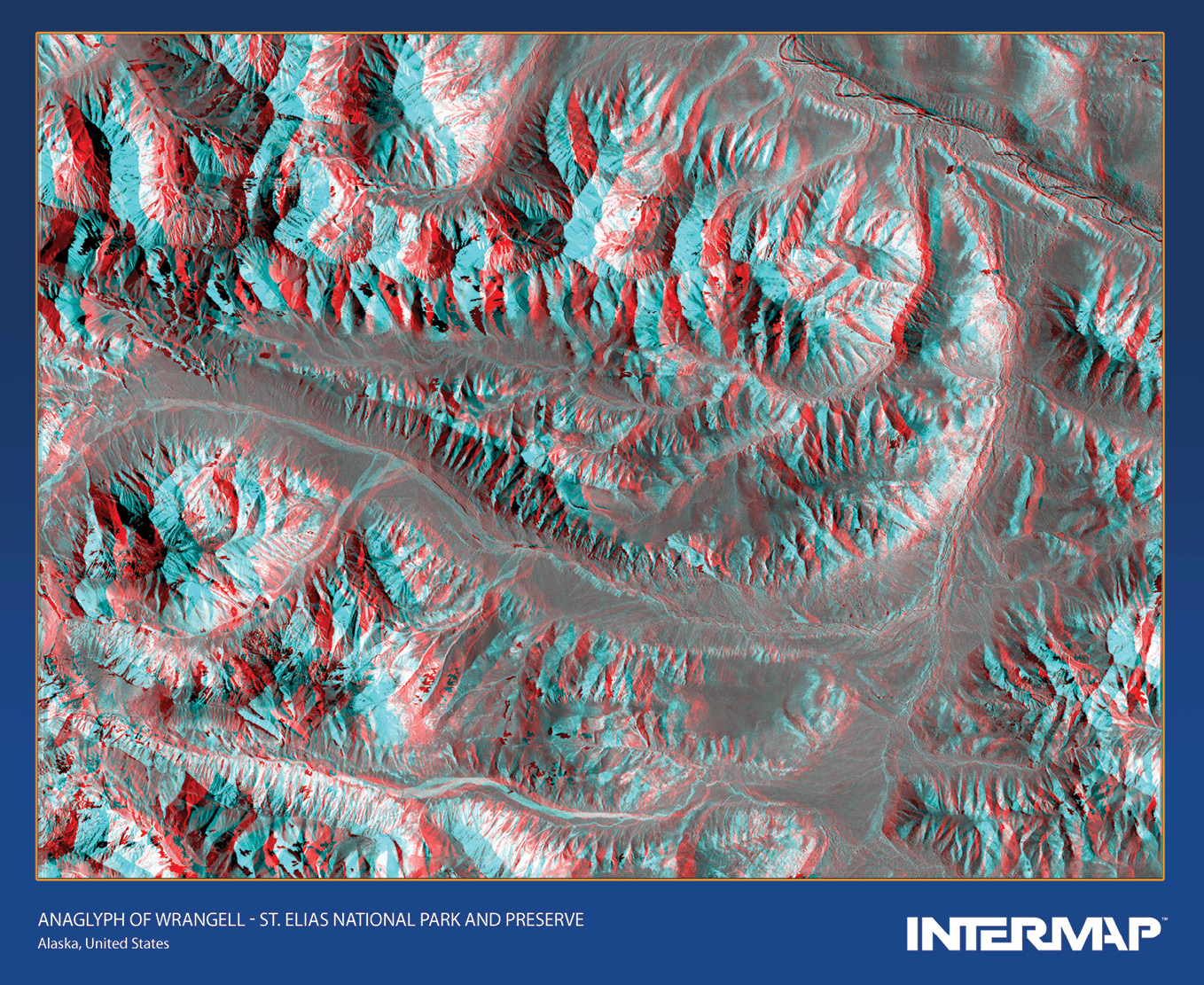
Figure 6: This IfSAR anaglyph of Wrangell–St. Elias Park and Reserve can be enjoyed by using 3D glasses.
Figure 5 demonstrates the vast improvement governments can realize when they leverage airborne IfSAR, especially in cloud-prone regions. When USGS and the state of Alaska required updated statewide elevation data, Intermap provided partner agencies with an IfSAR solution to meet their stringent accuracy requirements across the rugged, remote, and often cloud-covered state. Over the course of 10 summer-flying seasons, Intermap was tasked with collecting and delivering seamless DSMs and DTMs at 5 m post spacing, along with detailed hydrology vectors and cloud-free 62.5 cm orthorectified radar imagery. The total area collected and delivered exceeded 1,150,000 square kilometers, covering 78% of Alaskan territory, including the North Slope, the Brooks Range and the entire Aleutian island chain (Figure 6). Intermap’s deliverables consistently exceeded all contract specifications, on time and under budget, bringing Alaska’s outdated state maps up to national mapping standards. The data is now being used to improve the economy, quality of life and safety of all Alaskans, while satisfying needs for flood modeling, flight safety, environmental monitoring, and climate change adaptation in America’s last frontier.
The future
Intermap continues to invest in research and development, building new solutions, and growing its library of AI-driven algorithms, making each new solution faster, more affordable and richer in information. Intermap deploys globally, delivering products and solutions with simple and light-weight architectures, through the cloud or behind a firewall. Whether the requirements are for a national mapping program, better terrain awareness, change detection, feature extraction or predictive analytics, clients around the world can leverage Intermap to optimize their geospatial investments.
1 Jabatan Ukur dan Pemetaan Malaysia, the Department of Survey and Mapping Malaysia.