Subsidence is a gradual settling or sudden sinking of the land surface from changes that take place underground, most commonly from the extraction of water, but also by the extraction of oil and gas, or natural processes. In many locations worldwide, annual rates of subsidence are worse than annual rates of sea level rise (SLR), essentially doubling the “relative SLR” and accelerating the need for leadership.
Dewberry analyzed eight subsidence case studies, six of which used differential interferometric synthetic aperture radar (DInSAR) as a key step in the proactive management of subsidence. For each case study, Dewberry provided a report card, assigning a grade of F if communities only react to subsidence; D if they predict subsidence; C if they map annual subsidence rates and “hot spots” using DInSAR; B if they mitigate the effects of subsidence; and A if they reduce the cause of subsidence. Rather than generating controversy about whether the author’s grading system is fair or unfair, the objective of this article is to cause people to think about ways to be proactive and not just react to subsidence as though it is inevitable.
Venice, Italy
There is a race to save St. Mark’s Basilica, reached by high tides and salty floodwaters about six times per year, eroding the precious marble. During the 20th century, Venice subsided ~12 cm due to natural processes and groundwater extraction, in addition to SLR of ~11 cm. Officials put a stop to the pumping of ground water, but the city is still subsiding at a rate of 1-2 mm/year. Studies indicate that the area is also tilting ~1-2 mm/year eastward because of plate tectonics.
The $7 billion MOSE project, authorized in 2003, is an underwater fortress of steel designed to rise from the depths during high tides to protect the lagoon city of Venice1. There are 78 gates, divided into four barriers. The MOSE walls can be raised to block incoming tides. The project is expected to be completed in 2022, but may never work, because it was designed in the 1980s based on erroneously low projections for SLR and subsidence. The gates cannot be raised permanently, because the Venice lagoon uses the Adriatic as a flushing valve, and its ecosystem would be jeopardized if sealed off from the high seas. Based on current projections, the floodgates would soon need to be raised so often that they would function like a near-permanent wall, turning the lagoon into a stagnant pool for algae and waste.
The author gave a grade of B+, because scientists are considering pumping sea water deep underground to raise the city back up, including the MOSE gates. If such a project were implemented successfully, Venice could then earn an A for reducing the cause of subsidence.
Mekong Delta, Vietnam
This fertile and economically important area (Vietnam’s “rice bowl”) is subsiding at a rate of 1-4 cm/year—10 times worse than Venice—and the Vietnamese are increasingly feeling the impact: more flooding and increased salinization of groundwater and surface water. The rapidly increasing population and economic development are driving a swift increase in water consumption. The extraction of groundwater for drinking water, agriculture and fisheries is the primary cause of the dramatic land subsidence in this low-lying area.
Deltares has initiated a large-scale study of the causes and consequences of land subsidence in the Mekong Delta2. The aim is to identify the various forces driving land subsidence, establish a 3D model of the subsurface and develop a tool for predicting land subsidence. Hydrological processes and the interaction between land subsidence and the salinization of groundwater and surface water will also be covered. Maps are produced predicting the results of extraction-induced subsidence and SLR by 2030, 2050, 2080 and 2100.
The author gave a report card grade of C to the Vietnamese because they are mapping the rates of subsidence but have not yet initiated steps to mitigate the effects of subsidence/SLR.
San Joaquin Valley, California
The California Aqueduct Subsidence Program documented subsidence of over 30 feet prior to construction of the aqueduct in the 1960s3. While rates of subsidence stabilized for a few years after construction, the aqueduct has sustained an alarming and unprecedented increase in subsidence rates, e.g., ~6 inches per year since 2013, as aquifers are not replenished by rainfall or snow melt.
Deep groundwater pumping is the primary cause of this alarming trend and typically ramps up during extended droughts. The recent conversion of row crops (often fallowed in dry years) to orchards and vineyards (cannot be fallowed in dry years) has resulted in more subsidence when surface water is unavailable during dry periods. Subsidence has reduced the flow capacity of the aqueduct, and the system is becoming less reliable for the 27 million people it serves and the myriad of agricultural users that rely on its water.
The author gave a grade of C, as authorities clearly use DInSAR to map subsidence rates and “hot spots,” but nothing significant, to the author’s knowledge, is being done to mitigate the effects of subsidence other than continuing to raise the aqueduct lining and embankments and repairing structures—steps that are more reactive than proactive.
Houston-Galveston region, Texas
The Harris-Galveston Subsidence District has been tracking the effects of land subsidence for many years4; and USGS collects, processes, and interprets data on groundwater-level and aquifer-sediment-compaction to understand the effects of groundwater withdrawal on land subsidence in the region. Land subsidence is caused by compaction of fine-grained aquifer sediments (silts and clays) below the land surface due to groundwater withdrawals. This compresses the aquifer, leaving less pore space available to store water, resulting in the lowering of the land surface. Most of this compaction is irreversible: even if groundwater levels rise, compacted sediments and the associated land-surface lowering would remain as is.
Land subsidence reduces the ability to store water in aquifers; partially or completely submerges land; collapses water well casings; disrupts collector drains and irrigation ditches; alters the flow of creeks and bayous; increases the frequency and severity of flooding; and damages roadways, bridges, building foundations and other infrastructure. This is largely the reason why the Houston-Galveston area has flooded more frequently and severely in recent years.
Groundwater withdrawn from aquifers has been the primary source of water for municipal supply, commercial and industrial use and irrigation in the region since the early 1990s. Since 1975, subsidence districts have routinely regulated and reduced groundwater withdrawals, but they have increased as urban growth has spread throughout the area and subsidence of over 2 cm/year is still occurring, roughly comparable to subsidence rates in the Mekong Delta.
The author gave a grade of B- to the district. Authorities have used DInSAR to map subsidence rates; Subsidence Districts have regulated groundwater withdrawals; and Galveston is building expensive levees and floodwalls to combat the long-term effects of climate change, SLR and subsidence.
New Orleans, Louisiana
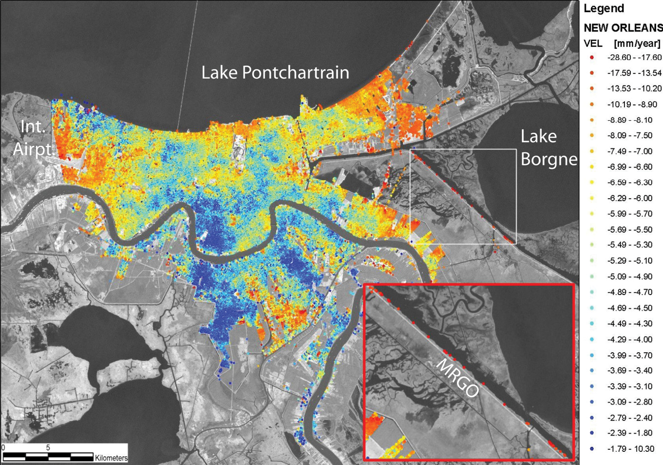
Figure 1: NASA uses DInSAR to map land subsidence rates in New Orleans.
It has long been known that New Orleans is sinking, and human causes of subsidence are routinely reported. NASA and JPL regularly use DInSAR to map subsidence rates and “hot spots” in New Orleans (Figure 1). The city has built numerous structural solutions and has extensive hazard mitigation plans for dealing with subsidence: projects include prevention, natural resource protection, public education and awareness, and property protection with voluntary incentives.
The author gave a grade of B to New Orleans as authorities clearly use DInSAR to map subsidence rates and “hot spots,” and have been proactive with mitigation strategies.
Alaska
The state has significant subsidence in some areas, especially where permafrost is melting, and significant uplift in other areas from post-glacial rebound caused by the lessening weight of glaciers as they melt. Alaskans have used GNSS at specific locations to map subsidence and uplift, but only recently has DInSAR been considered to map subsidence/uplift rates. The author gave Alaska a grade of C-, because it is not systematically mapping subsidence and uplift, relying only on repeat GNSS observations at specific locations throughout the state.
Traverse City, Michigan
Traverse City has experienced three feet of classic scour beneath its river wall, leading to subsidence on the landward side. The city established criteria for evaluation of alternatives and its Unified Plan shows environmental priorities, including shifting the balance towards habitat and nature over human recreation and economic development. Because the Unified Plan’s priorities include mitigation to restore the natural river corridor, but because the city has not yet decided to adopt the plan, a grade of B- was awarded.
Hampton Roads, Virginia
Under contract to the National Geodetic Survey in 2017, Dewberry and TRE ALTAMiRA used DInSAR, working with a six-year data stack of Cosmo-SkyMed SAR imagery, to map subsidence for the Hampton Roads area of Virginia. Subsidence averaged ~1 mm/year, but subsidence “hot spots” were as much as -2.76 inches (70 mm) on a taxiway at the Norfolk Naval Air Station over the six-year period. For mitigation purposes, Dewberry provided the framework for Virginia Coastal Resilience Master Planning and developed the Sea Level Wise adaptation strategy for Virginia Beach to enable the city to adapt to changing environmental conditions, but those steps could only warrant a grade of B.
Earning a grade of A, the Hampton Roads Sanitation District (HRSD) Sustainable Water Initiative for Tomorrow (SWIFT)5 is slowing the rate of land subsidence in the Hampton Roads area in addition to stabilizing and restoring the water supply in the Potomac aquifer. USGS estimated that groundwater withdrawals are responsible for more than half of the land subsidence in Hampton Roads, and land subsidence contributes more than half of the net effect of SLR. A reduction or complete halt of subsidence would provide years of added use of highly valuable developed land impacted by subsidence and SLR and protect thousands of acres of environmentally valuable wetlands from complete inundation.
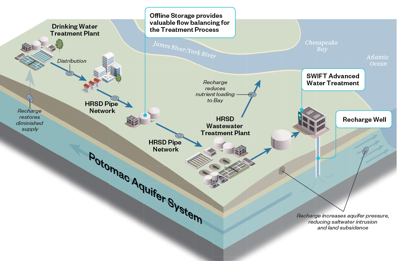
Figure 2: SWIFT is an innovative water treatment initiative in eastern Virginia to ensure a sustainable source of groundwater while addressing sea level rise, subsidence and saltwater intrusion.
SWIFT takes highly treated water that would otherwise be discharged into the Elizabeth, James or York rivers and puts it through additional rounds of advanced water treatment to meet drinking water quality standards (Figure 2). SWIFT water is then added to the Potomac Aquifer, the primary source of groundwater throughout the area. When HRSD’s five main plants are operational, SWIFT will replenish the Potomac Aquifer with 100 million gallons of purified drinking water daily. USGS has installed an extensometer at the SWIFT Research Center to help geologists measure SWIFT’s progress at replenishing the groundwater and reducing land subsidence.
When all five major plants are operational, a grade of A+ is possible if a new DInSAR analysis is performed to prove SWIFT’s reversal of historical subsidence trends in the area.
The lessons learned from SWIFT technology could potentially benefit Venice, the Mekong Delta, the Central Valley of California, Houston-Galveston, New Orleans, the state of Florida and many other areas with similar challenges from subsidence, SLR and saltwater intrusion.
Endnote
Rather than debating whether the report card grades discussed here are fair, the author hopes this paper will cause managers to think about whether they are doing everything they can to be truly proactive in addressing the combined threats of SLR, subsidence, and saltwater intrusion. DInSAR can provide metrics for defining an area’s subsidence problem, but it takes leadership to mitigate the effects of subsidence and reduce its cause by proactively managing subsidence.
1 en.wikipedia.org/wiki/MOSE