 In conjunction with GeoWeek 2022, we’ve opted to celebrate the accomplishments of leaders in our field at the Lidar Leader Awards, a joint initiative of LIDAR Magazine and the organizers of the International LiDAR Mapping Forum (ILMF). Over the pages that follow, we’ve highlighted some of the finalists from each award category. As you’ll find, the nominations embody a galaxy of lidar talent. All winners will be provided the opportunity to highlight their perspectives in an upcoming edition of the magazine.
Five categories were offered this year:
Outstanding Personal Achievement in Lidar
Outstanding Team Achievement in Lidar (2-99 members)
Outstanding Enterprise Achievement in Lidar (groups of 100+)
Outstanding Innovation in Lidar
This category was created to honor recent projects or products that appear to be ground-breaking.
Outstanding University Achievement in Lidar
This category is open to all universities, students and teams within the university, who must demonstrate an exceptional achievement within the realm of lidar technology.
Editor’s note: The text that follows has been excerpted from original nominations and in no way defines the views or opinions of the award committee, the organizers of ILMF or LIDAR Magazine. Some text has been edited for clarity and length.
Congratulations to this year’s winners:
Personal Achievement in Lidar
Dr. Martin Isenburg (1972-2021)

 Dr. Isenburg was the creator of the widely used LAStools, LASzip, and PulseWaves software packages, and he operated Rapidlasso GmbH while providing commercial and open-source software for lidar data processing, exploitation, compression, and organization. Martin was a vocal advocate for the release of public scan data. He frequently gifted his software tools to groups through the “LASMoons” program to allow students and organizations to use LAStools to achieve specific academic and ecological lidar data processing tasks. Not only did this program show users how to effectively use the software, it demonstrated the worldwide thirst for lidar data acquisition, processing, and compression.
Team Achievement in Lidar
Minnesota 3DGeomatics Committee
![]() Minnesota was an early adopter and national leader for statewide lidar technology, affording a unique understanding of the ongoing need for higher data quality. The 3D Geomatics Committee (3DGeo) of the Minnesota Geospatial Advisory Council works to identify and promote the need for planning, funding, acquisition, and management of three-dimensional geomatic data and derived products, such as lidar. Geomatics is the discipline of gathering, storing, processing, and delivering spatially referenced geographic information. The 3DGeo Committee engages multiple disciplines in Minnesota to promote the value, importance, and use of this complex and voluminous three-dimensional information.
Minnesota was an early adopter and national leader for statewide lidar technology, affording a unique understanding of the ongoing need for higher data quality. The 3D Geomatics Committee (3DGeo) of the Minnesota Geospatial Advisory Council works to identify and promote the need for planning, funding, acquisition, and management of three-dimensional geomatic data and derived products, such as lidar. Geomatics is the discipline of gathering, storing, processing, and delivering spatially referenced geographic information. The 3DGeo Committee engages multiple disciplines in Minnesota to promote the value, importance, and use of this complex and voluminous three-dimensional information.
Outstanding Enterprise Achievement
Augmented LiDAR Box by Outsight
 Outsight develops real-time 3D LiDAR perception solutions.
 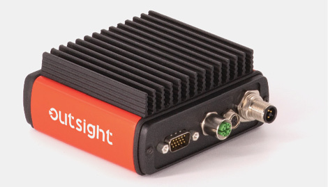 Our mission is to make LiDAR-based Spatial Intelligence become Plug & Play, so it can be used by application developers and integrators in any market. The Augmented LiDAR Box is the first LiDAR pre-processor: a real-time software engine that turns any LiDAR into a Spatial Intelligence device. It overcomes the complexity of using RAW 3D data, so any application developer or integrator can efficiently use LiDAR in its own solutions without needing to become a 3D LiDAR expert.
Outstanding Commercial Innovation
Hovermap by Emesent

![]() Founded in 2018, Emesent is a world-leader in drone autonomy, LiDAR mapping, and data analytics. Emesent’s Hovermap is a smart mobile lidar scanning unit that can be mounted to a backpack, vehicle, or drone to quickly map complex environments. When mounted to a drone, Hovermap also provides collision avoidance and autonomy to map inaccessible or GPS-denied areas. It is equally capable above ground, under bridges, or up close to critical infrastructure. Hovermap’s accurate, high-resolution point clouds can be easily processed into CAD-ready datasets to build 3D models using industry standard tools, such as PointCab, PointFuse, or Revit/AutoCAD.
Founded in 2018, Emesent is a world-leader in drone autonomy, LiDAR mapping, and data analytics. Emesent’s Hovermap is a smart mobile lidar scanning unit that can be mounted to a backpack, vehicle, or drone to quickly map complex environments. When mounted to a drone, Hovermap also provides collision avoidance and autonomy to map inaccessible or GPS-denied areas. It is equally capable above ground, under bridges, or up close to critical infrastructure. Hovermap’s accurate, high-resolution point clouds can be easily processed into CAD-ready datasets to build 3D models using industry standard tools, such as PointCab, PointFuse, or Revit/AutoCAD.