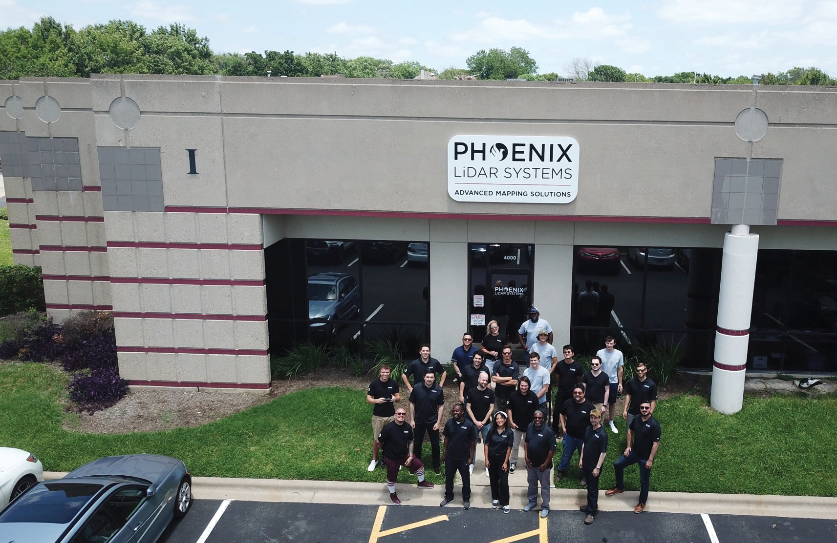
Phoenix team outside its new headquarters in Austin, Texas.
Nine years ago Phoenix LiDAR Systems introduced commercial drone lidar to the market, in what is now a global industry. The company boasts an impressive list of industry firsts over the years. In 2013, it launched the first real-time 3D point-cloud visualizer that helped reduce data acquisition errors in the field. Just two years later it developed the first fixed-wing UAV with lidar integration. The need to increase both range and speed, and to improve the protection of lidar equipment from rough landings, led Phoenix to create the first VTOL fixed-wing UAV-lidar system in 2016. In a remarkable year of innovation, it launched in 2017 the formation of the first real-time 3D point cloud with RGB fusion, the first cloud-based lidar post-processing platform, and the first UAV flight-planner tool. Phoenix has proven itself to be an innovator and an established leader in commercial UAV-lidar systems.
 As innovation continued to expand, both in lidar technology and software for streamlined data acquisition, Phoenix realized it had outgrown its facility in Palms neighborhood in Los Angeles. With plans for a larger, more centralized location better suited to its growing success, Phoenix decided to relocate to the rapidly growing metropolitan city of Austin, Texas.
Relocation

Screenshot from PC Master, showing flight lines and lidar coverage.
Phoenix is delighted to have moved to Austin. The genesis of Phoenix and the experiences fostered in California allowed the company to open up the industry, and create a framework for others to follow. Since those first innovations, the lidar market has exploded, and it was apparent that the next phase would require new ideas, a ‘tech-forward community’, and the physical space to accommodate growth. The relocation has afforded Phoenix these competitive advantages. Though now officially Texan, the company has retained much of its California ‘style’ and a belief that forward-thinking solutions combined with a diverse team of top talent is the most important strategy for growth. The team has developed an ‘open door’ policy at the Austin headquarters, and welcomes customers and friends to visit and see the latest ideas in action.
Lidar market
The lidar drone market is growing significantly, which can be attributed to the increasing number of end-users across many different applications. According to a market analysis by Mordor Intelligence, the UAV-lidar market was valued at $74.96m in 2020 and is projected to reach a value of $525.86m by 2026. The growing requirement for data acquisition and surveillance is also predicted to drive the market forward. With the demand for UAV-lidar becoming increasingly more widespread among different industries, it is surprising that more companies are not choosing to utilize this technology. One reason is premium pricing. Highly advanced remote sensing technology is known to come with a high price tag, which is the primary factor limiting its full growth potential. Phoenix has sought to find a solution to appeal to more price-conscious customers searching for a powerful UAV-lidar solution.
Cost-effective lidar solution
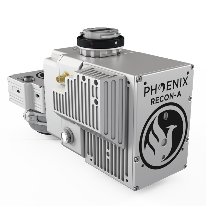
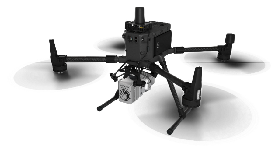
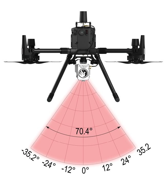
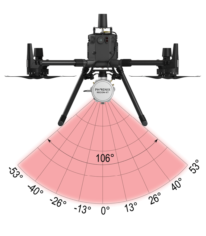
RECON-A, shown here with Livox Avia: system mounted on DJI M300; close-up of lidar sensor as integrated by Phoenix; left, horizontal lidar field of view.
 Phoenix, therefore, decided to develop a product series that could broaden the global audience of lidar sensor users. The goal was to build cost-effective lidar solutions that could provide lifetime value and flexibility for customers. Thus the RECON series was born.
The intention is to expand the global lidar mapping market, through education and lower barriers to entry. The RECON series provides a user-friendly experience at a lower price point, enabling more businesses and individuals to become involved in using aerial lidar. Phoenix hopes that cost-effective hardware paired with intuitive workflows will enable more customers to take the leap into lidar.
Phoenix aims to minimize bloated costs and overhead, passing the savings on to customers to provide them with a no-frills lidar experience. The desire is to democratize lidar for new and inexperienced customers, opening new doors and making the industry larger overall. This is achieved by cutting out nice-to-have features from legacy systems, leaving only raw lidar performance.
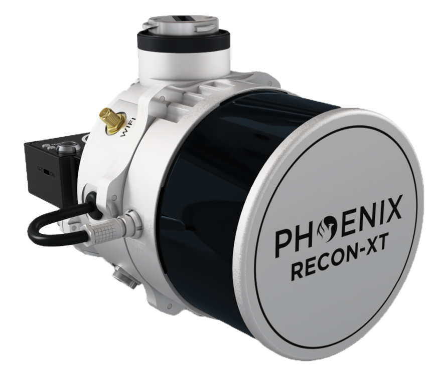
RECON-XT, shown here with Hesai PandarXT, system mounted on DJI M300 below; close-up of lidar sensor as integrated by Phoenix above; left, horizontal lidar field of view.
 Emphasis was placed on trimming the premium features of current solutions, retaining the high performance. The RECON series does not sacrifice high-quality scanning, but simply offers the most lightweight, flexible options at a price point that brings value to the end user. This process involved removing some of the premium features of the SCOUT and RANGER series. Technical changes were made to minimize weight and profile of the RECON series so that it would fly efficiently on the DJI M300. Cost of operations and costs per acre scanned were reduced by optimizing the acquisition process and simplifying the workflow to the point where in-person training is not needed. The simplicity of acquiring and processing data from the RECON series has revolutionized the Phoenix workflow and passed the benefits to customers. The goal is to help customers save, not just on up-front costs, but on training and operations costs over its lifetime.
 The Livox Avia and Hesai PandarXT sensors were extensively tested and proved to be valuable and cost-effective. Phoenix found them to stand out in their class from a performance and value perspective. The company chose to move forward, integrating these sensors into the RECON series.
Changes to the PLS workflow
Phoenix has introduced a complementary software package that is extremely lightweight and efficient. PCMaster Suite allows the end-user to fuse and colorize point-cloud data, provides a straightforward workflow for LAS export and easily integrates with their own workflow for specific use-cases. PCMaster Suite embodies a truly simplified, one-click workflow and removes the training headaches. Users can process trajectory and lidar data together with minimal steps, producing a LAS file with ease.
Flexibility options

Detailed capture of distribution utility lines over a corridor of dense vegetation. Captured by RECON-A.
The RECON series comprises two models. RECON-XT can be mounted to any vehicle, land, sea or UAV, resulting in a lightweight lidar solution that can accomplish any job. The RECON-A is designed for mounting on a DJI Enterprise Series UAV. The RECON units can be powered from the auxiliary power port, making them agnostic to the vehicle used to capture data. Using the GUI, users can stop and start recording wirelessly from their mobile device. This facilitates control of the unit from anywhere, even if it is not accessible during data acquisition. RECON units record on to external USB storage and can accept a number of USB 3.0 devices. Thus there are no storage limitations during data capture, as adding more storage is as simple as plugging in another empty USB drive.
For UAV flying, the RECON Series was designed for DJI enterprise drones such as the M300 and M200 series. The RECON series is natively compatible with the DJI Skyport interface on the Matrice aircraft: power will be provided to the payload through the Skyport, making setting up and tearing down faster and reducing time spent in the field. Thus the RECON series is ready to fly on any DJI enterprise drone, with a maximum flight time on the M300 of 35 minutes. Thanks to its auxiliary power port, any vehicle can carry the RECON series and Phoenix has ensured that integration will be possible with a number of vehicles. The mission-planning portion of the workflow is done inside Phoenix Flight Planner, which is web-based service software to calculate flight plan, review estimated lidar data quality, and upload a terrain-following KMZ directly to the UAV before flight. The tool allows missions to be exported to a number of flight applications and aircraft.
Use cases
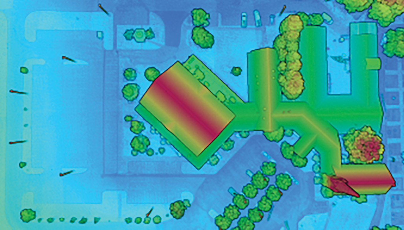
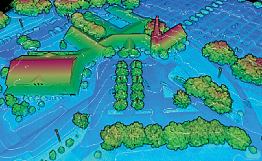
Dense UAV-lidar mapping dataset, symbolized by height and intensity, with smoothed contours overlaid. Captured by RECON-XT.
The RECON models are both quality, budget-focused systems, but they do have individual characteristics. The RECON-A is excellent for UAV -scanning of power lines as its optional laser pattern facilitates high-density scans on low-reflectance transmission lines. The RECON-A offers two scanning pattern options. The user can select repetitive-line scanning where the laser simply moves back and forth horizontally to capture the highest precision data, while reducing noise and point cloud file size. Users also have the ability to utilize the optional non-repetitive scanning mode, in which the laser forms a star-like pattern and optimizes the sensor’s abilities to pick up very small, low-reflectance targets such as dark power transmission lines. It also excels in the surveying of towers. The RECON-A is the most cost-effective system Phoenix has offered.
 The RECON-XT includes an auxiliary mount, combined with its 360° laser, so it can be adapted for use in mobile or backpack scanning. Thanks to versatility and low cost, capturing data from a mobile or backpack scanning mission is possible at a fraction of the cost of more traditional lidar systems. The RECON-XT is the most value-oriented system Phoenix offers, with a very low barrier to entry, so it fits survey firms, and businesses alike. The system’s well-rounded abilities suit it to many different applications, including penetration of vegetation, open-pit mining, glacier surveying and monitoring.
Unlimited support
Phoenix offers its new CARE service program, an annual service offering unlimited support on the RECON series. In addition, customers are granted full access to training video series, supporting documentation and the Phoenix Flight Planner tool. Phoenix is dedicated to ensuring the success of customers. The CARE program is designed to support the RECON systems and customers. Each RECON system comes with one year of CARE, with options for annual subscription renewal, up to a total of three years.
Future of RECON
Phoenix plans to add several accessories and features to the RECON portfolio. Development of georeferenced photogrammetry is under way, as well as backpack and roof-rack accessories for the RECON series. The company is exploring further optimization of the workflow and how to increase the lifetime value for customers.
The excitement about the cost-effective RECON series is evident and Phoenix has taken steps to ensure customers can bring RECON units fully into its software environment. Full compatibility with LiDARMill, a cloud-based processing suite designed to make processing and managing point-cloud data very simple, is under development. PCMaster is a fine tool for customers seeking a simple workflow, but LiDARMill is an all-inclusive service that will processes data in an automated manner and allows users to store their point clouds online, protected by the cloud. This is key to disseminating information to members of customers’ teams. LiDARMill Viewer gives anyone access to the point cloud in a browser window. The barrier to entry for lidar data analysis has been reinvented by LiDARMill and the intent is to bring this complete solution to market.
The RECON series was developed as a direct result of changing market conditions, including promising new sensors and upgrades to Phoenix’s navbox and camera. The RECON series will retain its goal of cost-effectiveness, and ease of use, but the company will strive to deliver the best solutions to customers during these rapidly changing times in the world of technology.
Conclusion
The lidar world is evolving so rapidly that the last two or three years have seen more innovation than the preceding decade. Previously second-rate “automotive” class sensors have become so advanced that they are being increasingly used for mapping purposes. Lidar data has become more democratized with the expansion of cloud-based services for processing and hosting point cloud data.
Phoenix hopes that lidar will become increasingly more affordable and easier to use. These benefits should expand the market as a whole and increase the number of use cases for lidar systems, enabling even more of our world to be captured using lidar.
Abigail Chew is the global marketing coordinator at Phoenix LiDAR Systems. She graduated in 2020 with degrees in both marketing and sales from the Perdue School of Business. Highly motivated and career-driven, Abigail has experience working in b2b sales and marketing, event planning, brand promotion, media analytics, and managing contemporary digital tools, platforms, and channels. When she is not producing various types of content to expand Phoenix’s digital footprint, Abigail works with the sales team to implement new strategies and tactics to continue growing the company’s global presence within the commercial lidar drone industry.