What do you do when you need a specific technology that doesn’t yet exist? You build it.
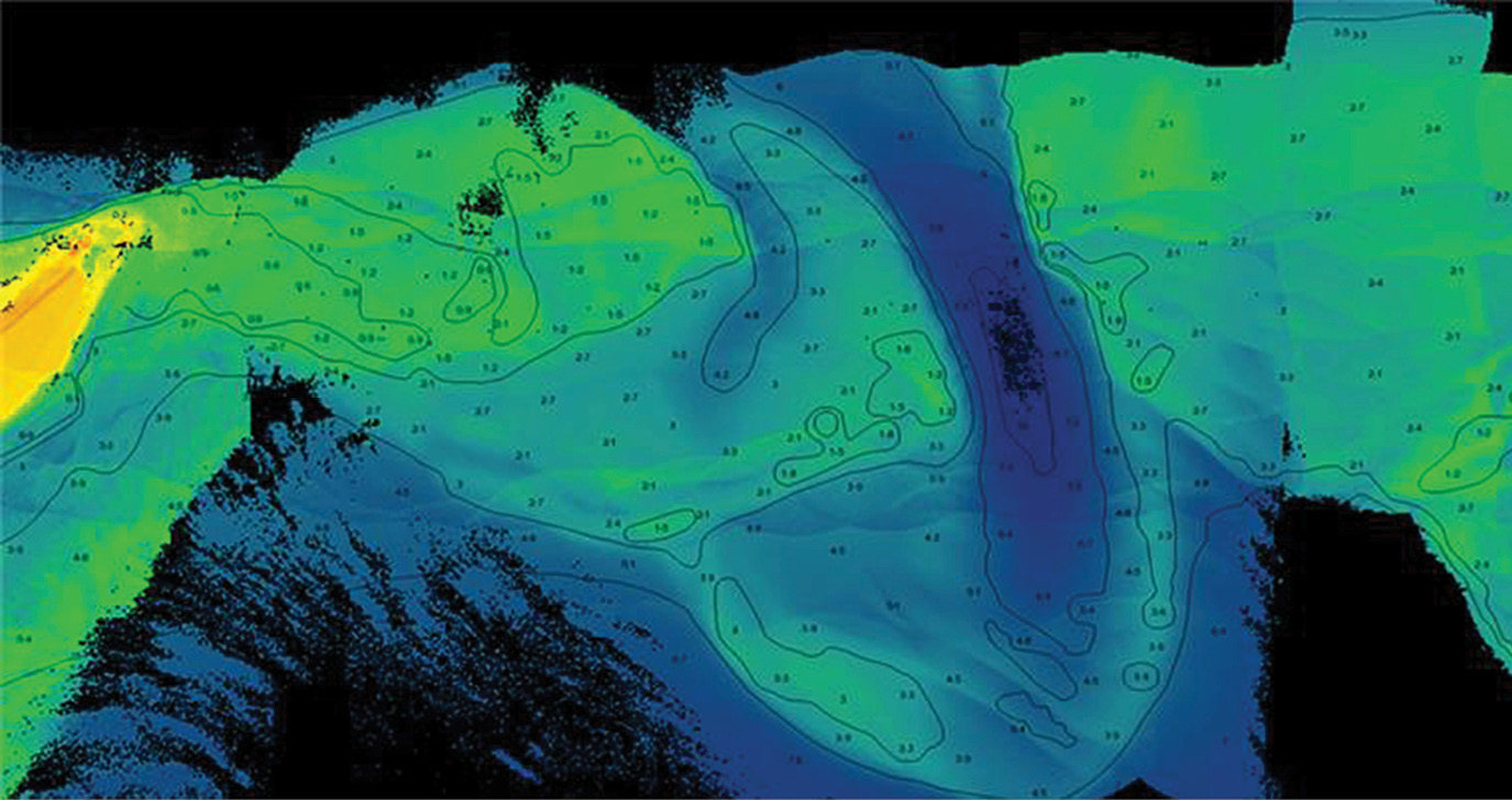
This was one of the first engineering flight bathymetric datasets collected via BULLDOG on March 22, 2021. It shows Little Dog Key Pass in the Mississippi Sound, with charted depths and contours overlaid for comparison. Image courtesy of USACE/JALBTCX.
The project to build the Bathymetric Unmanned Littoral LiDar for Operational GEOINT (BULLDOG) sensor started when Woolpert was asked a basic tactical question: how high can you fly and still collect lidar bathymetry?
To answer this, Woolpert, a geospatial firm more known for its lidar data collections than its sensor development, established a research and development lab in Mississippi and assembled a team of experts from a wide variety of disciplines—from physicists and computer scientists to mechanical and electrical systems engineers. The team worked through initial designs, lab experimentation and field trials; navigated engineering and integration challenges; and conducted test flights throughout 2019, 2020 and early 2021. The result was a topographic and bathymetric lidar sensor that would fly higher with a broader swath and could collect data faster than other currently operating topobathymetric lidar systems.
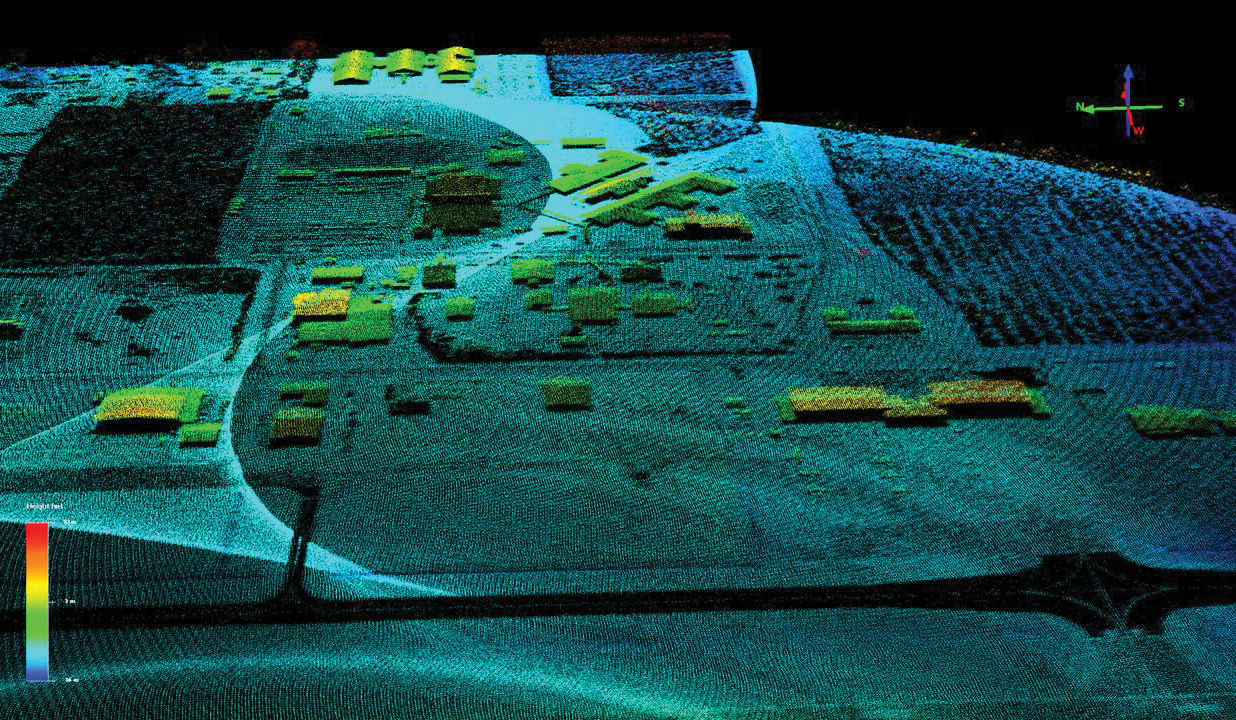
This topographic point cloud was generated with BULLDOG’s Geiger-mode avalanche photodiode (GmAPD) sensor from an elevation of 10,000 feet over Stennis International Airport in Kiln, Mississippi. The GmAPD sensor is a multi-pixel array (32×128) capable of precise single-photon time-of-flight detection. Image courtesy of USACE/JALBTCX.
“Currently, with the bathymetric lidar sensors that are on the market today, to survey and map a coastline, you have to fly multiple parallel flight lines to get complete coverage of the coast,” Woolpert Vice President Mark Smits said. “What we want to bring to the table is to be able to fly a coastline and get a good characterization of it in a single pass. So, with a broader swath and flying at higher altitudes, we can potentially map out coastlines faster, more efficiently and more safely due to the heightened elevation over challenging terrain. There is no other system like this on the market, because to do that is extremely challenging.”
Jennifer M. Wozencraft is the director of the Joint Airborne Lidar Bathymetry Technical Center of Expertise (JALBTCX), which contracted with Woolpert for BULLDOG. Wozencraft said that flying at higher altitudes and collecting topographic and bathymetric lidar data simultaneously will help address the increasing need for topobathymetric data around the world. JALBTCX performs operations, research, and development in airborne lidar bathymetry and complementary airborne coastal mapping technologies to support the U.S. Army Corps of Engineers (USACE), the U.S. Naval Meteorology and Oceanography Command, the National Oceanic and Atmospheric Administration (NOAA) and the United States Geological Survey (USGS).
“The higher a topo-bathy lidar sensor can fly while collecting accurate data, the faster information can be collected to meet requirements for coastal engineering, science and nautical charting,” Wozencraft said. “This data helps our agencies maintain the coastal marine transportation system, prepare for, mitigate the effects of, and respond to short-term hazards like natural disasters and long-term processes like climate change, and conserve and restore the coastal environment. And this need will only continue to grow.”
The long runway
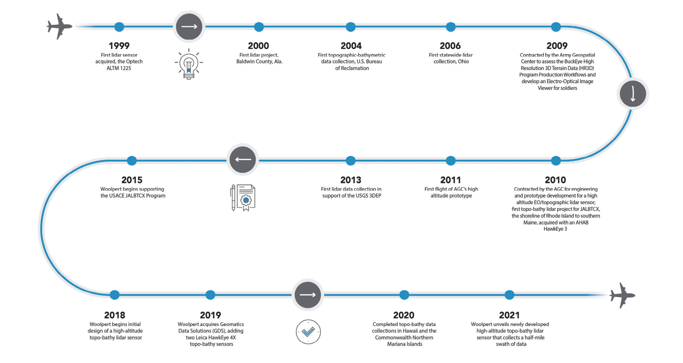
Notable moments in Woolpert’s lidar history. Graphic courtesy of Woolpert.
Woolpert was founded as an engineering and survey firm in 1911 and began providing geospatial services in 1969. In 1999, Woolpert acquired its first lidar sensor and used it to complete the first countywide topographic lidar data collection in Baldwin County, Alabama, in 2000. This set the stage for the firm’s innovative work with lidar. Woolpert conducted the world’s first riverine topobathymetric lidar collection in Washington state in 2004 and followed by developing and carrying out the first statewide lidar program of its kind in Ohio in 2006. In 2015, Woolpert was contracted to test new single-photon and Geiger-mode lidar technologies for USGS.
Also, from 2009–2013, Woolpert collaborated with the U.S. Army Geospatial Center (AGC) to support its evolving High-Resolution Three-Dimensional Terrain Data (HR3D) program. AGC’s BuckEye system, consisting of an airborne topographic lidar sensor and an electro-optical mapping camera, was created out of a warfighter necessity for high-resolution terrain data and imagery over urban and complex terrain in Iraq and Afghanistan. Woolpert provided early technical support to improve the system’s data processing and helped create an imagery viewer to enable soldiers to quickly access individual frames.
As the need for imagery and improved elevation data exponentially grew and extended beyond Iraq and Afghanistan, so did the need to collect the data more efficiently. This spurred the development of a system that could fly higher and collect data over a much larger area, while still maintaining the high resolution and accuracy of the current systems. This led to the development of the BuckEye 2 sensor.
Woolpert led the design, integration, and testing of BuckEye 2 and developed the initial data workflow and processing to satisfy the warfighter’s higher altitude and collection requirements. Woolpert and its mission partners successfully transitioned the sensor to AGC, immediately putting the system into operational use.
Since then, Woolpert has continually expanded its geospatial expertise and resources through innovation, leadership and strategy, acquiring five key geospatial firms in just over two years. The firm has flown more than three million square miles of lidar and imagery; has completed hundreds of topographic lidar missions for local, state and federal contracts; and continues to support multiple agencies and initiatives, including the USGS 3D Elevation Program. In addition, Woolpert has executed several topobathymetric lidar data collections in the last two years—including the coastlines of Alaska, Hawaii and the Commonwealth of the Northern Mariana Islands—to fulfill contracts with USACE, USGS and NOAA.
The firm owns and operates a fleet of aircraft, vehicles and sensors while partnering with industry giants like Esri, Google and Planet to provide novel, customer-focused solutions.
“Woolpert’s recent experience has allowed us to create innovative airborne lidar solutions when off-the-shelf products fall short of customer requirements,” Woolpert Senior Vice President Joseph Seppi said. “These investments are raising the bar and moving airborne lidar bathymetry forward as a growth area for Woolpert and the rest of our industry.”
Research and development
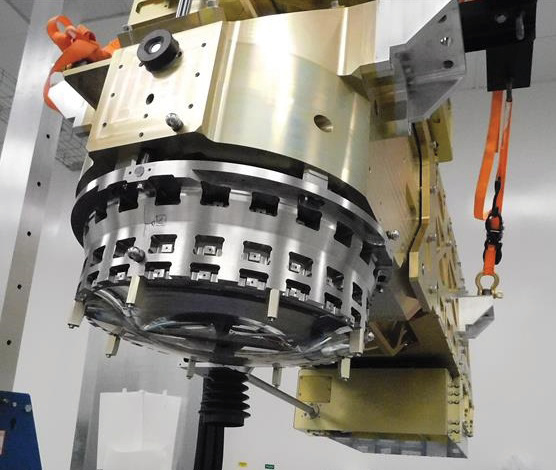
Woolpert’s engineering prototype sensor incorporates both civil and military requirements. Graphic courtesy of Woolpert.
So, how high can you fly and still collect lidar bathymetry? The response was to build a prototype system to collect at 10,000 feet that incorporated both tactical and civil operational requirements.
This new multispectral, multichannel lidar system emits green light to collect seafloor data and infrared light to collect topographic data, while simultaneously collecting high-resolution aerial images along a coastline. In addition, by collecting information on the Raman return, users can determine whether the data represents land or turbid water.
Most bathymetric lidar systems collect data at altitudes between 400 and 600 m, which is between 1300 and 2000 feet. Although collecting data from 10,000 feet is common for topographic systems, it is extremely challenging for bathymetric systems due to energy losses incurred when crossing the air/water interface and spreading light, which penetrates through the water column to reflect off the sea bottom. Woolpert wanted to collect bathymetric data at 10,000 feet to increase efficiency and flight safety for topobathymetric collections.
To accomplish this, the Woolpert team spent the last three years at its research lab developing BULLDOG, a multispectral, multichannel, topobathymetric lidar system that can fly higher and collect more data in less time than previous bathymetric systems. The patented lidar system maximizes the use of three different wavelengths of light—532, 647 and 1064 nm—by distributing them into five distinct detector channels designed for shallow water, deep water, Raman and infrared. The infrared light is further split into a linear mode and Geiger-mode channel utilized specifically for the sea surface and topographic measurements.

The Woolpert team spent the last three years at its research lab developing BULLDOG. This multispectral, multichannel, topobathymetric lidar system can fly higher and collect more data in less time than previous bathymetric systems. Graphic courtesy of Woolpert.
The team found that the biggest challenges were designing and engineering a flexible prototype that can collect lidar bathymetry from 10,000 feet while accurately collecting Raman. The Raman shift is the energy generated around 647 nm when the green light of the bathymetric laser interacts with water and shifts into a longer wavelength. The Raman signal can be used to accurately determine the water surface location when the water surface is very calm, mirror-like, or during night collections, and can aid in discrimination between land and water returns, which is critical to the accurate calculation of water depth.
However, Raman is an extremely weak signal. From 10,000 feet, simulations predicted single-digit photon returns, suggesting that the prototype had a 50/50 chance of Raman detection. Throughout simulations, modeling, design and testing, a focus was placed on noise reduction within the optical and electrical chain. Noise reduction coupled with a highly efficient telescope design contributed to successfully detecting Raman during engineering flights.
“With the Raman signal, we’re able to determine if things are wet,” Smits said. “Raman was included in sensor development in the 1980s and ’90s, but it was omitted from the current generation of sensors due to both size, weight and power (SWaP) constraints and implementations of additional sea-surface detection capabilities. We anticipate being able to detect and use the Raman signal to do things like land/water discrimination. If we’re flying at night and can’t take high-resolution images, the Raman signal can be a differentiator as to whether or not a particular laser shot is on land or water.”
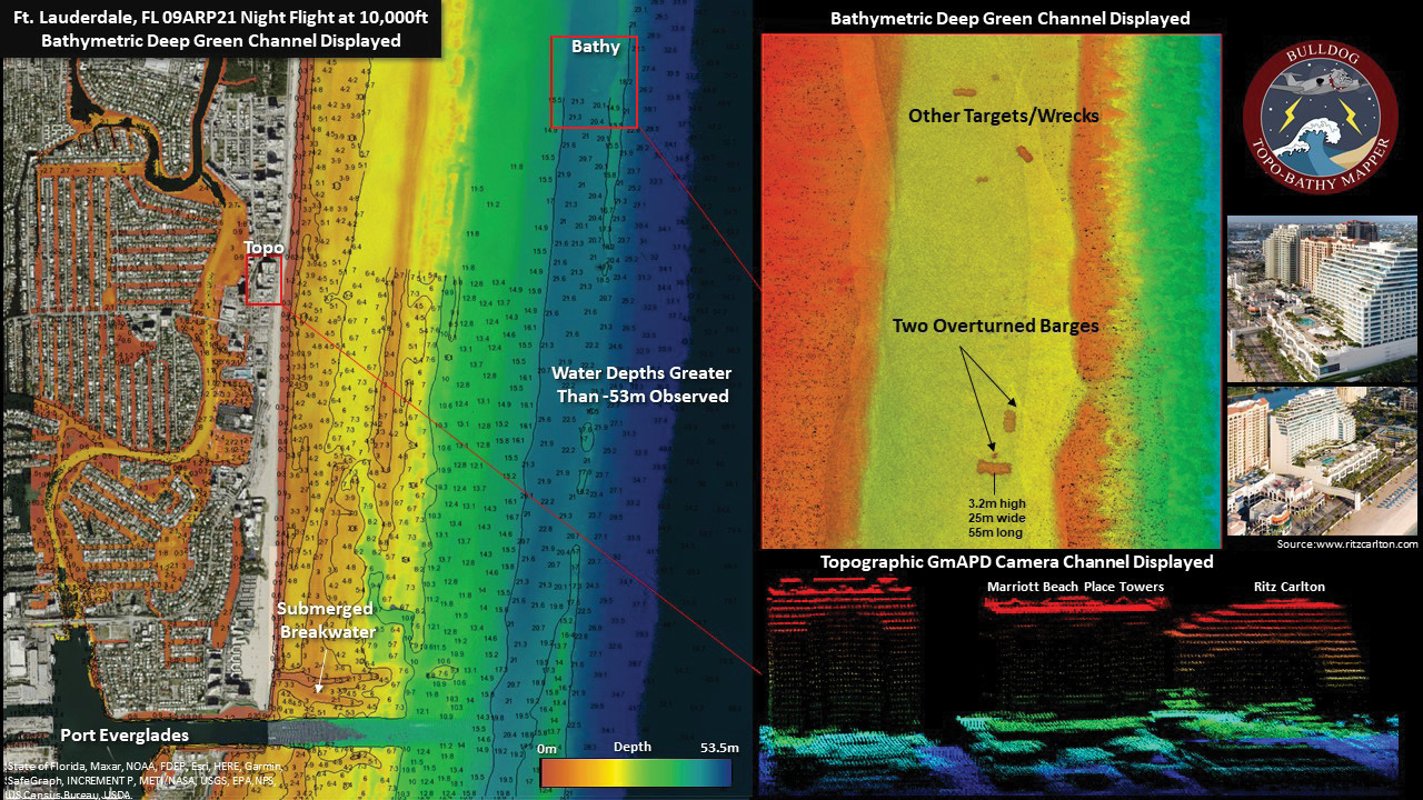
Topographic and bathymetric lidar data was collected on April 9, 2021, in Fort Lauderdale, Florida. The bathymetric data was overlaid with charted depths and contours for comparison. Image courtesy of USACE/JALBTCX.
BULLDOG can collect over a half-mile-wide swath of data at 10,000 feet in an aircraft traveling at 160 knots. At that altitude, flying in a straight line, BULLDOG can collect approximately 100 square kilometers of coastline every 40 minutes. In addition to manned aircraft, the initial design supports the ability to configure the system to support unmanned operations. It would require another spiral development to fully implement and test unmanned configurations.
This ability to fly higher and still collect high-resolution topobathymetric lidar data also requires a more powerful laser than is used in the topobathymetric lidar systems currently on the market. The research and development team, therefore, built the BULLDOG system around a custom 100-watt laser and custom thermal management unit. This laser requires more power and a more robust cooling system than other topobathymetric lidar sensors. Since lasers are inherently unstable, the research team was challenged to create a stable thermal environment for the system to work properly on an aircraft. If temperatures fluctuate outside set parameters and the laser’s energy fluctuates, the radiometric and system performance could be impacted.
Drawing on these lessons learned from decades of sensor ownership, operations and development experiences, the team created the BULLDOG system with the capability of real-time data processing, exploitation and dissemination (PED). This data-processing engine is designed to create 3D point clouds that can be colored by various attributes such as depth and Total Propagated Uncertainty (TPU). Testing is underway to allow the system’s integrated software to transmit data and information in near real time to systems on the ground, enabling analysts and decision-makers access to time-sensitive information.
Numerous applications for this technology have been developed with the needs of Woolpert clients in mind, and therefore range from priorities set forth by federal agencies such as USACE, U.S. Navy, NOAA and USGS, to state and local governments and agencies, military purposes, and everything in between. Continued research and development efforts will focus on both civil and commercial operational requirements, including reduced SWaP and multiple flying altitudes.
Moving forward
Accurate bathymetric data is expected to be an essential resource in safe navigation and decision-making for coastal mapping and charting, coastal resilience and management, and disaster response for years to come. The BULLDOG system was conceived to address this requirement by and for those who understand it. This approach will become increasingly prevalent moving forward.
“We have been excited to see early results from this new system and look forward to a full system characterization over the next year,” Wozencraft said. “Higher altitude not only increases data collection efficiency but also opens up areas in which we are able to survey, like high coastal terrain, and real-time data processing speeds up delivery of products to our customers.”
Woolpert Senior Vice President Jeff Lovin said working with lidar in the field for more than 20 years and using a wide array of sensors was crucial to the team’s ability to create this research and development lab and to build a sensor that fills this needed geospatial niche.
“Our focus on our clients’ requirements has enabled us to customize products and services to address those needs efficiently and effectively, effectively, reducing the time it takes to produce actionable information,” Lovin said. “This ability to engineer, build, deploy, collect, and deliver data and information is what sets Woolpert apart.”
Dr. Nathan Hopper is a project manager in Woolpert’s facility in Bay St. Louis, Mississippi, focused on the firm’s maritime market.
Michael A. Harper is a senior strategist supporting Woolpert’s rapidly expanding geospatial sector, working between the firm’s Bay St. Louis, Mississippi, and Arlington, Virginia, offices.