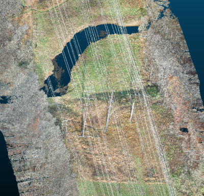
Huntsville, AL – Exelon Clearsight, industry-leading robotics inspection company, recently acquired GeoCue Group Inc.’s True View 615 3D Imaging System, adding to their fleet of cutting-edge drone mapping technologies. The True View 615 3D Imaging System collects high accuracy LIDAR and imagery concurrently in a single drone flight, increasing project productivity and efficiency. This mapping sensor is bundled with True View EVO, an extensive post-processing software and data management tool, forming a complete drone mapping solution. With this equipment, provides greater vegetation management insights with true colorized points clouds fused with 3D data. These outputs make it easier to visualize, inspect, and create derivative products such as vegetation encroachment data.
Exelon Clearsight is focused on leveraging innovation and technology to conduct sustainable and safe inspection for critical utility infrastructure to drive progress to a more sustainable future. They value the safety of their customers and strive to offer services that will improve efficiency and reliability, while reducing ownership costs. GeoCue’s True View sensor aids Exelon Clearsight in that mission by providing a unique set of LIDAR/imagery fusion data to deliver high-accuracy measurements and analytics. Examples of derived products from the True View 3DIS include colorized 3D point clouds, breakline enforced 3D models, profiles, cross sections, topographic contours, volumetric analysis, classified ground models and more. These products increase the value Exelon Clearsight provides their customers, and allows for even more detailed services, plans, and insights.
Alex Harvey, Solutions Delivery Architect at Exelon Clearsight comments, “I am very impressed with the True View ecosystem, from simplifying data collection operations in the field to post processing. I look forward to exploring new opportunities for Exelon Clearsight to provide value to our customers with the GeoCue’s True View platform.”
“We are extremely pleased to add Exelon Clearsight to our growing list of professional users of our True View ecosystem,” said Lewis Graham, President/CTO of GeoCue. “We are looking forward to refining our collection and processing tools to meet a new array of utility-based drone mapping applications that will be pioneered by Exelon.”
About GeoCue
GeoCue is the largest supplier of kinematic LIDAR processing tools in North America and LP360 is one of the world’s most widely used tool for exploiting point cloud data. In 2014, GeoCue Group started a division focused on using small Unmanned Aerial Systems for high accuracy mapping. Leveraging our expertise in production, risk reduction, and point cloud processing tools, we are continuing to bring new services and products to market to provide surveyors and other geomatics professionals exciting tools for geospatial data extraction using low-cost drones including Loki, our plug-and-play PPK direct positioning system, and now our new True View® drone camera systems product line. To learn more, visit www.geocue.com.
About Exelon Clearsight
Exelon Clearsight is a wholly owned subsidiary of Exelon – America’s leading competitive energy provider with six utilities serving over 10M electric and gas customers across more than 139k miles of lines. Our deep, end-to-end integration in the utility industry gives us a balanced perspective and unique insights, which we leverage to offer new ideas and create new value for our clients. Our fleet of innovative technology allows us to complete safe and effective inspections and provide actionable insights to not only improve system reliability and efficiency, but also identify points of improvement. To learn more, visit www.exelonclearsight.com
