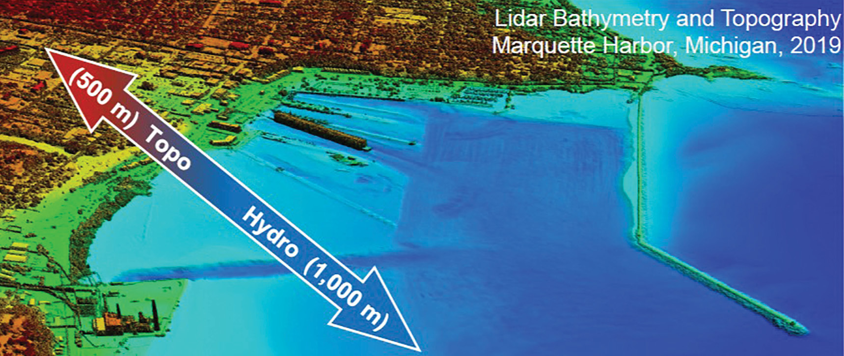
Figure 1: A topobathymetric lidar digital surface model depicting the 1500-m NCMP survey footprint. The data was acquired by USACE NCMP over Marquette Harbor, Michigan in 2019.
Record high water levels in the Great Lakes of the United States increase shoreline erosion, reduce efficacy of natural shoreline protection, and threaten valuable infrastructure related to industry, environment, and tourism. Temporally relevant, high-resolution mapping data is a critical requirement for informing decisions related to managing these threats. The US Army Corps of Engineers (USACE) uses mapping data to support its missions in navigation, flood risk management and ecosystem restoration. Requirements for regional coastal data are fulfilled by the Joint Airborne Lidar Bathymetry Technical Center of Expertise (JALBTCX). The USACE expert in coastal mapping, JALBTCX is a partnership among the Federal government, industry, and academia to perform operations, research, and development in airborne lidar bathymetry and complementary technologies. Federal partners include USACE and US Naval Oceanographic Office (NAVO), both of which acquire mapping data through operational coastal mapping and charting campaigns. Other Federal partners include the National Oceanic and Atmospheric Administration (NOAA) and the United States Geological Survey (USGS), which coordinate their mapping data acquisitions with JALBTCX through the Federal Interagency Working Group on Ocean and Coastal Mapping (IWG-OCM) with the aim of reducing duplicative mapping efforts, allocating resources for mapping in the most efficient manner, and ensuring wide dissemination and interoperability of mapping data. Together with partners from industry and academia, JALBTCX has fielded and operationalized three generations of airborne remote sensing platforms for the collection of mapping data in coastal environments. The 23-year partnership continues to coordinate on best practices for data acquisition and data product development, and leads research and development efforts to expand current technologies in support of emerging needs for mapping data that include, for example, needs for bathymetric data in inland and riverine environments.
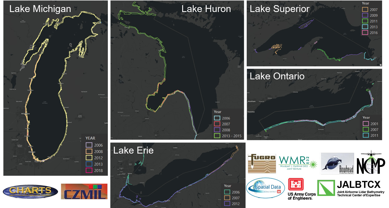
Figure 2: Geospatial extents of NCMP data coverage colored by year of acquisition from 2006 to 2013.
USACE coastal mapping is executed by JALBTCX under the USACE National Coastal Mapping Program (NCMP). The program’s goal is to acquire high-accuracy, high-resolution lidar elevation and imagery data on a recurring schedule along the sandy shorelines of the US. The survey footprint (Figure 1) extends from 500 m onshore of the shoreline to 1000 m offshore, or to laser extinction, whichever occurs first. JALBTCX aircraft fly at an operational altitude of 400 m above ground level, producing a swath of data approximately 300 m wide with each pass. Capture of the approximate 1-mile wide NCMP footprint typically requires 5-6 passes of the aircraft, depending on shoreline shape and airspace considerations. Survey coverage includes the important first line of infrastructure, the beach and dune system, and the nearshore out to the depth of closure. The footprint encompasses the “active” portion of the beach profile that plays a critical role in sediment mobility, transport, and deposition. Information gleaned from the mapping data supports the development of regional sediment budgets that USACE uses to understand and manage sediment at regional or watershed scales. The mapping data provides critical, temporally relevant baseline information to inform decisions related to the planning, operation, monitoring and maintenance of coastal flood damage risk reduction, coastal navigation, and ecosystem restoration projects within USACE.
NCMP in the Great Lakes
NCMP completed a third cycle of lidar and imagery mapping data acquisition in the Great Lakes in 2020. Acquisition of this data along the entire US shoreline of the Great Lakes typically takes 2-3 years due to challenging weather and water clarity conditions that limit acquisition windows to summer months. The first regional acquisition occurred during the summers of 2006, 2007 and 2008. Data acquisition was repeated in 2011, 2012 and 2013 to complete the second cycle of NCMP. The first and second NCMP cycles leveraged JALBTCX’s in-house survey capabilities, as well as those provided under contract to USACE Mobile District. The most recent, third cycle of data acquisition that was completed in 2020 began in 2018. Figure 2 depicts the geospatial extents of NCMP data coverage acquired each year for surveys from 2006-2013.
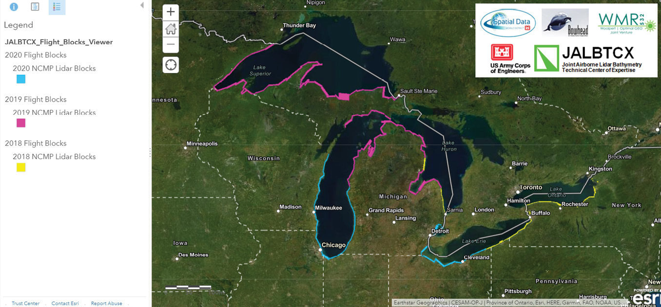
Figure 3: Web map depicting the geospatial extents associated with the 3rd cycle of NCMP data acquisition in the Great Lakes from 2018 to 2020. The extents are colored by acquisition year.
The recent, third cycle of NCMP data (Figure 3) was acquired with JALBTCX’s Coastal Zone Mapping and Imaging Lidar (CZMIL). This third-generation platform for integrated coastal mapping and environmental monitoring includes a 532-nm (green) wavelength lidar with simultaneous topographic and bathymetric capabilities, a 150-megapixel 3-band digital camera that collects images at 5-centimeter on-ground resolution and a hyperspectral imager that collects 48 spectral bands between 380 and 1050 nm at 1 m on-ground resolution (Wozencraft et al., 2019). Topographic lidar meets the USGS Lidar Base Specification for Quality-Level 2 (QL2) lidar, or two measurements every square meter on ground at 10 cm root mean square error vertical accuracy. Bathymetry is acquired with a vertical precision of 15 cm (one standard deviation) to depths of up to approximately 60 m. NCMP operates CZMIL in a contractor-owned and operated aircraft, including Cessna 406s, Beechcraft KingAirs, and Basler BT-67s, to meet mission objectives. Regardless of airframe, the swath width, which is approximately three quarters of the operating altitude, is constant over the entire operational depth range of CZMIL.
See PDF for complete graphics
Opportunities for expanding NCMP data coverage
The NCMP planning process includes key personnel from JALBTCX, USACE Districts and partners in the Federal mapping community through the IWG-OCM. Planning meetings are opportunities to discuss additional requirements for mapping data located in areas near the NCMP footprint. Oftentimes, NCMP mission plans can be extended, or added to, at minimal cost to the District or partner to expand data acquisition. Several example projects in the Great Lakes have been accomplished by coordination with local USACE Districts and partners in the Federal Mapping Community. Specific examples include:
- 2021 NOAA Whitefish Bay hydrographic survey requirements met for select areas by the 2019 NCMP Lake Superior dataset
- 2019 NOAA northern Lake Michigan hydrographic survey requirements met by the 2019 NCMP Lake Michigan dataset
- 2018 USACE Buffalo District and the USACE Engineer Research and Development Center (ERDC) partnered with JALBTCX to expand NCMP coverage into wetlands of interest along Lake Ontario
- 2012/2013 USACE Detroit District leveraged Federal Emergency Management Agency (FEMA) funds to partner with JALBTCX to extend NCMP coverage into Green Bay, and extend coverage for inhabited areas to update wave modeling in the Great Lakes
- 2006/2007 National Park Service partnered with JALBTCX to add coverage of Isle Royale, Minnesota and the Apostle Islands, Wisconsin
NCMP data products
Data processing for NCMP lidar and imagery data is accomplished with software from the sensor manufacturers in combination with commercial off-the-shelf software packages. All lidar, true-color imagery and hyperspectral imagery is downloaded from solid-state data collection drives to processing computers, where it is processed from native sensor formats, geo-corrected through the application of GNSS and aircraft attitude data, and developed into industry-standard data formats. For example, the CZMIL lidar data is converted from the raw CZMIL waveform to a CZMIL point cloud in the industry-standard LAS format. QA/QC of the lidar point cloud is performed in a 3D point-cloud editing environment. This ensures that the point cloud meets current system specifications and is free of any system biases or navigation errors. Post-processing of the lidar point cloud then continues with the application of an industry-standard ground classification algorithm through which each point is classified as ground (i.e. roads, parking lots, bare and grass-covered ground) or non-ground (i.e. vegetation, trees, buildings). Following QA/QC of the point cloud classification, raster elevation products are generated at 1-m resolution. The digital surface model (DSM) products include points from each classification (non-ground, ground, and bathymetry), whereas the digital elevation model (DEM) products include ground and bathymetry only. A vector product, defined by USACE as the Great Lakes Low Water Datum (GLLWD) elevation contour, is derived from the DEM products, and is manually edited to remove back-bay/back-barrier contour segments and any “islands” landward of the primary alongshore contour. The goal of editing is to produce a single, continuous contour that approximates the shoreline position.
All NCMP data products are provided in geographic coordinates, in decimal degrees of latitude and longitude, that are referenced to the North American Datum of 1983 National Adjustment of 2011 (NAD83 NA11). Elevations are referenced to the International Great Lakes Datum of 1985 (IGLD85) and are provided in meters. The basic tier of data products includes the classified (non-ground, ground, bathymetry) point clouds, DSMs, DEMs, GLLWD contour and true-color imagery mosaics. Example products developed from USACE’s 2018 NCMP Lake Ontario project are depicted in Figures 4-9.
NCMP data discovery and access
USACE NCMP data is available for free public use from the NOAA Digital Coast’s Data Access Viewer (coast.noaa.gov/dataviewer/#/). The site provides capabilities for dataset search by user-defined areas of interest. Once the dataset list is populated from the search, a user is led through a custom data request submission capability that facilitates data format conversions, custom filtering, and coordinate system and datum transformations. Data is then made available as a direct download in a format that is available for use without requiring any additional data processing or manipulation. Direct download URLs to USACE NCMP datasets acquired in the Great Lakes are listed in Table 1.
Readers should consult JALBTCX’s Production Status Web Map (arcgis.com/home/item.html?id=1d698d610bec432e8374b46ea22db7ac) for the status of the third cycle of NCMP mapping data in the Great Lakes (Figure 10).
NCMP data products support regional monitoring efforts
The Great Lakes Restoration Initiative (GLRI) is a multi-year collaborate effort among NOAA, USGS and USACE to inform decisions aimed at mitigating hazards to Great Lakes ecosystems and protecting and restoring the largest freshwater system in the world (Great Lakes Regional Collaboration, 2005). ERDC is working with the multi-agency team to characterize nearshore geomorphology (i.e. bluffs, sandbars, beach slope, beach width, etc.) in the Great Lakes to support the development of sediment budgets and a coastal resiliency index for each lake. This effort leverages the NCMP DEM products in conjunction with DEMs produced by other entities. Data products for each lake are being integrated into near-seamless DEMs that serve as input to a novel geomorphic feature extraction workflow to detect/delineate nearshore geomorphology characteristics that include bluffs/dunes (bluff/dune crest and toe), sandbars (number of bars, water depth over bars, and distance offshore), beach slope, beach width, and nearshore shape/curvature (Figure 11).
These outputs provide the basis for the development of sediment budgets and geomorphic vulnerability indexes in the Great Lakes. Together, both efforts will improve the understanding of key influences on spatially varying rates and impacts of shoreline erosion for each lake. This understanding is key to informing mitigation and restoration efforts related to shoreline erosion and ecosystem degradation in the Great Lakes.
Future NCMP mapping in the Great Lakes
The USACE NCMP operates counter-clockwise around the US on an approximate 5-year update cycle. Future regional-scale NCMP mapping efforts in the Great Lakes will tentatively begin in the 2023/2024 timeframe, contingent upon program schedule elsewhere and agency funding. Stakeholders in the Great Lakes are encouraged to contact JALBTCX, jalbtcx@usace.army.mil, to discuss requirements and opportunities for mapping data during the next NCMP acquisition cycle. 
References
Great Lakes Regional Collaboration, 2005. Great Lakes Regional Collaboration Strategy: To Restore and Protect the Great Lakes, 70 pp. gsgp.org/media/1847/glrc_strategy.pdf.
Wozencraft, J., L. Dunkin, E. Eisemann and M. Reif, 2019. Chapter 7: Applications, Ancillary Systems, and Fusion, Chapter 7 in Airborne Laser Hydrography II (ed. W. Philpot), Cornell eCommons. 279 pp: 207-230. doi.org/10.7298/tbxj-3067.
Charlene Sylvester is a research physical scientist with ERDC’s Coastal Hydraulics Laboratory. Charlene supported NCMP with Mobile District and JALBTCX for 11 years, deploying with the field teams for NCMP and Emergency Response survey operations. Charlene recently transitioned to a role at ERDC, where her knowledge in geospatial data analysis, lidar processing and quality control, coastal processes, geospatial metadata and web GIS is applied across a number of R&D efforts that utilize JALBTCX data.