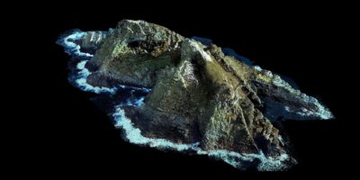
Fugro lidar point cloud Geo-data of Ireland’s UNESCO World Heritage Site Skellig Michael (Scellig Mhichil in Irish)
Leidschendam, Netherlands, 29 September 2021 – Fugro has won a contract to capture high-resolution lidar Geo-data along Ireland’s southern and western coastline and create a detailed 3D elevation model. The project has been commissioned by the Office of Public Works (OPW), the lead agency for flood risk management in Ireland, to deliver a consistent, uniform and up-to-date baseline elevation model of this part of the Irish coast.
Climate change has resulted in rising sea levels and extreme storm events, which impact both built and natural coastal assets, and Fugro is well placed to support climate change adaptation projects for a safe and liveable world. The OPW has commissioned Fugro to deliver a baseline survey of 1798 km² of Ireland’s south and west coasts to identify areas at current or future risk of coastal change and flooding. Existing and future surveys can also be compared against this important baseline survey to facilitate enhanced risk assessment of coastal change at multiple scales from national to regional level.
While the Geo-data is primarily being captured to support OPW’s role in flood risk management, it is anticipated to also be a valuable resource for stakeholders including local authorities, consultants, researchers, third-level institutions, and those with responsibilities for the management of coastal environmental or heritage sites. The baseline survey includes the UNESCO World Heritage Site at Scellig Mhichil, which is managed by OPW Heritage Services.
To ensure maximum coverage of the target area, Fugro is currently acquiring the lidar Geo-data using a specialist survey aircraft and high-resolution lidar sensor during low tide conditions. The use of airborne lidar technology offers many advantages over traditional survey techniques, including the capture of increased volumes of Geo-data during faster cycle times, reduced safety and technical risks, and the potential for simultaneous multisensor Geo-data acquisition.
Huug Haasnoot, Fugro’s Director for Land Asset Integrity in Europe and Africa, said: “Airborne lidar is ideal for achieving detailed mapping along complex coastlines and the nearshore. The Geo-data acquired by Fugro will form part of OPW’s strategy for seamless elevation mapping coverage extending landward and seaward of the coastline to help determine where future interventions are needed to best manage coastal change and the risks from more frequent extreme coastal storm events.”
About Fugro
Fugro is the world’s leading Geo-data specialist, collecting and analysing comprehensive information about the Earth and the structures built upon it. Adopting an integrated approach that incorporates acquisition and analysis of Geo-data and related advice, Fugro provides solutions. With expertise in site characterisation and asset integrity, clients are supported in the safe, sustainable and efficient design, construction and operation of their assets throughout the full life cycle. Employing approximately 9000 talented people in 61 countries, Fugro serves clients around the globe, predominantly in the energy and infrastructure industries, both offshore and onshore. In 2020, revenue amounted to EUR 1.4 billion. Fugro is listed on Euronext Amsterdam.
