Thompson Engineering used the mdLiDAR1000HR and mdMapper1000DG to survey the USS Alabama Battleship Memorial Park and create a digital twin.
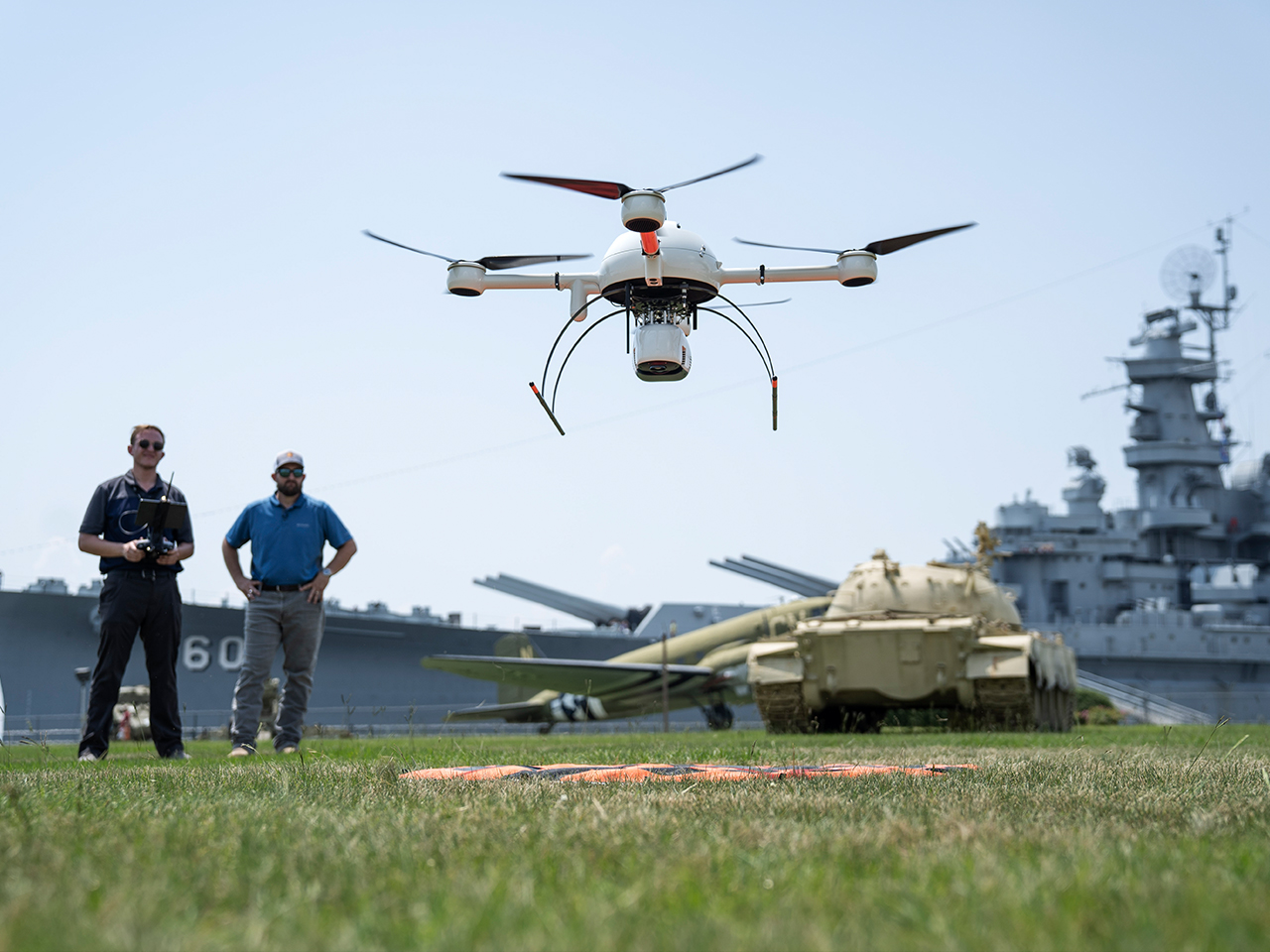
Ross Kenney, NEI UAS Sales and Support Lead, pilots the mdLiDAR1000HR while Adam McCullough, Survey Technology Lead at Thompson Engineering observes at the USS Alabama Battleship Memorial Park.
Rome, NY – In these 4 exciting new episodes of Down to Earth, Thompson Engineering, a proven leader in planning design, construction, and response solutions, utilizes drone Photogrammetry and LiDAR technology to survey, map, and create a digital twin of the USS Alabama Battleship Memorial Park to help with preservation and maintenance efforts.
To see how they collected and processed the data to create both a digital twin and complete orthophoto of the park, CLICK HERE to watch NOW On-Demand.
“Down to Earth” is a reality series that shows how real surveyors collect data and turn it into real deliverables, despite challenging terrain, rough weather, and hidden dangers. In this latest series, the crew journeys into Mobile, Alabama, where the USS Alabama Battleship is the anchor attraction at the Memorial Park which has welcomed generations of family members, veterans, and tourists. However, large structures, an active tourist site, and other challenges face the team at Thompson Engineering as they set out to survey the Mighty A.
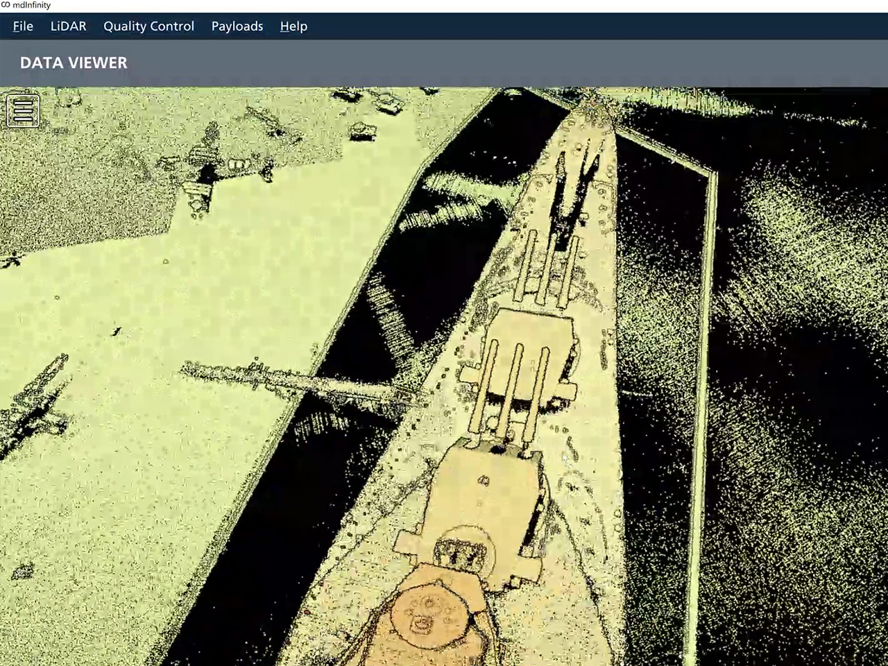
A partial view of the point cloud that creates the digital twin of the USS Alabama.
On these episodes of Down to Earth, Robert Chrismon, PLS and Marketing Manager at Microdrones, joins the Thompson Engineering team to observe these challenges, provide drone surveying expertise, and offer data processing support. Brad Busby, the Survey Team Lead at Thompson says, “Having Robert out there is great support since he’s a licensed surveyor. He can relate to us and understand what we’re talking about.”
In episode 1, Robert and the team from Thompson Engineering meet up with Ross Kenney, the UAS Sales and Support Lead from Navigation Electronics, Inc. (NEI), a distributor of Microdrones integrated systems, who’s excited to demonstrate the capabilities of the all new mdLiDAR1000HR. According to Kenney, “We’re going to be able to scan every nook and cranny of that ship.” That’s because the new mdLiDAR1000HR creates high resolution point clouds and provides increased coverage.

Cody Floyd, Surveyor PIC at Thompson Engineering, pilots the mdMapper1000DG to collect photogrammetric data.
Episode 2 introduces Cody Floyd, Surveyor PIC at Thompson, who pilots the mdMapper1000DG to perform the photogrammetry mission. This will collect the data to create an orthophoto of the entire site and provide colorization for the LiDAR point cloud. Floyd, who also interned at the Park, explains the deliverables. “We’re here to do a survey of the Battleship Memorial Park to provide them with something they can use for future improvements and additions.”
The third episode occurs at the Mobile office of Thompson Engineering where the team works through the process and visualize portion of the workflow. Jason Gibson, PLS for Thompson Engineering reviews the trajectory processing while working towards a final orthomosaic and then Robert Chrismon displays the digital twin of the USS Alabama in a LiDAR point cloud created in mdInfinity. Adam Mccullough, Survey Technology Lead at Thompson was excited to see the data. “To me the data speaks for itself. Just looking at the point cloud, you can see how dense and crisp it is around the buildings, the planes and all the cars in the parking lot.”
The final episode is a new segment featuring a round table discussion where the team reviews the project, shares their final thoughts and insights all while enjoying a cold beverage. Watch the entire series now and see how to create a digital twin with drone LiDAR.
About Thompson Engineering
Thompson Engineering was formed in 1953 to provide quality assurance for construction projects related to industrial, infrastructure, and community development. As a drilling, materials testing, and construction inspection and chemistry laboratory firm, we supported the engineering and construction industry. Our early years were building blocks that allowed us to get our feet wet–literally –performing services along the Gulf Coast’s rivers, bayous, and streams. Today, Thompson Engineering is known for leadership on projects defining skylines, coastlines, and transportation lines. We support clients in the industrial, commercial, transportation, federal, and municipal markets. We are often the first company on project sites conducting environmental assessments, land surveys, and geotechnical studies. And our project management and construction management services often mean we are the last ones to leave. We are a proven leader in the planning, design, and construction of major transportation, economic development, and waterfront projects across the Southeast.
About Microdrones
Microdrones grew out of the collaboration between the German inventor of the world’s first commercial quadcopter and a determined surveying payload and software developer in North America. The result is a global aerial mapping technology company that delivers complete and reliable mapping systems specifically developed for the surveying, mining, construction, oil & gas and precision agriculture industries. Microdrones Integrated Systems are industrial tools addressing specific complex mapping challenges for professional customers, relying on a fully integrated geospatial workflow that enables cutting-edge software technology from Microdrones to transform raw data collected in the field by Microdrones survey equipment into valuable high-quality survey-grade data. Microdrones is widely recognized for its LiDAR technology leadership. Microdrones has engineering centers and manufacturing facilities in Germany, Canada, France, China and the United States, as well as a sales, support and distribution network spanning six continents. Microdrones serves markets around the globe. To learn more about Microdrones, visit www.microdrones.com or follow @Microdrones on Facebook, LinkedIn, or Twitter.
