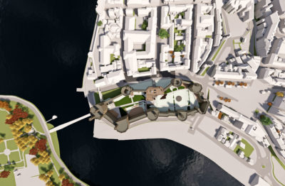
“We use Bluesky models to accurately assess the impact our proposals have on key views,” commented Paul Thornborough, BIM Manager at Buttress. “This may be the effect a proposal has on the view of an historic building from across a valley or how a project relates to its immediate neighbours. The idea of using geographically accurate data is that anyone viewing our projects can immediately realise the true scale of the proposal and appreciate it within its real-world context.”
Photogrammetrically derived from stereoscopic aerial photography, the models are fully rendered and are provided as either wireframe or block models in a format suitable for use in both CAD and GIS software. The Bluesky data is supplied complete with a Digital Terrain Model (DTM) and can be created to different levels of detail (LOD). Additional features, such as transport infrastructure or environmental features can also be added.
“I have always been impressed with the professionalism we receive from Bluesky; from the initial quote all the way through to receiving data as ordered,” concluded Thornborough. “All special requests are accommodated, especially where additional detail is required within the context model.”
Buttress is leading design studio based in Manchester. Providing architecture, urban design, interiors and conservation design services Buttress believes that architecture is as much about people and buildings, and that buildings should be shaped by their surroundings, their role and the people that will use them.
About Bluesky
Bluesky International is the leading aerial survey and geographic data company in the UK producing and maintaining seamless digital aerial photography and height data on a national scale in both Great Britain and the Republic of Ireland. Bluesky also undertakes bespoke surveys, including LiDAR, for a range of public and private sector clients. Bluesky International operates a range of aircraft and sensors including three Ultracam Eagle Mark 3s, two CityMappers which allow the simultaneous collection of vertical and oblique imagery as well as LiDAR data, and a Galaxy LiDAR which is mounted with a thermal sensor and survey grade camera. These systems put Bluesky International in the enviable position of being able to provide customers with unique and cost-effective geospatial solutions. As well as being an established and respected aerial survey company Bluesky International is also highly innovative and continually strives to develop new products and services by embracing new technology and methods. This has resulted in the development of some unique products such as the National Tree Map (NTM). These datasets underpin long term contracts with local and central governments and many major blue-chip companies from a range of market sectors including financial services, utilities, telecoms, web portals, construction and environment. Bluesky International has offices in the UK, US, Republic of Ireland and a dedicated production centre in India. https://www.bluesky-world.com/