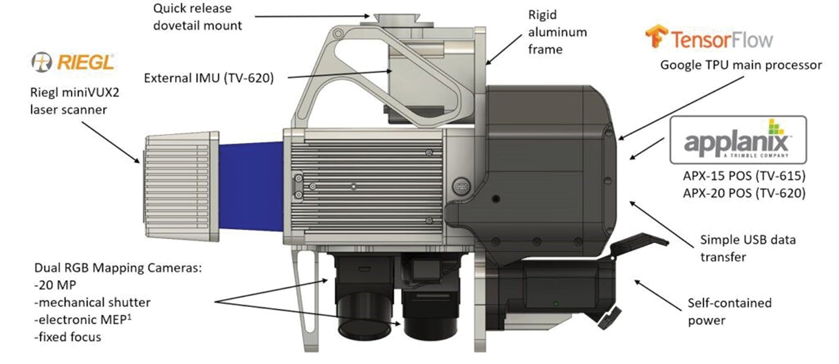
TrueView 615 3D Imaging System
As a provider in lidar and drone mapping solutions we constantly monitor the lidar scanner market, searching for the perfect laser sensors to integrate into our True View product line. A True View 3D Imaging Sensor (3DIS®) contains a number of integrated components such as the laser scanner, cameras, time synchronization systems and so forth. In this article, I am referring only to the laser scanning component. For example, in Figure 1 the laser scanner is the RIEGL miniVUX-2UAV. How do we select the right scanner for the data products we are trying to extract?
Survey-grade laser scanners
At the survey-grade end of the business (such as GeoCue’s True View 615), this is easy. These scanners were purpose built for collecting high-accuracy topographic data with high sensitively and network accuracy. The only manufacturers of survey-grade laser scanners for drones are Teledyne Optech and RIEGL. GeoCue currently offers RIEGL-based products and is constantly monitoring new solutions from Teledyne Optech.
Utility-grade laser scanners
On the “utility-grade” side of things, the performance of a particular lidar scanner cannot solely be predicted from its manufacture-supplied specification sheet.
Outside of the RIEGL and Teledyne Optech purpose-built scanners, all other drone laser scanners are repurposed automotive or industrial scanners.
Laser-scanner pulse repetition rate
In this article, we will examine the pulse repetition rate (PRR) of the scanner. PRR is the number of pulses emitted by the scanner per second.
Example: the PRR of the Quanergy M8 Ultra (the scanner used in the True View 410) is 430,000 outbound pulses per second (so 430 kHz).
However, the M8 belongs to the 360° class of rotating scanner (as do most of the RIEGL systems). We use 90° to 120° of this in our field of view (FOV), since the remainder of the rotation is scanning the bottom of the drone! Let’s be conservative and say we limit our swath cross-track to ±45°. This means we use 90° of the total FOV which embraces one quarter of the available pulses. Thus, we have an effective PRR of 107,500 pulses per second.
Now, consider the RIEGL miniVUX-2UAV used on GeoCue’s True View 615/620 3DIS. This scanner is also a 360° configuration with a PRR of 200,000 pulses per second. If we again consider our ±45° cross-track FOV, we see we have an effective PRR of 50,000 pulses per second, less than half that of the True View 410!
So how can it be that the miniVUX-2UAV is a more capable scanner? The key is the number of returns seen by the scanner, not the number of outbound pulses.
Many factors in addition to the number of outbound pulses contribute to the number of returns, for example:
- the energy in the outbound pulse
- the divergence of the beam
- the size and quality of collector optics
- the reflectivity of the object that is reflecting the pulse
- the sensitivity of the detector
No sensor manufacturer (of which I am aware) even attempts to quantify the number of expected return pulses. The closest we can come is the range of the sensor, expressed as a function of the reflectivity of the surface. But we find this to be dubious in all the automotive-grade laser scanners.
What are you to do when evaluating the system you need?
I think the best approach is to request data from the sensor flown over the type terrain that will be your “sweet spot” for business.
Example: If coal inventory is something that you must be able to do with your scanner, then ask for data from coal stockpiles. If you are trying to decide between several scanners, try to have them flown under the same operating parameters (altitude, drone velocity, etc.).
At GeoCue we are very careful about the information that we supply. We will provide you with information that is accurate to the best of our understanding. If our understanding is not sufficient to accurately answer your questions, we will tell you that! If you have specific questions that are not being addressed, please feel free to email us.