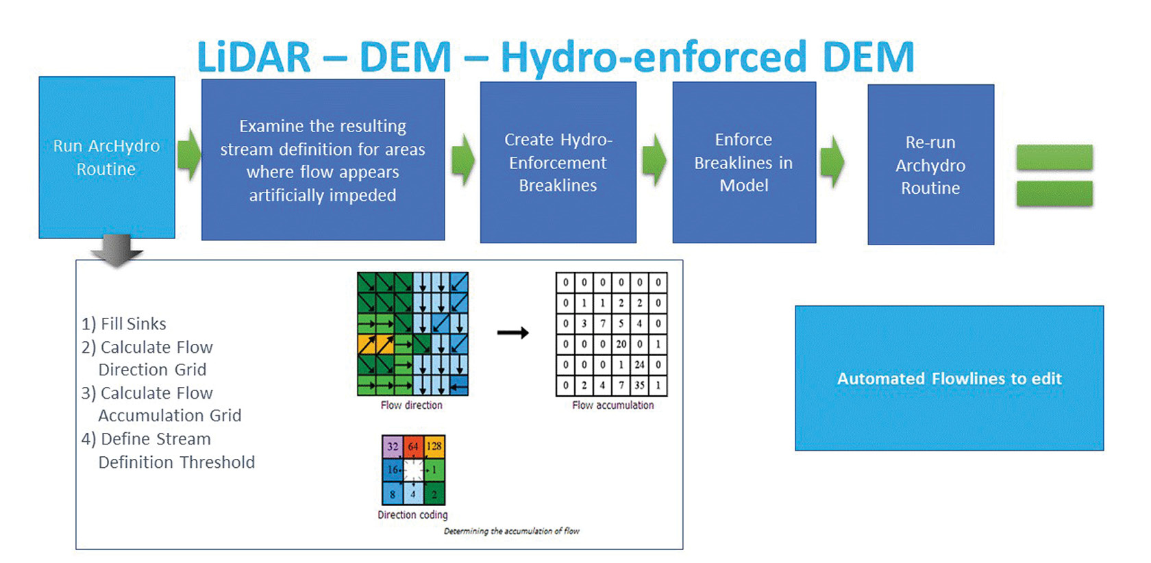
Figure 1: Basic workflow to map flow accumulation across landscape.
The exponential growth of lidar coverage across the nation has sparked considerable discussion on how to leverage this data to create Elevation-Derived Hydrography (EDH). Moving from a lidar bare-earth DEM to high quality, usable hydrologic line and polygon vectors, however, is more difficult than GIS manuals suggest. Running an algorithm is easy. More difficult is producing a data set that meets the requirements and standards of hydrologists and the data programs that support their work, the two most notable being the National Hydrography Dataset (NHD) and the Watershed Boundary Dataset (WBD). The key is to produce data sets that are both consistent and accurate enough to provide the information that users need to make decisions. Each region of the US has its own unique challenges due to its particular topography, land use, and geology. This article focuses on some of the challenges of developing EDH in Florida, which is generally flat and has widespread karst geology.
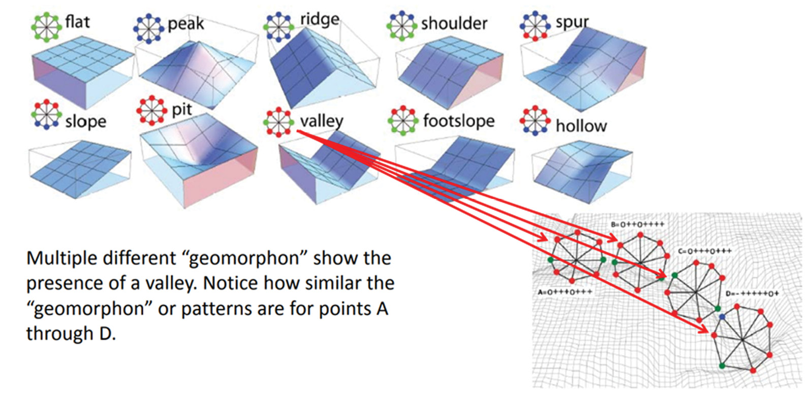
Figure 2: Characterization of landscape features using geomorphons.
To understand the challenges, we first need to understand the process for creating EDH. There are two main approaches to developing hydrography. The first involves mapping the slope and aspect of the landscape to obtain flow direction and then simulating the accumulation of flow across that landscape. A stream is then formed when a certain flow accumulation threshold is reached. This process is shown in Figure 1. The second approach is to analyze the shapes and formations within a landscape and how they relate to one another to classify features into what are called geomorphons. When this analysis is conducted at multiple scales it can be used to characterize large valleys and small stream channels (Figure 2). Both these approaches have their advantages and disadvantages and so are often best used in conjunction.
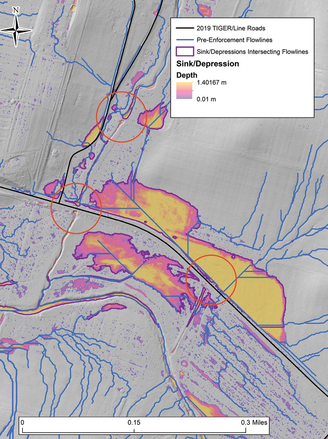
Figure 3: Ancillary information helps focus the attention of data reviewers where automated hydro-enforcement fails.
Regardless of the extraction technique or combination of techniques, a critical first step in any hydrology extraction from a lidar DEM is hydro-enforcement. For this process, the bare-earth lidar DEM is modified so that the tops of selected drainage structures (bridges and culverts) are removed to depict the terrain under those structures. Hydro-enforcement enables hydrologic and hydraulic models to depict water flowing under and through these structures, rather than appearing in the computer model to be dammed by them. Although hydro-enforcement can be largely automated, it does require manual quality control to ensure that the automated processes produce accurate representations of the reality on the ground. This manual review can be time-consuming, so an efficient workflow is required. Focusing on where errors are most likely to occur and directing editor reviews to those locations has proved to optimize results. NV5 Geospatial (formerly known as Quantum Spatial) achieves this by overlaying ancillary data such as depression depth and road networks on the derived stream network. In Figure 3 the areas that require enforcing are shown in red circles. Ancillary data allows the reviewers to focus their efforts at these points in the map.
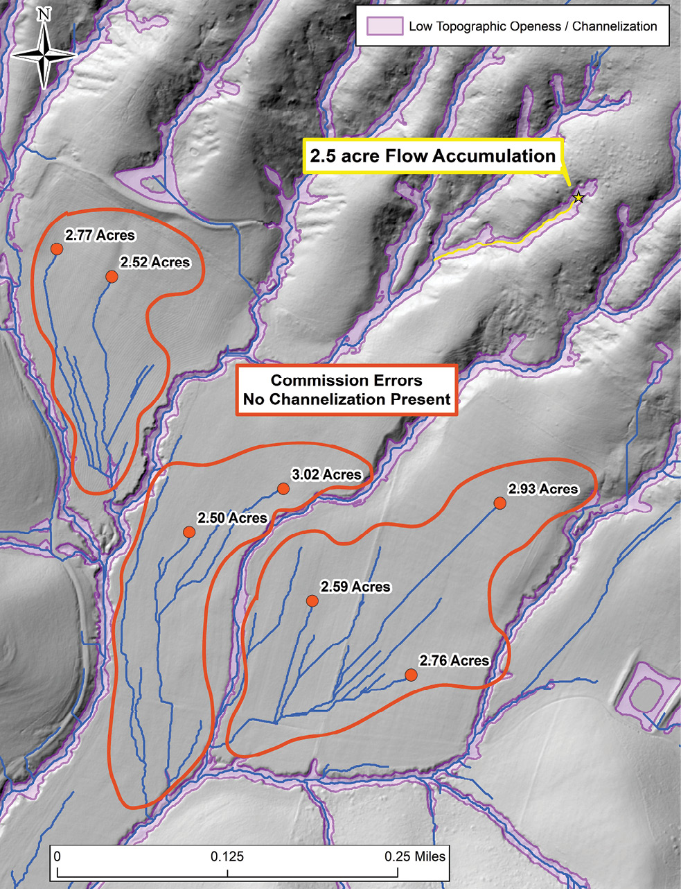
Figure 4: Streamlines intersected with a topographic openness layer to show where they should be retained and dropped.
Once the DEMs have been hydro-enforced, processing can move on to stream extraction. Traditional stream delineation is predicated on the principle that stream flow occurs when a minimum threshold of contributing surface area is exceeded. Although this is true, this threshold will vary depending on climate and landscape conditions. Streamlines are required to meet both a minimum length criterion and fall within a channel. Depending on the environment, very different stream definition thresholds may be needed to meet these requirements. Inspection to make sure that all streamlines clearly follow visible channelization in the ground model is critical to creating an accurate and therefore useful data product. This is a particular problem in Florida, where the area is flat and there are large areas of agriculture. We have found that topographic openness is a good indicator of true stream channelization in the bare earth. This can be superimposed on the streamlines to quickly distinguish commission errors and identify which streamlines should be retained (Figure 4).
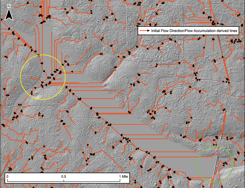
Figure 5: Streamlines created using the flow accumulation approach (above)—note the errors in flow across areas circled in yellow; streamlines created using the flow accumulation approach thinned for EDH rules using an iterative sink removal approach (below).
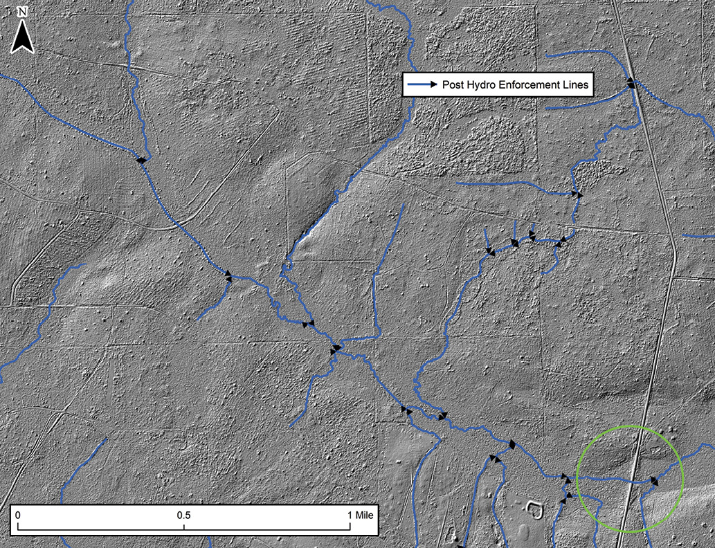
Another problem with stream extraction in Florida is that there are many large sinks or true depressions in the landscape (think swamps and gators!). Flow direction and geomorphons do not perform as well in areas of low slope and so great care is needed to prevent hydrologically linking areas where there are no true above-ground connections. The karst landscape of the state often means there are underground connections, but this is not something that can be interpreted from lidar. In Figures 5 and 6 we show how the flow lines would be derived if we relied purely on flow directions and flow accumulation rules. In Figure 5, NV5 Geospatial avoided this problem by eliminating these sinks incrementally, thus preserving the slightly higher area circled in yellow that maintains the separation of the two hydrologic systems. In Figure 6, the main stem of the river flowing through low relief swampy areas is not identifiable through the flow accumulation approach. It can, however, be discerned using the lidar intensity image based on the low reflectivity of the infrared lidar over this area and the total absence of returns from the middle of the channel.
 Each region in the US will have its own characteristics when it comes to developing EDH. Although automated tools are essential to ensuring a cost-effective creation of these data sets, NV5 Geospatial has found that creating consistent and high-quality hydrology is not easy—and has developed processes to meet the challenge.
Andrew Brenner directs water programs for NV5 Geospatial. He has worked on geospatial data analysis for over twenty years. His focus in on the application of geospatial technology to resolve real world challenges. Andrew has developed hydrographic data using imagery and lidar, led watershed management projects and run hydrologic modeling initiatives. He has a Ph.D. in environmental physics and an undergraduate degree in agriculture.
Cathy Power lives in Corvallis, Oregon and serves as a technical expert for NV5 Geospatial. Cathy has been working with lidar and lidar derivatives for over a decade. Her principal focus in recent years has been the derivation of high-resolution hydrologic networks in support of national and local hydrology programs.
Mischa Hey lives in Corvallis, Oregon and serves as NV5 Geospatial’s senior technical domain expert with over 15 years of direct experience developing applied GIS solutions. Mischa works primarily in development and deployment of biophysical modeling analytics derived from remote sensing data.