
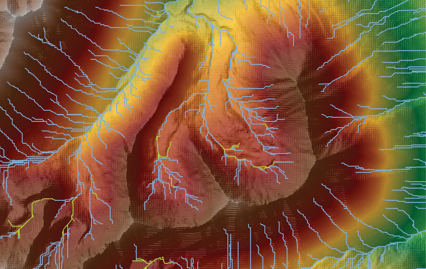
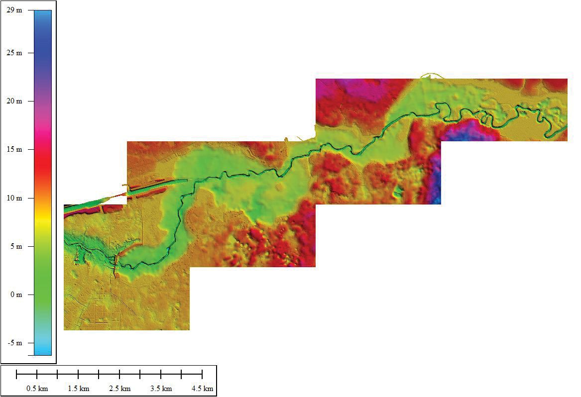
Figure 1: Small area of Upper Kobuk River, Alaska watershed with elevation-derived hydrography (blue lines) for updating the National Hydrography Dataset (NHD).
Dewberry’s Geospatial Technology and Services has been a gold sponsor of the FL-ASPRS/UF Lidar Workshops since the first one in 2016. The sponsorship and participatory support from Dewberry has been well received by the FL-ASPRS Region and workshop attendees. Multiple Dewberry staff have presented remote sensing projects contracted through several of the water management districts, the National Park Service, and the US Geological Survey (USGS), giving updates about ongoing lidar and related projects, as well as providing insights on other aspects of remote sensing and lidar activities. Dewberry is a major geospatial firm in Florida and maintains a large presence with 18 offices and over 350 staff in the state.
As a corporate ASPRS sponsor, Dewberry partnered with ASPRS to edit and publish The DEM Users Manual, which is now in its 3rd edition1. Amar Nayegandhi and David Maune, the primary authors and editors, were assisted with contributions from several Dewberry industry experts. The 3rd edition has already sold 500 copies. The editors have held book-signings for the Florida ASPRS Region at previous workshops.
For the Fall 2020 “virtual” Lidar Workshop, Amar Nayegandhi presented several recent topographic lidar projects. These emphasized successes that Dewberry has achieved through partnerships at the national, state and local levels.
Topographic lidar at the national level
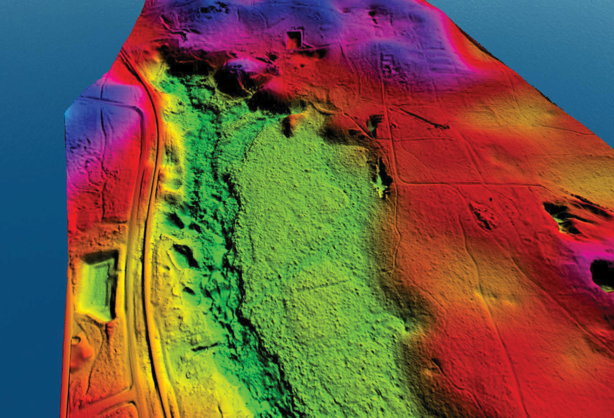
Figure 7: Lidar study of Rainbow Springs Aquatic Preserve, Marion County. Map (bottom right) shows location of the Preserve (DSM lower left). 3D DSM of the Preserve (top)— the springheads are seen in the darkened, northern portion of the Preserve. Classified lidar topobathymetric profile (center right), with water surface depicted in yellow, vegetation in green and bathymetric bottom. Location of the profile is shown on aerial photo (center right).
Dewberry is actively engaged as a USGS Partner in the 3D National Terrain Model. This partnership has resulted in Dewberry conducting the National Hydrography Requirements and Benefits Study. This “follow-up” to the National Enhanced Elevation Assessment is designed to determine the benefits for the 3D National Terrain Model. In addition, Dewberry is engaged in pilot studies for extracting Elevation Derived Hydrography (EDH) from lidar and IfSAR data in Colorado (South Platte Watershed), Virginia (Lower Chesapeake Watershed), Delaware (Mid-Atlantic Watershed), and the 15,000+ square mile Ikpikpuk Watershed in Alaska (Figure 1).
Topographic lidar at the state level
In late 2018, Dewberry partnered with USGS, Florida Division of Emergency Management, Florida Department of Transportation and all five of the Florida Water Management Districts to collect QL1 data and compile high-quality breaklines for over 34,000 square miles of the peninsula of Florida. While the sheer magnitude and complexity of this vast project was challenging as a result of unseasonable rain and water levels, data acquisition was completed by late 2019 and the processing has been progressing in an orderly manner. This collaboration has produced some extraordinary data and images (Figure 2), such as The Wizarding World of Harry Potter at Universal Studios (note the fantastic luck of seeing the dragon’s breath in the lidar). The Florida Statewide Peninsular project will be in production through mid-2021 and is already producing high-quality QL1 lidar point clouds, DTMs and DSMs as seen in this and the following images.
The lidar point-cloud scene of “The Wheel” at ICON Park, the QL1 point cloud, in excess of 12 points/m2, shows the detail of the wheel, including the infrastructure and gondola seating (Figure 3).
Further amazing views of the Incredible Hulk Coaster at Universal’s Islands of Adventure within the Universal Orlando Resort were collected (Figure 4). With the background of the lidar-derived DSM, the profiles through the lidar point cloud show the elevations of the roller coaster. Deliverables for the Florida Statewide Peninsular project include the classified point cloud, high-quality hydrographic breaklines, and DTMs.
Topographic lidar at the local level
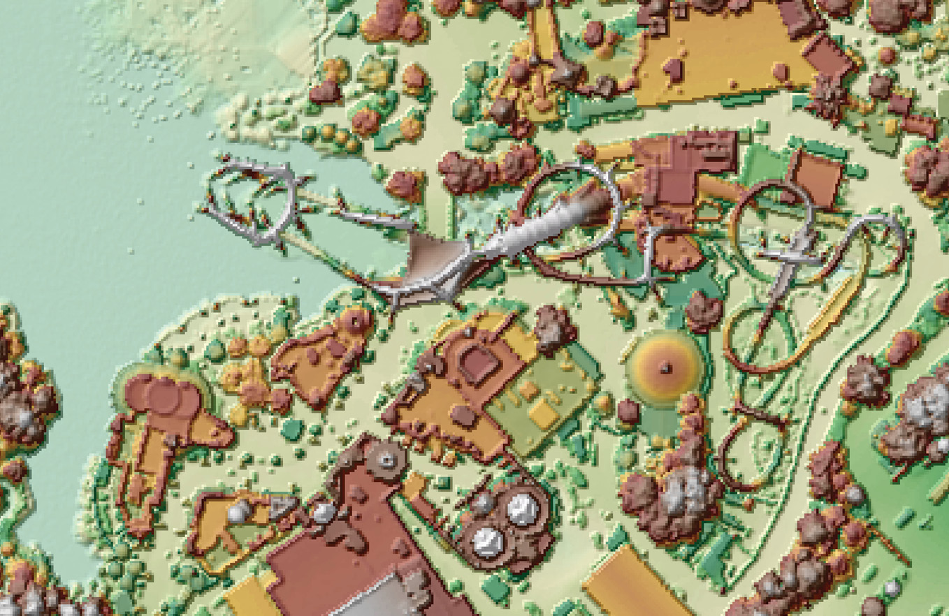
Figure 5: Lidar collections from the Leon County project—QL0 lidar point cloud showing Doak-Campbell Stadium, Tallahassee.
Dewberry has been providing lidar services to Leon County, Florida, since 2018. The county’s requirement for high-density, high-accuracy lidar to serve multiple county agencies led to the first ever countywide USGS QL0 lidar survey. In coordination with both USGS and Leon County, Dewberry acquired high-accuracy ground survey and lidar in 2018 (Figure 5), then processed and delivered the QL0 data to the county specifications in 20192.
Topobathymetric lidar
Nick Kules, a technology manager with Dewberry, presented several topobathymetric projects, again emphasizing the value of partnerships and the breadth of projects in which Dewberry has engaged. As a prime contractor on the USGS Geospatial Products and Services, the NOAA Coastal Geospatial Services Contract, and several state-level service contracts, Dewberry has conducted multiple topobathymetric lidar projects.
Topobathymetric lidar at the national and state levels
As part of a larger project on the Gulf Coast of Florida, Dewberry is assisting NOAA to map the bathymetry of Tampa Bay. In 2019, Dewberry used the Riegl VQ-880-G II to map the northern portion of the bay (Figure 6). The mapping was accomplished after several missions and included multiple re-flights to ensure complete coverage given the tidal and water clarity constraints. Additional mapping is scheduled for winter 2021 to map the southern portion of the bay.
Topobathymetric lidar at the state level
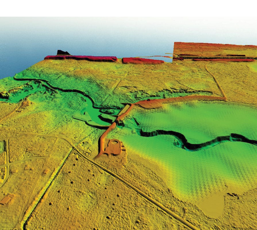
Figure 8: Above: DSM constructed from aerial lidar and single- and multi-beam sonar of the Ingles Lock and Dam, which forms Lake Rousseau on the Withlacoochee Rover, Citrus County, Florida. Below: DTM constructed from the same sources, showing the dredged channel in Lake Rousseau, the remains of the Withlacoochee River channel.
The Southwest Florida Water Management District contracted with Dewberry to investigate the potential of using topobathymetric lidar to map submerged aquatic vegetation and the bathymetry in the Rainbow Springs Aquatic Preserve. This project was captured with NOAA’s Riegl VQ-880-G in the spring of 2018. Refraction corrections were made based on a water surface determined by USGS water level gages and the results were delivered as both a DTM (Figure 7) and a classified point cloud. Profiles through the point cloud were used to determine vegetation canopy.
Topobathymetric lidar at the local level
 Dewberry has been working with several state agencies to integrate elevation data from multiple sources into seamless DTMs. For the Lake Rousseau-Withlacoochee River minimum flows and level (MFL) modeling, Dewberry used multibeam sonar to measure the bathymetry of a dredged river channel and area near the Ingles Lock and Dam that formed Lake Rousseau (western area on the figures below); conventional single-beam hydrographic survey sonar and advanced surface modeling techniques along the flooded lake outside of the channel; and USGS QL1 terrestrial lidar through the floodplain. These data sources enabled the firm to construct a seamless elevation model for the MFL along the seven-mile length of the backwater lake (Figure 8).
The above projects demonstrate the value of partnerships between federal, state, and local agencies and municipalities with Dewberry, as well as the range of projects and uses for topographic and topobathymetric lidar.
Amar Nayegandhi, CP, CMS, GISP is vice president and director of remote sensing at Dewberry. He oversees the Geospatial and Technology Services line for Dewberry’s contracts with federal, state, and commercial clients. With over 20 years of experience, he is a recognized expert in topographic and bathymetric lidar data acquisition and processing. Amar has a bachelor’s degree in electrical engineering from the University of Mumbai and a master’s degree in computer science from the University of South Florida. He is the director of the ASPRS Lidar Division, an ASPRS Certified Photogrammetrist and Certified Mapping Scientist – Remote Sensing, and a GIS Certification Institute Professional.
Nick Kules is a geospatial technology manager in Dewberry’s Tampa office, responsible for overseeing geospatial process development, tool and scripting development, and providing technical guidance for remote sensing projects. Mr. Kules is experienced in geospatial software and tool development in C++ and Python, as well as systems integration of software and hardware solutions for processing workflows. He is experienced in processing and calibrating both topographic and bathymetric lidar sensors and data. Mr. Kules also has extensive experience with ArcGIS, MicroStation, POSPac, Inertial Explorer, and with extraction software related to Teledyne Optech, Leica Geosystems, and Riegl sensors. Mr Kules is currently a director of ASPRS Florida Region.
Alvan “Al” Karlin, PhD, CMS, GISP is a senior GIS professional at Dewberry, and was formerly with the SWFWMD, where he managed all the remote sensing and lidar-related projects in mapping and GIS. With Dewberry, he serves as a consultant on Florida-related lidar and imagery projects, as well as general GIS-related projects. He has a Ph.D. in computational theoretical genetics from Miami University in Ohio. He is the immediate past president of the Florida Region of ASPRS, an ASPRS Certified Mapping Scientist—Lidar, and a GIS Certification Institute Professional.
1 Maune, D.F. and A. Nayegandhi (eds.), 2018. Digital Elevation Model Technologies and Applications: The DEM Users Manual, 3rd edition, American Society for Photogrammetry and Remote Sensing, Bethesda, Maryland, 652 pp.
2 Karlin, A., R. Miller, A. Nayegandhi and G. Mauldin, 2020. Florida-Based land surveyors achieve QL0 lidar scan for GIS landbase update, Point of Beginning, 45(12): 21-26, October 2020.