The Routescene UAV LiDAR system mounted under the Skyfront Perimeter 8 drone undergoing endurance testing in California.
11 March 2021 – Small improvements to a drone LiDAR survey can make big differences in efficiency, productivity and safety. A major limiting factor for any UAV survey is the drone’s battery life which, along with the weight of the payload, impacts on the drone’s flight time. Imagine the improved productivity and scope of work which could be undertaken if the drone’s flight time could be significantly increased.
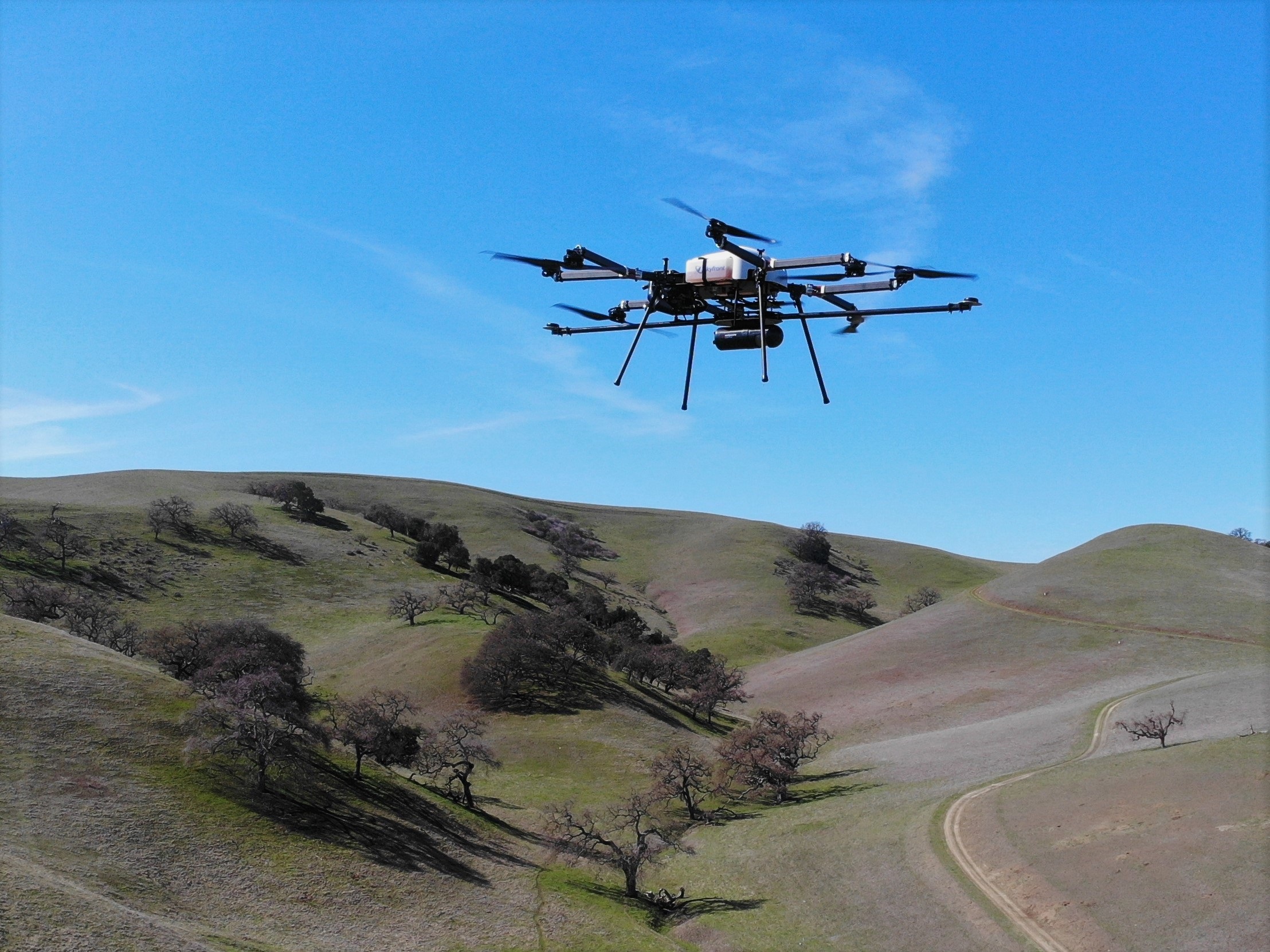
Skyfront and Routescene explored the impact on productivity of using the longest endurance gasoline-electric hybrid multicopter drone, the Skyfront Perimeter 8.
The impact of reducing downtime
Typically a drone utilising lithium polymer batteries, such as a DJI M600, and carrying a 3.3kg payload (for example a Routescene UAV LiDAR system) would operate with a flight time of around 15-20 minutes. Landing, replacing the batteries and take-off between each flight can take longer than the flight itself, directly influencing the size of the survey area that can be flown each day.
To compound this larger survey sites may require multiple take-off and landing sites, which means all the equipment needs to be moved from one site to the next, further limiting the number of flights in a day. The Skyfront and Routescene teams knew that increasing flight times, thereby reducing the unproductive time in a survey day, could significantly impact on data collection productivity.
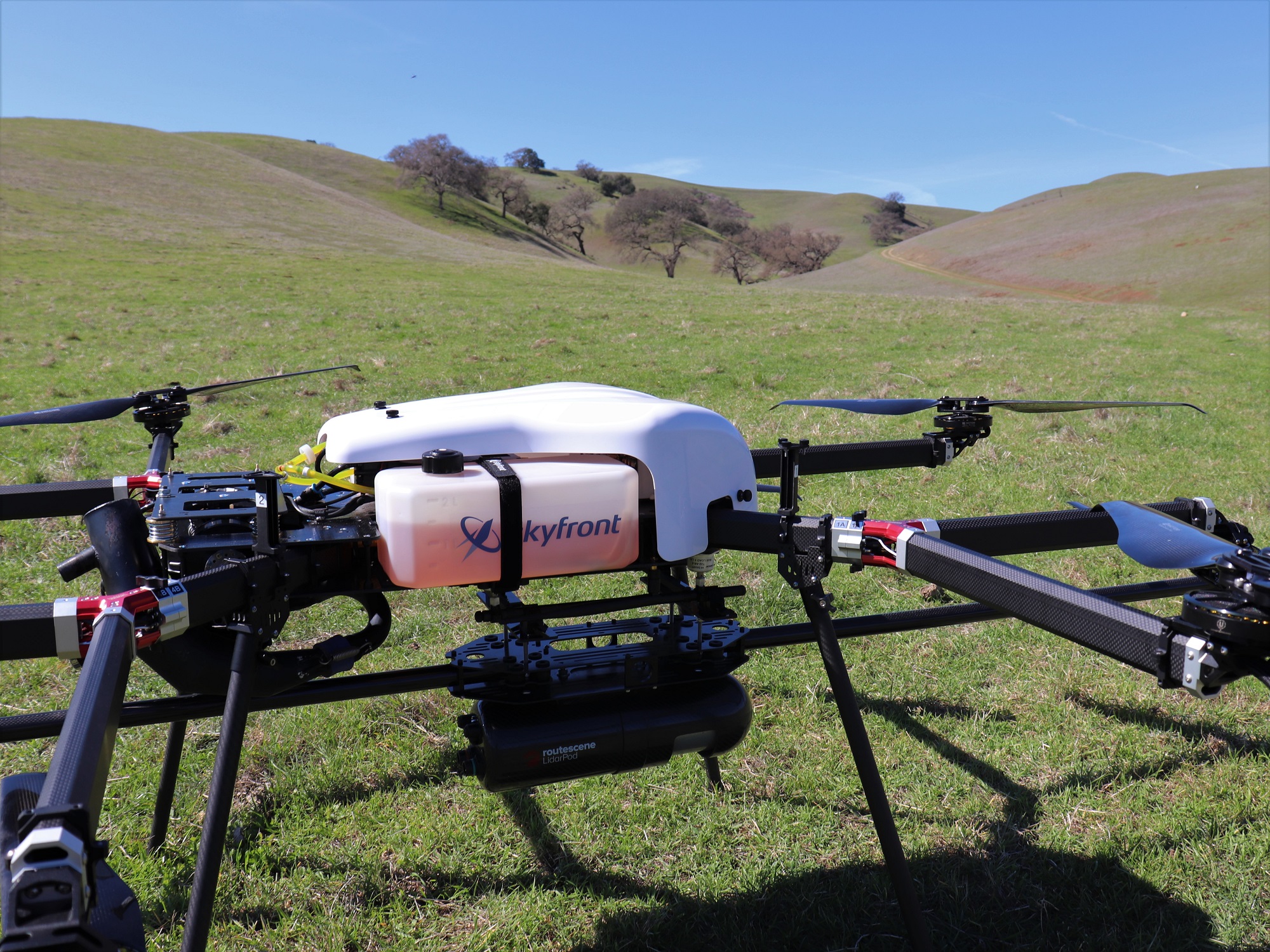 The teams tested the Skyfront Perimeter 8 drone carrying a Routescene UAV LiDAR system at the Skyfront headquarters in Menlo Park, California, USA. The Skyfront Perimeter 8 is an eight rotor hybrid UAV designed for carrying heavier payloads such as LiDAR. The Perimeter 8 has both rotor and complete engine redundancy for safety. The results: the Perimeter 8 drone was able to fly for a total of three hours carrying the Routescene payload.
Gert Riemersma, Founder and CTO of Routescene, commented, “Through this testing the team found the greatest benefit gained was regarding efficiency. Due to the longer flight times, only one take-off and landing site was required, removing the need to travel between sites to repeatedly set up. In addition, a considerable amount of time was saved simply by eradicating turn-around times to replace batteries. We estimated that by achieving 3 hours of flight time at 5m/s you can readily cover 54 survey line kilometres, or just over 500 acres. This is equivalent to roughly 10 x M600 flights, which would normally take two days to complete. An impressive result, reducing two days of surveying into less than one day, simply by eliminating downtime.
The Routescene UAV LiDAR system has been designed to maximise productivity, with a solid state disc onboard capable of storing over 13 hours worth of data, more than enough for a full day in the field. The quality of the data being collected is monitored in real-time during the entire drone survey using Routescene’s QA Monitor, a web based app, to make sure you leave the survey site with the data you need. At the end of the survey the data can be downloaded and checked in the field using Routescene’s LidarViewer Pro data processing software.
Gert added, “Routescene has a strong ethos of quality assurance and quality control (QA/QC). Implementing rigorous QA/QC improves data quality and efficiencies. QA Monitor gives you confidence in the data you are collecting while you are collecting it. The last thing you want after completing a long survey flight is to realise there was an issue and the team has to mobilise to fly the area again. It prevents time being wasted, you can identify an issue immediately, remedy it there and then in the field, bringing further efficiencies to the increased gains brought by longer flight times.”
The significance of longer flight times
Longer flight times have a positive impact on safety too. The riskiest parts of a UAV flight are the take-offs and landings, when the drone is under manual control and hence when accidents are most likely to occur. Reducing the number of take-offs and landings obviously directly reduces the probability of an accident.
Brian Maxwell, VP of Business Development at Skyfront, confirmed, “Our flight time of 3 hours was particularly impressive and allowed a huge volume of 3D data to be collected efficiently. We found that we could considerably improve the resilience, efficiency and safety of UAV LiDAR surveys by increasing the flight time.”
Christian Andresen from the University of Wisconsin added, “In 2017 and 2018 we surveyed areas of the Arctic as part of the NGEE Arctic project researching changes to permafrost and ecosystem structure. What we observed over the 2 years whilst working there was how much drone technology improved and the positive impact that had on flight times. The Arctic location was exceptionally remote and all incremental improvements make a huge difference to our efficiency and reduce time spent in the field. A drone that could fly for 3 hours would make a dramatic difference for our future surveys in this remote area.”
For more information on the Skyfront Perimeter 8 drone and Routescene UAV LiDAR system, please visit www.routescene.com and www.skyfront.com.
About Routescene®
The Routescene UAV LiDAR turnkey solution is designed specifically for use on Unmanned Aerial Vehicles (UAVs or drones). Developed to save time, improve efficiencies and productivity. It enables faster surveys and higher resolution outputs with Quality Assurance as standard. Perfect for applications where accurate mapping is essential but difficult to achieve such as hard to reach areas, hazardous environments and situations where you need to penetrate vegetation to reach the ground beneath. All the complex integration is complete. The result is an operational system ready for immediate use. Comprising workflow methodologies, quality assurance software, post-processing software, hardware and firmware. Routescene® is a global operation. We offer authoritative insight across all aspects of data management and have industry recognition as data visualisation experts. We understand the problems the survey industry needs to solve and have combined intelligent thinking with experience to design a reliable and practical solution to deliver fast geospatial data capture, analysis and visualisation to improve commercial decisions and performance.
About Skyfront
Skyfront hybrid UAVs are built for maximum endurance—from mission-critical search and rescue to the latest commercial applications. Skyfront Perimeter multirotor drones are designed to fly beyond visual line-of-sight (BVLOS) more than 60 miles away to monitor, detect, and explore for a fraction of the cost of a manned helicopter. The company solves the previous limitations in mapping and surveying applications with increased payload ability. Skyfront is mission ready and deployed worldwide. To learn more about Skyfront Perimeter drones, visit www.skyfront.com
