Firm to provide geospatial and technology services to help plan and implement the Alaska Coastal Mapping Strategy.

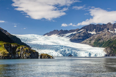
Aialik Glacier in Kenai Fjords National Park is an example of the challenging topography facing coastal mapping in Alaska. Photo courtesy of www.dorevorum.photography.
Fairfax, VA—February 10, 2021 – Dewberry, a privately held professional services firm, has announced that the National Oceanic and Atmospheric Administration (NOAA) has awarded the firm a task order to assist in the implementation of the 2020 Alaska Coastal Mapping Strategy (ACMS). ACMS is a product of the Alaska Mapping Executive Committee (AMEC), an interagency federal and state partnership in which NOAA is a participant. ACMS addresses the need for coastal and nearshore elevation and imagery data to support Alaska, and federal coastal mapping, for products such as NOAA nautical charts and the need for a seamless topobathymetric 3D surface with both underwater bathymetry and onshore topography.
In coordination with NOAA, including the National Geodetic Survey (NGS), Office of Coast Survey (OCS), Office of Coastal Management (OCM), other federal agencies, the state of Alaska, local, and native entities, the firm will provide planning, coordination, management, and technology research services.
“Implementing the ACMS continues momentum forward on coordinated mapping of Alaska’s coasts and nearshore waters. These data are critical for many reasons, from informed management of coastal lands and trust resources to safe navigation, responsible energy exploration, and climate change mitigation strategies,” says NOAA’s Integrated Ocean and Coastal Mapping Coordinator Ashley Chappell.
“This effort will go a long way in supporting the finalization and implementation of the ACMS,” says Dewberry Associate Vice President and Senior Program Manager Mark Safran, CP, GISP. “Accurate mapping data will help many coastal communities that are without decent map information, which is crucial for dealing with coastal hazards like flooding and erosion.”
Hillary Palmer, Alaska-based Dewberry project manager and co-chair of the Alaska Geospatial Council Transportation Working Group, is leading this effort.
“This much needed coastal mapping will play an enormous role in supporting safer maritime navigation and better emergency planning,” says Palmer.
About Dewberry
Dewberry is a leading, market-facing firm with a proven history of providing professional services to a wide variety of public- and private-sector clients. Recognized for combining unsurpassed commitment to client service with deep subject matter expertise, Dewberry is dedicated to solving clients’ most complex challenges and transforming their communities. Established in 1956, Dewberry is headquartered in Fairfax, Virginia, with more than 50 locations and 2,000+ professionals nationwide. To learn more, visit www.dewberry.com.
