
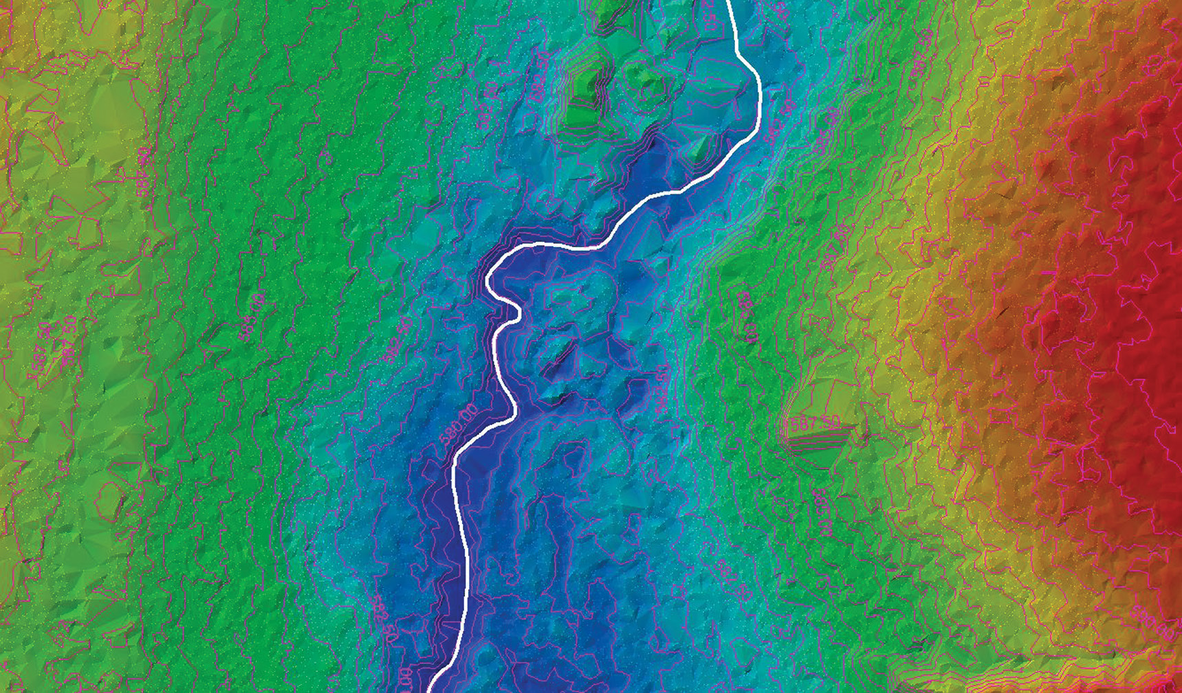
Figure 1: An example of a hydro-enforced dataset created from publicly available high-resolution lidar data and aerial orthophotography. Image courtesy of CivicMapper.
Across the United States, state and local government agencies are funding the collection of lidar data to create high-resolution, high-accuracy digital elevation models. The availability of these and other open geospatial data has enabled workers to derive detailed information about terrain and land cover that can be used to inform new hydrologic models for use in stormwater management. The availability of quality level 2 (QL2) lidar data and corresponding high-resolution digital orthophotographs provides an excellent starting point for creating hydrologic surfaces used for characterizing hydrologic basins in urban environments (Figure 1).
Editor’s note: A PDF of this article as it appeared in the magazine is available HERE.
Understanding hydrologic systems and the capacities of stormwater infrastructure is more important than ever. More frequent and severe storm events in the US are predicted to increase over the 21st century (Wuebbles et al, 2017), causing additional strain on the nation’s aging stormwater infrastructure. In the eastern United States, dozens of cities received record rainfall in 2018 and 2019, and winter rainfall records were broken across the southeastern US in 2020. More stormwater, combined with an estimated $105 billion investment gap through 2025 for water and wastewater infrastructure (ASCE, 2016), creates an extremely challenging problem for areas that are already suffering from the effects of a changing climate. It is therefore critical that these increasingly severe wet-weather events are better understood by local governments and regional authorities so that the disastrous effects of these storms on our communities can be mitigated (Mercurio, 2020). Though it is only part of the solution, the use of high-quality lidar data to create a digital twin of terrain provides a basis for modeling the accumulation and flow of water within a catchment basin.
The USGS 3DEP program
Development of hydro-processed digital elevation data for a whole state can be a lengthy process complicated by the timing of new lidar collections and the limited resources of available staff. To respond to the growing need for high-resolution elevation data, the USGS 3D Elevation Program (3DEP) was formed in 2014 for the purpose of acquiring a nationwide high-resolution elevation dataset by 2023. Under 3DEP, lidar data is being collected for many parts of the country, in most cases at QL2. The data will be available for use through public repositories. At the minimum, the user will have access to classified LAS files and USGS-based hydro breaklines. Since the data go through a QA/QC process, adjacent areas will be produced to the same data quality standards, allowing for the expansion of models to regional scales.
By May 2020, data from 3DEP was available or in preparation for more than 60% of the US, with many additional lidar collections planned (USGS, 2020a). Publicly available lidar, other high-resolution elevation data, and imagery datasets facilitate the understanding of hydrologic systems and inspire innovation in the earth sciences. The use of this data in hydrologic models and basin characterizations helps communities become more resilient to the impact of climate change, and provides some of the most powerful tools that professionals can use to quantify the impacts of stormwater on aging infrastructure. Smarter decisions in stormwater management can be made and the destructive toll from flooding caused by more frequent and severe storm events can be limited. The return on investment of the 3DEP program has been estimated at 5:1 (USGS, 2020b), with the potential to provide more than $690 million annually in new benefits to government entities, the private sector, and citizens.
Improving hydrographic mapping with lidar
Publications from the USGS and books such as The DEM Users Manual (Maune and Nayegandhi, 2018) give excellent definitions and descriptions of hydro-flattening, hydro-conditioning, and hydro-enforcement of digital elevation models. The data development processes help make sure that the behavior and movement of water across terrain are accurately represented in hydrologic models.
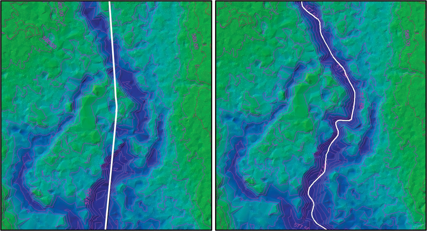
Figure 2: These images show a high-resolution lidar dataset of the same stream corridor. The image on the left is overlaid with the existing National Hydrography Dataset (NHD) flow line representing the stream. The image on the right is overlaid with a revised flow line that more accurately represents the stream centerline for this corridor with respect to the new lidar-derived elevation model. Image courtesy of CivicMapper.
The role of breaklines in hydrologic data processing workflows is essential for developing a quality product. Breaklines are vector features (lines and polygons) that are created to safeguard the accuracy and cartographic quality of a topographic data product such as a digital elevation model (DEM) or orthophotograph. Topographic datasets differ greatly in the specification and accuracies to which they were collected and there is a wide range of complexities in each collection area (Figure 2). As a result, there is no “one size fits all” solution for every project when applying breaklines for improving lidar data. Specifically, hydro-flattening is the processing of a lidar-derived surface (DEM or TIN) so that mapped water bodies, rivers, reservoirs, and other cartographically polygonal water surfaces are flat and, furthermore, level from bank to bank on a sloping surface. The use of breaklines ensures a flattened bank-to-bank appearance of rivers and streams, as well as a consistent downward slope referred to as “monotonicity.” Also, breaklines undergird the proper processing of contour lines that do not cut across water bodies and closely delineate and portray rivers and streams. Currently, based on the USGS specifications, the creation of hydro breaklines primarily involves capturing rivers with width 100 ft or more and lakes/ponds more than 2 acres in size.
The incorporation of breaklines to impose continuous downward sloping of water flow is termed hydro-enforcement. A dataset that has been hydro-conditioned means that the entire surface of the digital elevation model has been processed so that the flow of water across the surface of a landscape will be continuous, even if it is outside the stream channel. When a dataset has been hydro-conditioned, catchments can be created and linked to neighboring catchments, effectively allowing for pour points to be modeled at any location within the basin.
Rather than simultaneously hydro-correcting data for a whole state, some regional agencies and local organizations are choosing to hydro-correct their elevation data on a watershed, sub-watershed, or project basis with the intention of making the data public and shareable once ready for publication. This approach can save time and costs, and also guarantees that the best available data will be used for basin characterizations that depend on high-quality and hydrologically corrected elevation models.
Basin characterization for local projects
Hydrologic basin characterization is a model-based method for quantifying the volume of stormwater entering and exiting a catchment, based on a variety of geospatial datasets and climate data including elevation, land cover, soils, and predicted rainfall. Results from hydrologic basin characterizations can be used to improve stormwater engineering plans and determine whether existing stormwater infrastructure is adequately sized for predicted storm events (e.g., 2-year, 5-year, 10-year storms). Impervious surfaces like pavement, roofs, and parking lots prevent the absorption of stormwater and create runoff that not only affects water quality but also exacerbates flooding in lower-lying areas. Identifying the location and change of impervious surfaces over time is critical for developing accurate basin characterization models. The estimates of impervious surface cover also serve as the basis for stormwater fee assessments in many communities, especially where these fees correspond to the percentage of impervious surface that covers a parcel.
Urban watersheds are prime targets for hydrologic basin characterization. They are the most impacted by climate and aging infrastructure and need to be better understood to protect people, property, and the environment. Hydrologic basin characterization in urban watersheds can also precede more resource-intensive stormwater management models (SWMM). For example, peak flow volume models such as TR-55 (Cronshey, 1986) can provide a lower-cost approach for characterizing smaller urban watersheds and for developing a set of key data that can be used in other analyses within the basin, including input to SWMM.
The availability of open, QL2 lidar and imagery across many states means that local and regional organizations have access to some of the most powerful sources of information for understanding urban hydrologic systems. Assistance from skilled private-sector partners can help fast-track hydrologic and basin characterization projects as well as provide guidance on future hydrographic data initiatives. Thanks to 3DEP data, there has never been a better time to start!
References
ASCE, 2016. Failure to Act: Closing the Infrastructure Investment Gap for America’s Economic Future, American Society of Civil Engineers, Reston, VA, 32 pp. https://www.infrastructurereportcard.org/wp-content/uploads/2016/05/2016-FTA-Report-Close-the-Gap.pdf.
Cronshey, R. et al, 1986. Urban Hydrology for Small Watersheds: TR-55, USDA, 210-VI-TR-55, 2nd edition, 164 pp, June 1986
Maune, D.F. and A. Nayegandhi (eds.), 2018. Digital Elevation Model Technologies and Applications: The DEM Users Manual, 3rd edition, American Society for Photogrammetry and Remote Sensing, Bethesda, MD, 652 pp.
Mercurio, E.C., 2020. Are your sewers GIS-ready?, Geospatial Solutions, February 26, 2020. http://geospatial-solutions.com/are-your-sewers-gis-ready/.
USGS, 2020a. 3DEP Data Acquisition Status Maps. https://www.usgs.gov/core-science-systems/ngp/3dep/3dep-data-acquisition-status-maps.
USGS, 2020b. 3DEP By The Numbers. https://www.usgs.gov/core-science-systems/ngp/3dep/3dep-numbers.
Wuebbles, D.J., D.W. Fahey, K.A. Hibbard, D.J. Dokken, B.C. Stewart and T.K. Maycock (eds.), 2017. Climate Science Special Report: Fourth National Climate Assessment, Volume I, U.S. Global Change Research Program, Washington, DC, 470 pp.