
OGC is a worldwide community committed to improving access to geospatial information. OGC serves as a trusted forum for discussion and development of interoperability solutions and free and open standards.
Lidar data is used to describe the real world or something existing at a location in the real world. The collected lidar point clouds are referenced to the real world and must often be considered in the context of other data used to represent features observed by other means. This means that lidar point clouds must be interoperable in a geospatial context with other information. Making this happen is the job of Open Geospatial Consortium (OGC) standards and innovation activities.
Editor’s note: A PDF of this article as it appeared in the magazine is available HERE.
Founded in 1994, OGC is an international consortium of more than 500 businesses, government agencies, research organizations, and universities driven to make geospatial (location) information and services FAIR—Findable, Accessible, Interoperable, and Reusable. OGC’s member-driven consensus process creates royalty-free, publicly available, open geospatial standards1. OGC operates a Standards Program to identify requirements for standardization and to publish resources such as Best Practices to describe the use of standards in real-world cases, user guides, developer resources, and content registries to aid in delivering interoperability solutions. Closely linked with this standard-development process is the OGC Innovation Program, a forum for OGC members to solve the latest and hardest geospatial challenges via a collaborative and agile process. OGC members (sponsors and technology implementers) come together to solve problems, produce prototypes, develop demonstrations, provide best practices, and advance the future of standards. Influencing both programs is a Technology Forecasting process led by OGC’s CTO with engagement and review from OGC membership.
Within OGC, there are many groups that span a wide spectrum of domains. Standards Working Groups (SWGs) build and advance standards and supporting resources. Domain Working Groups (DWGs) serve as forums for discussions on topics around technical or practice areas that may lead to eventual standardization. In early 2015, however, a question was raised asking where point clouds fit into the OGC ecosystem. After discussion, it was clear that there was a need for a dedicated forum for debate regarding point-cloud data. In June 2015, therefore, OGC membership formed a Point Cloud Domain Working Group to discuss use cases, requirements, and capabilities for the collection, storage, and dissemination of point-cloud data from any source. This DWG was motivated by the fast-growing popularity and use of point-cloud technology. Naturally, lidar is perhaps the most abundant source of the data. This article serves to highlight the work to date of the DWG and identify opportunities to improve the lidar business through the smart application of standards and consensus.
OGC standards in action
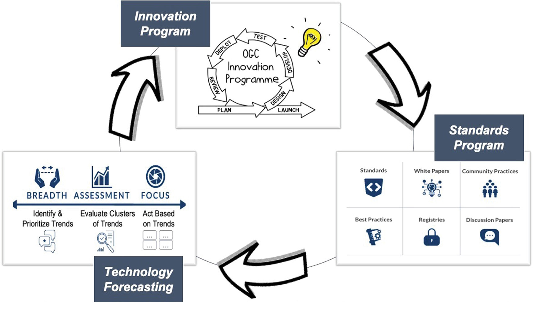
OGC continuously monitors emerging technology trends through a forecasting process to identify priorities for further investigation in the OGC Innovation Program as well as for consideration in standardization. The Innovation Program operates as a lab to incubate new standards topics as well as to test interoperability solutions that lead to improved standards.
OGC standards enable the power of location. The majority of databases and geospatial specifications rely upon the underlying model of OGC Simple Features standard to store vector data. Standards such as the Web Map Service (WMS) and OGC API—Features allow for dissemination of information in a consistent way to web-connected users. Other standards, such as the Geography Markup Language (GML) and Keyhole Markup Language (KML), provide a means to exchange geospatial data.
OGC standards are built to be interoperable such that data can be explored and disseminated in the manner best addressing a user’s needs. It is paramount that the information be discoverable and predictably made available for view or further analysis. In assessing the variety of point-cloud encoding standards and specifications, OGC members realized that there were gaps in putting together a fully interoperable value chain from data collection through management to derived products.
The goals of the Point Cloud DWG
Before the DWG could begin its work, it was important to define the mission and goals to guide future activities. The DWG members arrived at a mission to broaden the understanding of point-cloud data interoperability requirements and use cases and to help drive activities to improve interoperability in the community.
As part of its charter, the DWG set forth the following goals to help establish the direction of its activities.
- Understand implementation barriers for point-cloud communities and document those barriers in a format that can guide future technology design.
- Identify interfaces and information encodings that complement the existing OGC standards but are directly tailored to the requirements discovered in understanding the needs of the point-cloud user community.
- Promote the development of OGC Best Practices and standards to meet the point-cloud domain objectives. Candidate standards may come from external, market-established standards or from anticipatory standards developed in OGC initiatives.
- Efforts should focus on working point-cloud issues and problems that result in a net gain for the community. In other words, efforts should help create interoperability without placing hurdles in front of the amazing innovation happening in the point-cloud community.
- Define the supporting infrastructure for the community to achieve these goals.
Thus the DWG would serve as: a forum within OGC for point-based data; to present, refine and focus interoperability-related point-cloud issues to the OGC membership; and to serve where appropriate as a liaison to other industry, government, research, and standards organizations active within the point-cloud domain.
Work so far
 Because point clouds are being used in so many domains and use cases, the DWG was quickly inundated with ideas and potential goals for the group. So the chairs of the DWG, Jan Boehm of University College London, Stan Tillman of Hexagon, and Peter van Oosterom of Delft University of Technology, decided to put out a survey to the entire community (both internal and external to OGC) to better understand how point clouds were being used. The survey received an encouraging 163 responses, each from a different organization. This was a very enlightening exercise, giving the DWG a variety of information including sources, formats, use cases, application areas, storage, attribution, data volumes, and tools. But, most importantly, the DWG was able to learn about the interoperability challenges facing the community. The following highlights emerged:
- Interoperability is a challenge at all stages of handling of point-cloud data;
- The biggest challenges come from analysis, dissemination, and acquisition; and
- The biggest concern in the community centers around web service protocols, data models, and file formats/encodings.
After discussing results of the survey during sessions at the OGC Technical Committee meetings, it became clear that members did not want to invent a new encoding, but rather provide Best Practices for the use of existing encodings and perhaps endorsement of select encodings. It was also decided that we did not have enough knowledge to begin a service standard—the fear was that creating one too early would hinder innovation.
In response to this initial investigation, two activities began to form:
- Community Standards are OGC Member-endorsed standards that were developed and are managed external to OGC. For instance, OpenFlight is a 3D modeling specification originally developed by a commercial entity (Presagis), but which has been made available on a free basis to anyone and approved by OGC Members as being an important part of the overall geospatial standards baseline. There are three highly relevant specifications that have been adopted as OGC Community Standards.
- LAS 1.4 is the fourth revision of the point-cloud binary format for laser-scanned data (LASer). Although ASPRS still maintains ownership of the LAS specification, OGC has adopted it as a recommended point-cloud encoding.
- 3D Tiles is a specification from Cesium, Inc. containing a data structure organized in support of streaming and rendering 3D geospatial content, including textures, solids, triangles, and point clouds.
- Esri I3S is for streaming large 3D datasets and is designed for performance and scalability. I3S supports 3D geospatial content and the requisite coordinate reference systems and height models, in conjunction with a rich set of layer types. The point-cloud portion of I3S represents a static tile set with data organized in separate files by attribute type. It is expected to be consumed by web clients over the internet. It is suitable to feed a browser-based renderer or data processing software, and it can be configured to store data in a lossless configuration.
- Vendor Summits allow the DWG to host demonstrations by vendors of their current point-cloud technologies centered around a given theme. Typically, OGC Working Groups do not encourage promotion of product materials. In this case, however, it is important to understand the capabilities that already exist in the community. These Summits have included private companies, open-source groups, government agencies, and academia. To date, the DWG has hosted two such summits that covered the themes of streaming point clouds and visualization
of point clouds.
What’s next?
 Where is the DWG going next? We plan to continue to host the Vendor Summits around themes such as storage, as well as keeping an eye out for additional proposals for Community Standards.
We are also beginning to learn enough from the community to propose a standard web service for the exchange of point-cloud data. We have seen that organizations like to control the content, format, and organization of the data. But perhaps a web service could be defined to standardize the delivery mechanism of the point-cloud data. This would be very similar to how traditional OGC services have been defined. The server can organize and store the data in any desired format while supporting one or more transfer encodings. Then the client would request the desired encoding based on what is available from the service. Obviously, there are many more details, but the next step would be to define a set of principles and goals for such a service and write a charter describing the creation of a new Standards Working Group to create the standard.
Conclusion
Whether it be charting shipwrecks on the ocean floor, mapping underground mines and caves, or enabling automated transportation systems to avoid obstacles, the use of point clouds is going to increase at a very high rate. Thus the Point Cloud DWG is working to harness the excitement, encourage the innovation, and propose the standardization for all of the systems
to work in harmony.