Automated 3D Point Cloud Extraction
As the capture and processing of rich 3D point cloud data becomes more common, tools to efficiently extract information are critical to maximize productivity. To satisfy this need, Trimble Business Center 5.40 introduces eCogAI™ software library, a fusion of Trimble’s eCognition technology and state-of-the-art Deep Learning AI, which automates the extraction of information from 3D point cloud data. The powerful new tools dramatically reduce the time to create CAD and GIS linework and objects that are used to generate topographic plans, surface models and GIS database layers.
Civil Infrastructure and Tunneling Applications Provide Additional Data Types
Trimble Business Center 5.40 introduces a new Monitoring module that integrates deformation information from Trimble T4D Control™ software. The new capabilities provide surveyors with the ability to view all relevant survey data within a single project environment, enabling quicker and more informed decisions for civil infrastructure and mining applications.
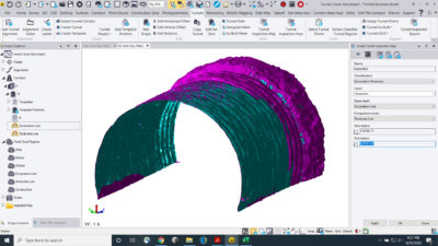
For tunneling applications, enhancements to the Tunneling module allow surveyors to rapidly compare 3D point cloud data of the construction progress with the tunnel design. With an automated tunnel extraction routine and detailed mesh comparison models, the new capabilities significantly reduce the effort to generate highly graphical as-built reports to enable rapid construction verification.
New Subscription Plans
The new subscription plans enable businesses to more effectively manage and control their operating expenses. With new license management tools, administrators can assign licenses to individuals—efficiently matching software capabilities to personnel skills and project needs.
“With the addition of Monitoring and Tunneling modules and the new feature extraction capabilities, customers now have access to powerful new tools that enable them to start and stay in one software,” said Tim Lemmon, marketing director, Trimble Geospatial Software. “The new subscription plans make Trimble Business Center even more accessible for survey and construction professionals, allowing them to better manage and scale their capabilities as their business grows.”
Trimble Business Center version 5.40 is now available through Trimble’s Geospatial Distribution Partners. The subscription plans are expected to be available in the first quarter of 2021. For more information, visit: geospatial.trimble.com/tbc.
About Trimble Geospatial
Trimble Geospatial provides solutions that facilitate high-quality, productive workflows and information exchange, driving value for a global and diverse customer base of surveyors, engineering and GIS service companies, governments, utilities and transportation authorities. Trimble’s innovative technologies include integrated sensors, field applications, real-time communications and office software for processing, modeling and data analytics. Using Trimble solutions, organizations can capture the most accurate spatial data and transform it into intelligence to deliver increased productivity and improved decision-making. Whether enabling more efficient use of natural resources or enhancing the performance and lifecycle of civil infrastructure, timely and reliable geospatial information is at the core of Trimble’s solutions to transform the way work is done. For more information, visit: geospatial.trimble.com.
About Trimble
Trimble is transforming the way the world works by delivering products and services that connect the physical and digital worlds. Core technologies in positioning, modeling, connectivity and data analytics enable customers to improve productivity, quality, safety and sustainability. From purpose built products to enterprise lifecycle solutions, Trimble software, hardware and services are transforming industries such as agriculture, construction, geospatial and transportation. For more information about Trimble (NASDAQ:TRMB), visit: www.trimble.com.