
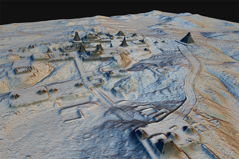
Bordered on the north and west by Mexico and on the east by Belize, the lush forests of Guatemala’s Petén region have long been recognized as a treasure trove of archaeological discovery. The area is home to the Maya Biosphere Reserve, where archaeologists have spent decades studying remnants of ancient Maya civilization. A recent discovery overturned everything they thought they knew when more than 61,000 Maya structures were detected beneath a thick green veil of trees and vines.
Astonished researchers found not just a few new sites, but thousands of Maya structures revealed by lidar sensors and displayed on GIS maps. Lidar data was collected across the region in a day, and it took the team several months to produce a comprehensive 3D map that unlocked a whole new view of the area’s past.
Marcello Canuto, director of the Middle American Research Institute and professor of anthropology at Tulane University, was part of the research team. He recalls his surprise when he viewed the lidar imagery of his favorite jogging path through the ancient Maya site where he conducts research.
“Part of my trail ran up, on, and along an elevated area on the site,” Canuto said. “I saw the lidar, I was like, oh my God, that’s a Maya road. I’d been jogging on this thing for several years and I had never recognized it.”
A new way to look at an ancient civilization
Viewing the lidar data, Canuto and his colleagues were confronted with a vast amount of raw architectural and settlement data and a host of compelling implications about the nature of Maya civilization. The lidar data, rich with thousands of newly discovered temples, homes, roads and more, clearly demonstrated a capacity to accommodate millions of people. Previous research had suggested much lower numbers. The revised estimation of local Maya population size in ancient times also shifted other assumptions about a tropical society with relatively small political centers.
In 2016, a team of researchers uncovered ancient cities in northern Guatemala through the use of jungle-penetrating lidar imagery. The project was funded by PACUNAM, Patrimonio Cultural y Natural Maya, Guatemala’s Maya heritage foundation. Courtesy of the American Association for the Advancement of Science.
“What does the old model imply? It implies nonurban. It implies low population. It implies a low degree of sociopolitical complexity and integration,” Canuto said. “Now we can say, that’s implausible, given the data of millions of Maya in this area.”
Among many other revelations from lidar data, the team was surprised by the scale of modification to the landscape for advanced farming, a complex system of raised roads and causeways enabling travel between urban centers, reservoirs, irrigation, and terracing indicative of a civilization accustomed to adapting to extremes of a tropical climate.
“We’re able to find the big sites, and then all the settlements,” Canuto said. “All the smaller houses, all the construction to create a society and an infrastructure that was built to improve their lives, to render the landscape more productive or less dangerous. That’s the part that is incredibly exciting for me.”
Learning more from lidar
Lidar can be used to generate precise, 3D information about the surface characteristics of the terrain and the vegetation that covers it. GIS maps of lidar collected in the Petén region led to the discovery of thousands of new features at an unprecedented pace. However, the speed with which lidar scans an archaeological site is only one of the ways it revolutionizes the field. Lidar also provides a comprehensive representation of infrastructure, both small and large—an especially useful insight for areas with heavy plant cover.
“There’s a real blind spot in the jungle,” said Canuto. “If I walk in front of a big temple that’s 20 meters high, I’ll see it… but what you can’t figure are monumental things over a prolonged space or distance, like a road.”
Lidar data collected in Petén may also help researchers understand and preserve Guatemalan heritage beyond the scope of archaeological research. While the technology was gathering details of ancient built structures, it was also amassing a vast store of data on the natural environment.
“We’re using five percent of all the lidar data. The other 95 percent is all the vegetation,” Canuto said. ”As archaeologists, we rarely look at the rest of that data. But there’s an amazing amount of information about the landscape that can also be used. Lidar captures a digital census of forest volume and forest type.”
Even within the scope of archaeology, lidar data can be helpful beyond its initial use. The same year Canuto and his colleagues were learning the true depths of Maya development in Guatemala, archaeologist Takeshi Inomata from the University of Arizona was investigating a site in Mexico using lidar data freely available online.
“Takeshi is excavating in Veracruz and Tabasco in Mexico at this massive site that was hiding in plain sight,” Canuto said. “It was so big and earthen in nature, that it just looked like a big mound. It’s of such massive size that an archaeologist would never say, ‘That’s a building.’ But when you see the lidar, it’s obvious.”
Shedding light on the distant past
Traditional archaeological study relies entirely on what researchers can see and find, with an ongoing goal of mapping an accurate landscape-scale view of every structure.
Until recent years, the process of locating and investigating sites for archaeological research had changed little. Most projects began with either a ground-level physical survey, in which researchers would flag any features or objects that indicated further investigation; or with a visual bird’s-eye survey, by plane or drone. Neither approach was capable of penetrating the dense forest canopies typical of Mayan settlements.
Lidar had been used by archeologists since the 1970s to map European castles and structures, but always in open areas and fields. It wasn’t until 2009 that lidar advanced enough to prove useful in jungle and forest settings. The landmark 2009 Caracol survey in Belize successfully penetrated heavy tree cover, revealing dozens of previously unknown structures and causeways and thousands of agricultural terraces in a fraction of the time a manual survey would have taken.
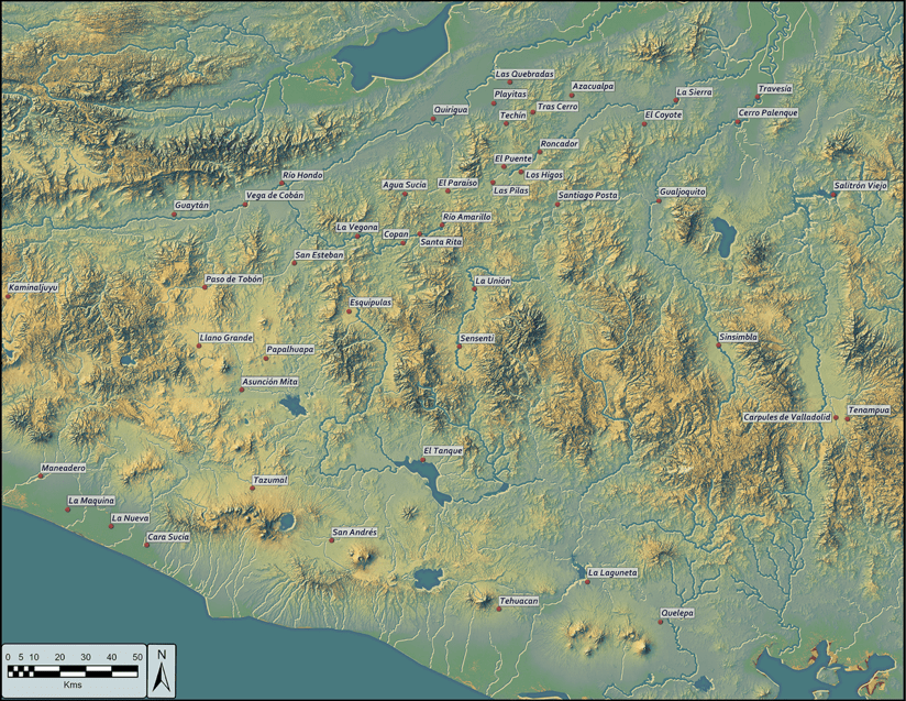
Marcello Canuto created this map to display the spread of found Mayan sites. Click on the image for a larger map.
The success of Caracol inspired researchers at the Foundation for Maya Cultural and Natural Heritage (PACUNAM), a Guatemalan organization focused on protecting the country’s natural and cultural heritage, to oversee the breakthrough lidar research in Petén. PACUNAM worked with the National Center for Airborne Laser Mapping at the University of Houston (NCALM) and NCALM aircraft carried cutting-edge lidar mapping equipment to create a comprehensive three-dimensional landscape of the Maya Biosphere Reserve.
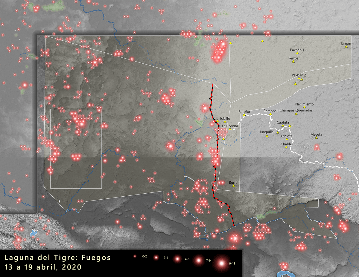
This map by Marcello Canuto displays widespread fires that took place in northwest Guatemala in April 2020. Click on the image for a larger map.
For research teams, GIS is integral to the process of recognizing and categorizing structural sites within lidar data. Archaeologists use GIS collection apps and interactive maps to compare various visualizations of the landscape, such as hillshading, relief maps and bonemaps, and identify features of interest. After adding map coordinates and other identification for each point, teams create a map to guide researchers to find and ground-truth the lidar data. The 3D view provided by lidar accelerates the process.
“An archaeological project might take 10 years to excavate, investigate, or map a site… you might get 20 or 30 square kilometers of mapping done over a period of decade if you’re really good at it,” Canuto said. “With lidar, suddenly you get precise data over 300 square kilometers within six months. It’s really quite amazing.”
Editor’s note: This is a republication of an article published by Esri on 17 November 2020. LIDAR Magazine is grateful to author Steve Snow.