The LAS Working Group’s (LWG) meeting on 16 November 2020 meeting focused primarily on the updated Classification Lookup Variable Length Record (VLR) proposed in Issue #82 and developed over the past year. If you aren’t familiar with VLRs, they are a means to customize and extend the LAS header with user-defined data such as lookup tables, indexing data and coordinate system definitions. Learn more in §2.5 of the specification.
Before we go into depth, let’s review some background of the LAS Classification Lookup VLR. The latest edition of the LAS 1.4 specification (Revision 15) includes the venerable Classification Lookup VLR (§4.1), which dates all the way back to the original publication of LAS 1.0 in 2003. The VLR is composed of a simple array of 256 16-byte blocks – one byte for each classification number and 15 bytes for each classification description (Figure 1).
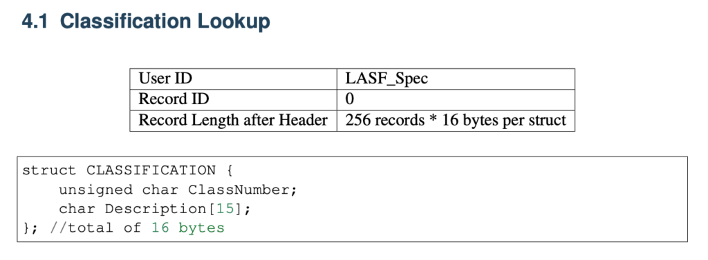
Figure 1: The current LAS 1.4 Revision 15 definition of the Classification Lookup VLR includes space for only 15 characters for classification names or descriptions, which isn’t nearly enough.
Despite its pedigree, the Classification Lookup VLR has been widely ignored for over 17 years. A brief survey of the community failed to produce a single person or example file using it. The reasons appear to be threefold:
- It is quite easy for the VLR to fall out of sync with the file contents.
- 15 bytes isn’t nearly enough for a description.
- It was never clear how to use the VLR, so external files were utilized instead, such as a README text file, metadata, reports and custom file formats for visualization software.
Nevertheless, the existence of external files with this exact information confirms its potential usefulness, particularly for handoffs of data between firms, departments or large data repositories, because external metadata is easily separated from the LAS. In addition, the meaning of each point classification is not always apparent in point cloud visualization software, and a lookup table is often helpful for human users attempting to interpret what they see.
The ASPRS Standard Point Class tables (Tables 9 and 17 in LAS 1.4 R15) attempt to add clarity by providing standard meanings of a range of values, such as “Ground” for Class 2. But many are intentionally vague and the precise interpretation will vary by application. For example, Classes 3-5 are reserved for Low, Medium and High Vegetation respectively. One application may define Low Vegetation as being 0.5-2.0 meters, while another may define it as 0.0-3.0 meters (Figure 2). Both definitions are equally valid.
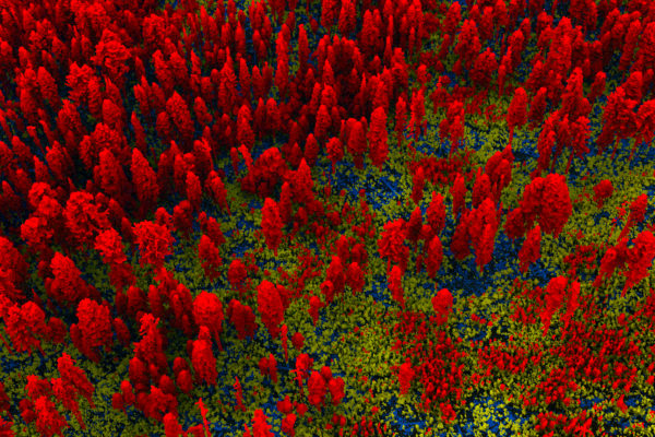
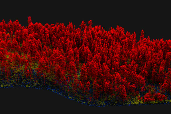
Figure 2: Forestry applications frequently require classifications of different vegetation layers, but the distinction between Low, Medium, and High Vegetation must necessarily vary between forest types. An updated Classification Lookup VLR v2 could provide a means for the LAS file to document itself.
The current proposal is to add a second version of the Classification Lookup VLR (v2) that allows for longer classification names and adds a description field for each classification.
In the November LWG meeting, therefore, we had significant discussion and disagreement over whether the lookup table should be allowed to deviate from the ASPRS Standard Point Class tables, i.e. whether point classes 0-63 (which are technically reserved for ASPRS) should even be allowed in the Classification Lookup VLR v2.
Arguments in opposition:
- Allowing deviation directly violates the existing specification, which explicitly requires compliance with the ASPRS Standard Point Class tables.
- Free-form classification names prevent machine interpretation of the classification table and therefore automatic filtering – e.g., a ground triangulation routine couldn’t infer which classification(s) to use.
Arguments in favor:
- Allowing deviation enables non-English speakers to override the classification names with the equivalent phrasing in their own language.
- There is already widespread usage of the reserved classifications throughout the industry, despite the requirement to adhere to the ASPRS Standard Point Class tables. This is particularly prevalent in legacy datasets preceding the current tables, or datasets utilizing LAS Domain Profiles.
Neutral arguments:
- The description field can be used to add clarity for a specific application without modifying the existing name or meaning in the ASPRS Standard Point Class tables.
- Entries in the VLR can include classifications not present in the LAS file, such as including Class 9 (Water) in an edge tile that doesn’t happen to have any water points.
The consensus as I understood it was that the purpose of the VLR is to provide clarity to human users who are interacting with the LAS file contents, particularly for the first time. Although the new VLR will allow user-defined entries for each of the ASPRS reserved point classifications, the specification must emphasize the importance of compliance with the meaning of the existing standard to improve interoperability.
Other action items
In addition to the above discussion, we received or refreshed the following specific action items:
- Create example LAS with the new classification table VLR.
- Close the existing ExtraByte thread and create a new one consolidating the previous discussions of standardized ExtraBytes.
- Fix typo in Table 17 header.
- Add wiki page for System ID.
Keep an eye on the ASPRS newsletter and the LAS homepage for the final review of LAS 1.4 Revision 16, which is expected to go forward for publication by the end of 2020.
Welcome new members
In November, the LWG welcomed new members Nick Kules (Dewberry), David Stolarz (ASPRS), Rupesh Shrestha (Oak Ridge National Lab) and Ezra Che (Oregon State University). These new memberships highlight the shift of the LWG’s composition from sensor manufacturers toward software developers and data users, which mirrors the natural shift of the remote sensing community from acquiring data to maximizing the utilization and value of point cloud datasets.
To join the LWG, you must be a paid member of ASPRS, so that the organization can continue its leadership position in the remote sensing community.
For those who haven’t been able to attend any of my presentations on the present and future of the LWG, the Oct/Nov 2020 issue of LIDAR Magazine includes an article on the inner workings of the LWG and LAS itself.