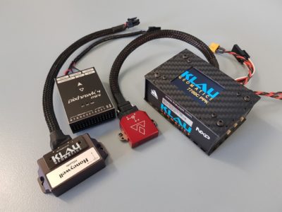
Klau Geomatics is releasing the 7700C integration platform, a GNSS hardware system designed to integrate with external IMUs and IoT devices.
The KlauPPK hardware/software product has been an industry leader in aerial mapping for over 5 years, with ongoing improvements leading to the release of the 7700C. The new 7700C system is a big step up in technology, offering connectivity to a range of external devices configurable through a user-accessible menu.
- PPP optimised NovAtel positioning technology with TerraStar-C Pro (3cm accuracy anywhere, with no base station) real time or near real time
- LCD screen and menu for user-enabled configuration
- Integration capacity to support various IMUs and other sensors with real-time or extremely precise post-processed GNSS/IMU options.
The new system is compatible with manned aircraft, UAVs and mobile mapping, for photogrammetry, LiDAR and other applications.
For typical aerial mapping, you can select from various cameras to capture photo timing and trigger the camera by user-defined distance or time. Connect to the flight management system on a drone to push real-time PPP corrected positions, allowing operators to navigate the drone with very high precision.
Connect the IMU of your choice with Klau Geomatics’ supplied cabling – from an accessibly priced Pixhawk, to Vectornav or high-end Honeywell. Handshake with the external IMU, send synchronisation data to the device and log the INS-processed or raw IMU data with the internal GNSS data in the KlauPPK unit for post-processing.
Connect other IoT devices. The KlauPPK 7700C is designed to enable custom integrations, to send position or data-sync out, and to log external data in.
From a simple lever arm correction on an aircraft to full blown IMU or INS integration for mobile mapping and LiDAR systems, the KlauPPK 7700C will support the hardware best suited to your needs.
The Software/Hardware Bundle
In addition, the power of KlauPPK hardware is leveraged with MakeItAccurate integration – gone are the days of dependency on base stations and CORS data. MakeItAccurate turns the GNSS data from the KlauPPK unit into a high precision trajectory. Combine this with the IMU data from your attached sensor and MakeItAccurate will process a tightly coupled Kalman Filtered solution to improve the trajectory and output very precise orientation data.
This bundle is perfect for LiDAR integrators. Your customers can now just fly their drone with KlauPPK and their choice of IMU or selected IMUs offered by KlauGeomatics. MakeItAccurate will return their data with survey-grade absolute accuracy, anywhere in the world, without any base station inputs.
The chip on the KlauPPK 7700C can be remotely upgraded, so the hardware you buy now can always have the latest firmware as more devices become compatible. We even have an upgrade path for existing KlauPPK customers to bring their original KlauPPK systems up to the latest spec, with IMU, PPP and MakeItAccurate compatibility.
What is your tech project? Does it need very high precision in real time or near real time? Cloud processing or API integration? Do you have a LiDAR system or other device requiring high accuracy position and orientation? Klau Geomatics has the hardware, the software and the team to provide deep integrations and customization. contact@geomatics.com.au
