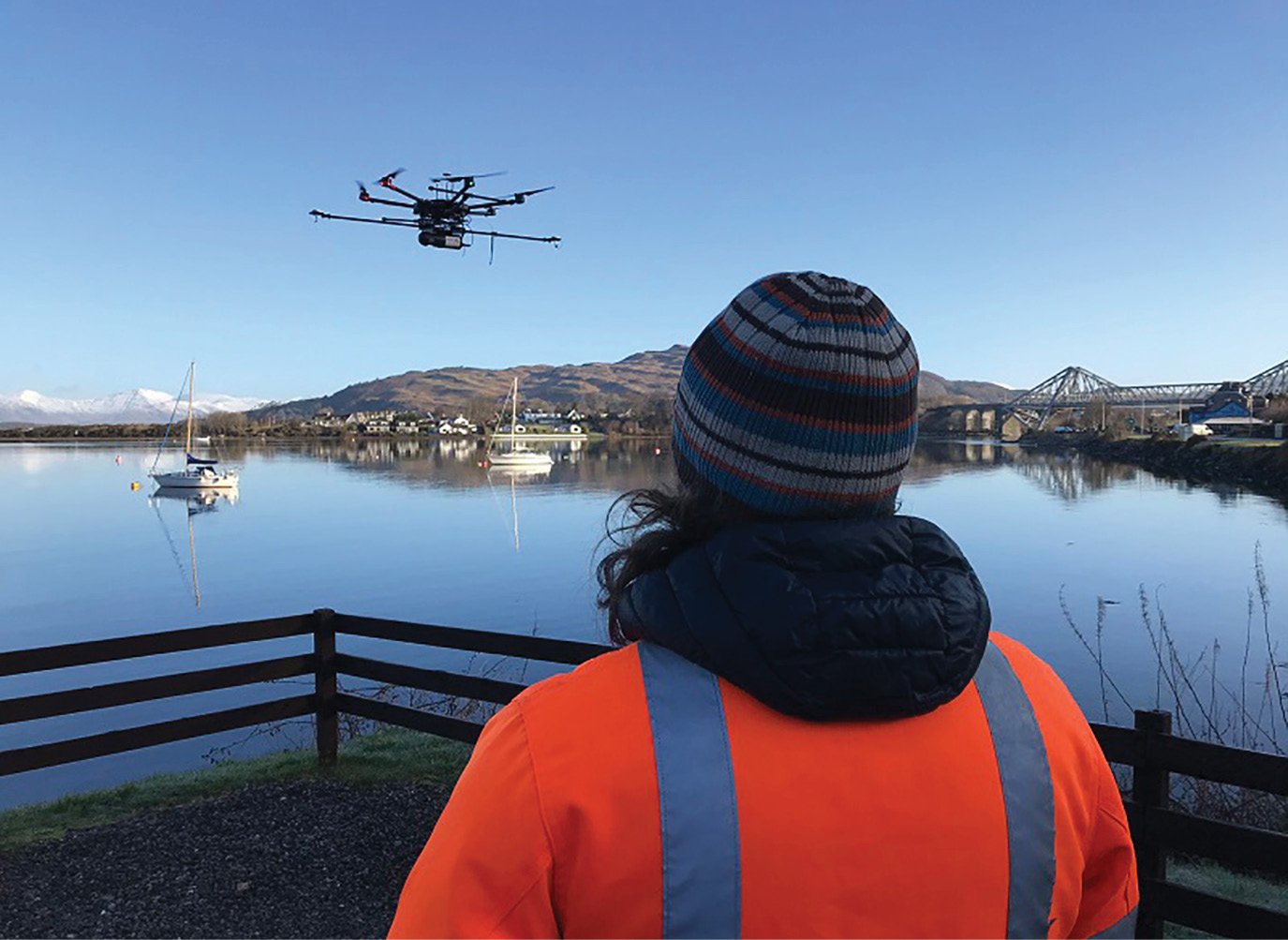
Mid-survey near Oban, Scotland.
Routescene’s Marketing Manager, Jason Rogers, interviewed Michael May and Ben Bishop from FlyThru1, a Routescene2 customer, whilst on location surveying a proposed cycle route between Connel and Dunbeg in the Scottish Highlands. On a cold and beautiful morning in March 2020 (prior to the coronavirus lockdown), we discussed how their business had benefited from UAV-lidar by investing
in a Routescene UAV-lidar system.
Editor’s note: A PDF of this article as it appeared in the magazine is available HERE.
Routescene: How did FlyThru start?
FlyThru: Flythru was started six years ago by two directors. I (Michael) brought business acumen and experience flying light aircraft and helicopters. My business partner Ben had flown and manufactured both fixed-wing and multi-rotor drones for a number of years. We met at a Civil Aviation Authority training course, hit it off immediately and realised we were better operating together than separately. So we built the business up from there. The focus of FlyThru, based in the UK, is the provision of UAV services to obtain aerial data.
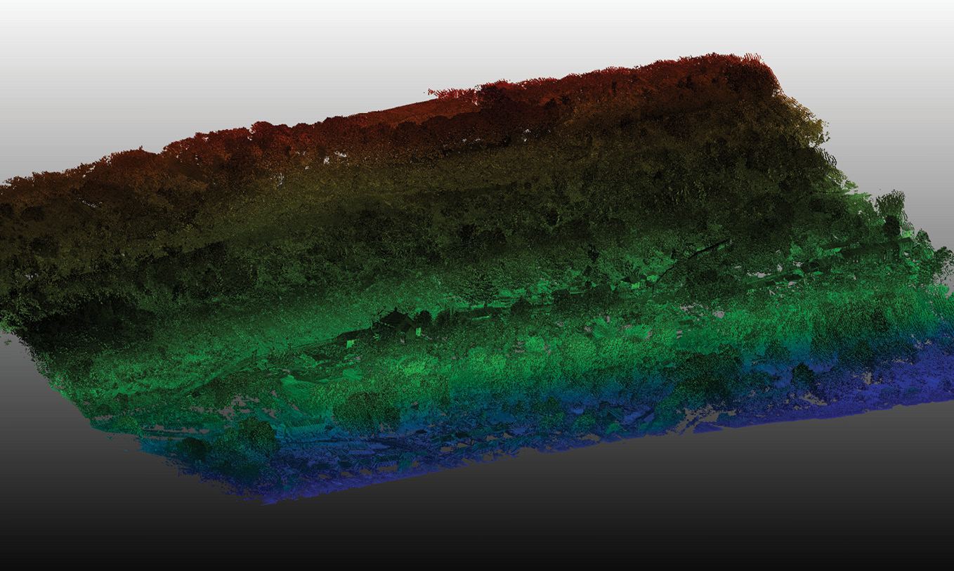
Point cloud displaying the dense vegetation coverage at the landslide site at Ystalyfera, Wales.
Airborne lidar has been accepted by the surveying community for more than a decade. With the emergence of UAVs, the possibility of acquiring aerial data in a more accessible way was an exciting one. Drones have the ability to fly much lower and slower than a helicopter or plane, with the benefit that the resultant point-cloud data has vastly greater detail. We saw UAV-lidar as a growing business opportunity.
Routescene: What technology did you use before you started working with lidar?
FlyThru: Most of our projects used UAV-photogrammetry. However this is unable to provide accurate ground data on sites where there is vegetation. The camera photographs the first thing that it sees, which is the tree canopy, so you are unable to create an elevation model that shows the floor of a wooded or vegetated area. The real magic of lidar is the ability to penetrate through vegetation to reach the ground, capture the ground surface accurately and produce a valuable Digital Elevation Model (DEM).
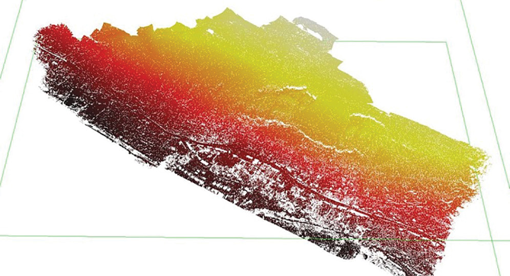
DEM at Ystalyfera, Wales to help identify the rate and scale of ground movement across the landslide area.
Routescene: How did you discover UAV-lidar?
FlyThru: We discovered UAV-lidar by accident really. We were working on a forensic archaeology instruction and the customer was using the Environment Agency’s airborne lidar equipment to help create site maps. The aim of the project was to find a clandestine burial site and lidar was perfect for this. We searched ‘UAV-lidar’ online and up popped “Routescene”, which provided such systems. We immediately jumped on a plane to Edinburgh in Scotland for a meeting to learn more. It all went from there and the rest is history.
Routescene: For you, in which applications does UAV-lidar stand out?
FlyThru: Nine times out of ten the purpose of our UAV-lidar projects is to produce a DEM. Typically we are working in locations where that is difficult or impossible to achieve using traditional survey methods and airborne lidar from fixed-wing aircraft or helicopters is cost-prohibitive. This is where UAV-lidar comes into its own—it’s much cheaper, easier and quicker to deploy.
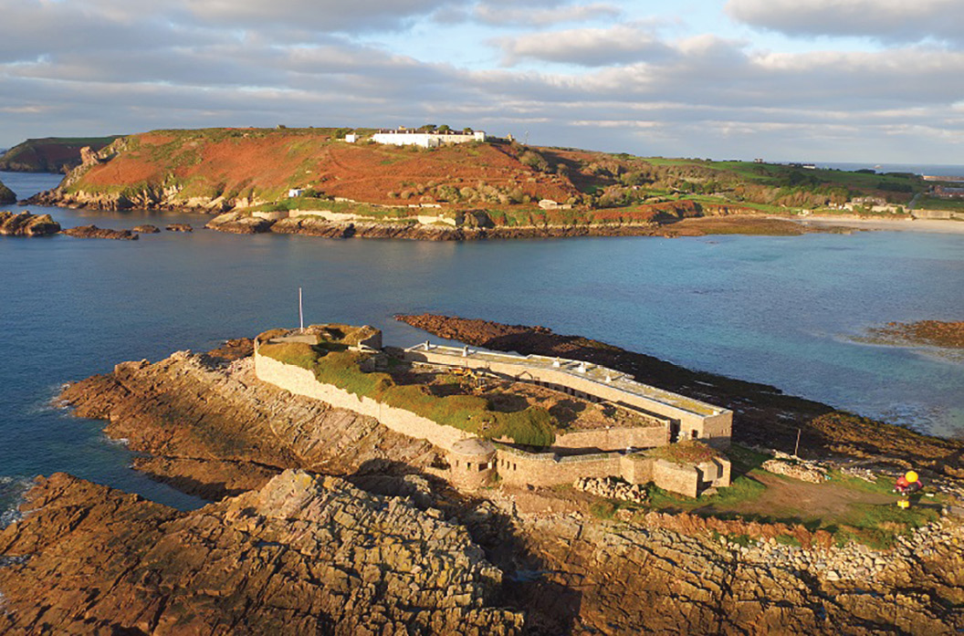
Alderney in the Channel Islands, UK—site of a UAV-lidar survey to visualise a WWII German concentration camp.
We have used UAV-lidar across a wide array of instructions from monitoring the habitats of beavers in the Scottish Highlands, to assisting planners assessing heavily vegetated areas for development, to investigating clandestine burials and other forensic cases.
Routescene: Who are your customers?
FlyThru: Our clients vary from planning consultants who want to assess sites for potential development, to forensic archaeologists, to landscape maintenance and preservation such as Scottish Natural Heritage. We use UAV-lidar because our clients are asking for it—they want to see quality, accurate data, which is impossible to achieve any other way.
Routescene: What obstacles did you face when first working with UAV-lidar?
DEM of the site of the concentration camp which uncovered new gravesites.
FlyThru: It’s been a learning curve. It’s easier to work with photogrammetry as everyone’s used to identifying objects in photographs. Interpreting what you see in a 3D point cloud is very different. When we first started we used to view a point cloud alongside a photograph so we could identify the features and objects easily. With help from the Routescene team we managed very quickly to get up to speed. We have the experience now to “see in 3D” and have learned how to interpret what we are viewing in the point cloud.
Routescene: What are you currently working on?
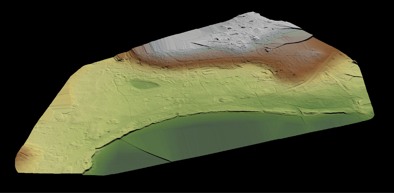
FlyThru: We are assisting a Council in the Scottish Highlands on a proposed cycle route between Connel and Dunbeg. The proposed route is covered by heavy vegetation, some parts cross over water and some are at the shoreline. It would have taken weeks to survey conventionally, some parts being almost impossible to access. So we used the Routescene system to undertake a complete survey in a handful of drone flights. The Council will use the final DEM output to assess the best course for the new cycle route.
Routescene: What are your most memorable projects?
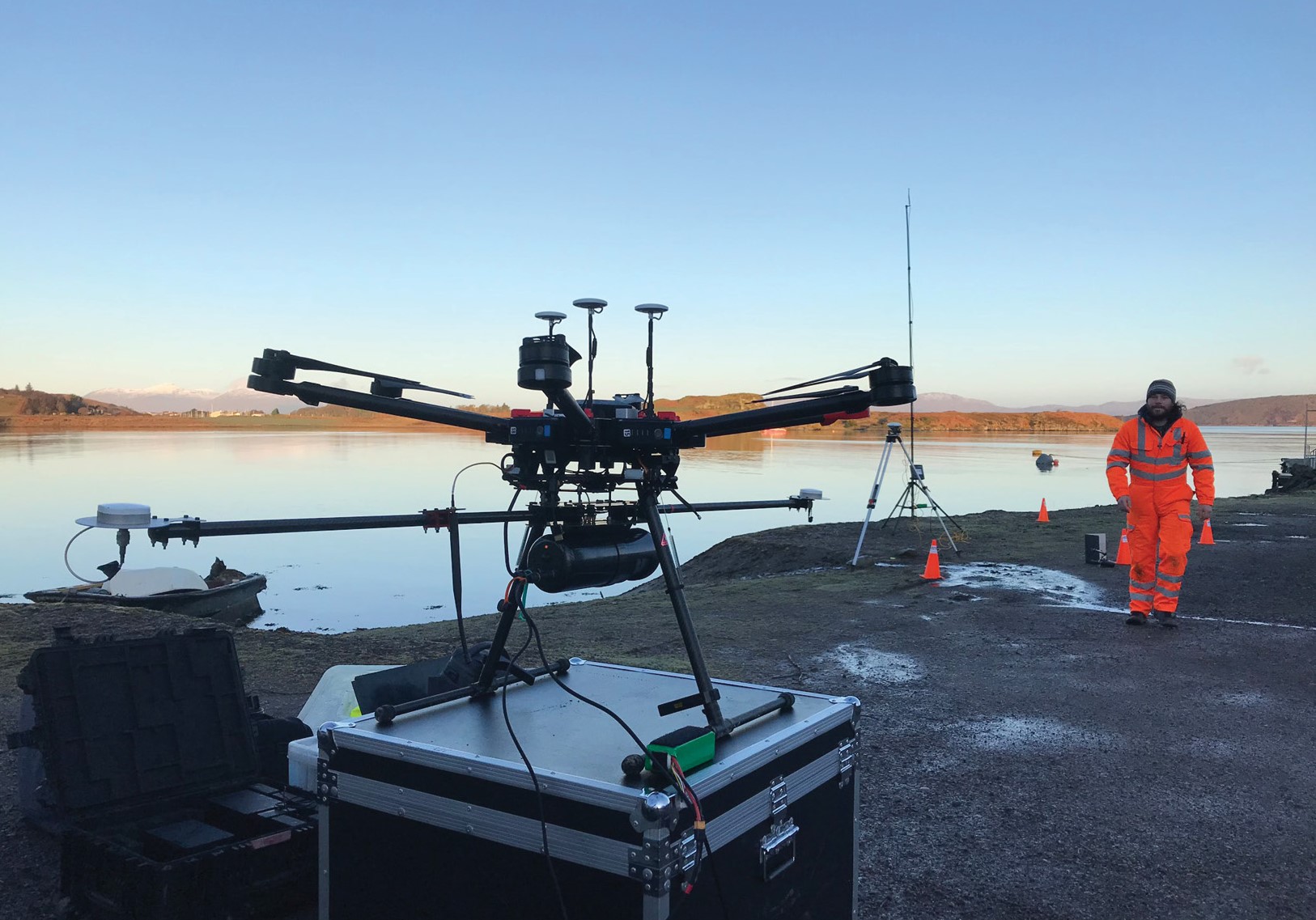
Full equipment set-up ready for survey of proposed cycle route near Oban, Scotland.
FlyThru: A repeat survey undertaken at frequent intervals of a landslip in Ystalyfera in Wales is certainly memorable. The aim was to identify the rate and scale of ground movement across the landslide area. Local residents were moved from properties that were at risk from future landslips. We believe this critical data led to peoples’ lives being saved.
A very different and equally dramatic project was to visualise a Second World War German SS concentration camp on the Island of Alderney in the Channel Islands, UK, the only camp on British soil. Combining the UAV-lidar data with photogrammetry and radar enabled us to capture unique data never seen before, which led the archaeologists to uncover new gravesites at the camp. It was a poignant project whilst thoroughly interesting at the same time. It was a great feeling to capture such powerful information for future generations to ensure it is never forgotten.
Routescene: How do you go about setting expectations with your clients?
FlyThru: The two key points to discuss are accuracy and the quantity of data they will receive. Often the clients think they want the highest resolution imagery and point cloud you can give them. But they don’t understand how much data the lidar system actually collects—millions upon millions of points! On a couple of instructions the clients simply didn’t have a powerful enough PC to open the data file—there’s that much information. We have to manage that expectation at the outset.
Typically we offer clients a DEM with a 25 cm grid resolution. In terms of accuracy we achieve <45mm in almost all projects. Again, setting that expectation is important—inaccuracies are obviously caused by the UAV in motion. It cannot be compared to a static terrestrial laser scan from a fixed ground point.
Through light vegetation we often achieve an impressive 400 points per square meter (ppsm), which compares very favourably against the 3,4,5 ppsm from airborne lidar.
Routescene: Talk us through how you tackle a new UAV survey project.
FlyThru: Safety always comes first and we consider, “Can we fly the site safely?” If the answer is yes, then we move to pre-survey preparation. Typically, we run an internet search looking at maps available online and use that information to produce an initial flight plan. A site visit, either beforehand or on the day of the survey, enables us to modify flight plans and routes, depending on what we find on site. Establishing ground control points (GCPs) is essential. We use the Routescene Ground Station, part of its UAV-lidar system, to survey in known co-ordinates to sub-centimeter accuracy. The Ground Station ensures RTK corrections are transmitted to the LidarPod and quality assurance and status information is transmitted to QA Monitor, the real-time in-flight data monitoring software. With GCPs established we can relate the data and the resulting model to the real world.
We then start to set up the equipment ready for the survey itself. First, we intialize the UAV and the Ground Station, then we place the GNSS antenna over one of the known GCPs to provide the reference for the RTK positioning. Next, we assemble the LidarPod and mount it underneath the UAV. We power everything up and perform a series of checks to ensure everything is functioning as it should. We are then ready to fly and collect data. During the flight we constantly review the data using QA Monitor, so we have the confidence we are collecting the required data. At the end of the mission we download the data into LidarViewer to check it there and then on-site, with this quick preview we can be assured it looks correct before we leave the site.
LidarViewer is a really good post-processing software package. It enables us very quickly to thin out the unnecessary data, remove any noise and within a matter of minutes we have a “tidy” point cloud ready for further processing.
Routescene: What would you say to someone thinking of using UAV-lidar in their business?
FlyThru: Having a good understanding of how the whole system works is vital to ensure you get the best from the system. One of the most important factors is being able to deal with the data processing. The LidarPod makes it easy to capture data, turning that into a useful product for the client is the challenge. Ensuring you have GIS/lidar data analytical skills is key, so you can turn a raw point cloud into a final output such as a 1m resolution gridded DEM. LidarViewer helps to make post-processing of such large volumes of data easier.
UAV-lidar adds another dimension to our drone service business. We can fly over and accurately map areas that are either almost impossible to reach or dangerous to walk through, such as landslips. It enables us to achieve accurate DEMs that would be unachievable otherwise.
Our UAV-lidar system is now used 2-3 times a week. It is in almost constant use The surveying world has accepted UAV-lidar and its outputs and we are receiving more and more instructions.
Routescene: How do you find the Routescene UAV-lidar system?
FlyThru: The LidarPod has been great for us because of its powerful vegetation penetration capability. 90% of the work we receive requires data to be acquired in difficult-to-reach, heavily vegetated areas. We were surprised by the high ppsm numbers we were achieving through dense vegetation, not just in winter, but in summer. Providing clients with high resolution DEMs as a result of achieving 400-500 ppsm, when previously they had had to work with DEMs derived from point clouds offering only 2-3 ppsm, has allowed us to develop our business with those clients.
Routescene: How have you found working with Routescene?
FlyThru: The advantage of working with Routescene over the last 3+ years was that both we and they were new and upcoming businesses which complemented each other. Routescene have been fantastic throughout this journey. If we have problems in the field they have helped us immediately on the phone. Usually that has solved the problems. If we do have any hardware or software problems we have been in direct contact with them and they have fixed it as quickly as possible.
Routescene: What difference has the Routescene UAV-lidar system made to your business?
FlyThru: Lidar has given us another string to our bow. We started with photogrammetry along with photographic imaging from drones. UAV-lidar is another mapping technique that complements photogrammetry and in some cases actually replaces it. It has probably grown our business by 50%.
The Routescene UAV-lidar system has been phenomenal. It’s really opened up a unique revenue stream for us. It’s enabled us to capture data that’s impossible to capture in any other way. That’s opened up doors with unique clients and also unique applications, which sets us apart from the rest of the field.