Lidar is a major source of geographic information, yet its voluminous data sets and their characteristics, which are different from those of image or vector data, historically have made it less accessible to GIS users. Esri and RIEGL are working together to improve the situation, helped by Ron Behrendt, managing director of Behron LLC, a geospatial consultancy based in Whitefish, Montana. LIDAR Magazine asked Ron to say more about his work.
LIDAR Mag: We’d like to discuss your work for RIEGL and Esri. Please tell us how this began.
Ron Behrendt (RB): I focus on providing clients who wish to utilize remote sensing technologies (imagery, lidar, radar, etc.) as information sources managed and analyzed in a GIS. I provided consulting services to Esri from 2011 to 2016, assisting with its new ArcGIS lidar capabilities and working with Esri’s users to help them better understand and benefit from this new functionality. During this effort, it became apparent that an improved customer interface between lidar sensors and the ArcGIS Platform would provide numerous benefits to the end user, including higher efficiencies, better data management, and the ability to leverage Esri’s new 3D Web GIS capabilities. RIEGL was quick to see the potential benefits for its customer base and in 2017 brought me in to help evaluate the opportunity to integrate lidar sensors more closely with GIS, explore technical options, and help develop prototype workflows that could be used for market research.
LM: Please tell us about the software you are developing and the difference it will make to users of RIEGL sensors and/or Esri software.
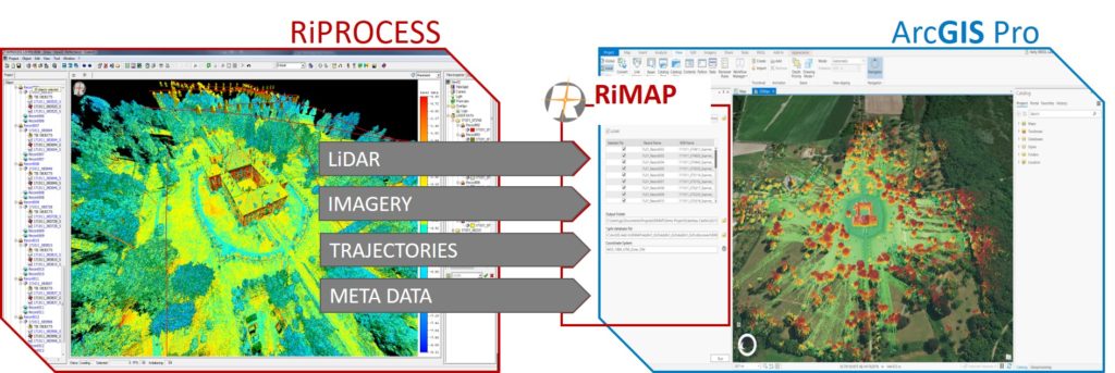
RB: RIEGL is currently developing the RiMAP software product, which is designed to smoothly transfer the content of a RIEGL scan project to Esri’s ArcGIS Pro so the data can be fully utilized for both desktop and web GIS applications. The beauty of this is that most of these projects have lidar and imagery. In terms of point clouds, the RIEGL RDB (RIEGL Data Base) data, which is created and populated as a result of performing post-capture processing with RIEGL’s RiPROCESS software, is brought into ArcGIS Pro for immediate analytics. Co-registered Imagery is made available as mosaic datasets or the new oriented imagery type as well as trajectories and some valuable metadata. One of the benefits of RiMAP and its data capabilities is that it has created the ability to leverage all ArcGIS functionality for storing and managing the data, a task which has become increasingly important as users are capturing more and more lidar including airborne (manned and unmanned) and mobile.
LM: What stage has the software reached? Is it ready to be launched, or in alpha or beta?
RB: The RiMAP software is currently in development with internal testing scheduled to begin Q1 2020. An extensive beta test program will follow, allowing the software to be well exercised before it is released to the general public, with the end goal of a high-quality offering that is simple to use. There is no firm date for the first release of RiMAP, but an announcement will be made when it is available for public use.
LM: How will the new software be monetized?
RB: RIEGL, with its strategic and long-standing partnership with Esri, will utilize the Esri Marketplace to distribute the RiMAP software. Created as an add-in to ArcGIS Pro, RIEGL’s RiMAP software will expand ArcGIS Pro’s capabilities and enable the functionality mentioned above. The first release of RiMAP will be targeted to owners and operators of RIEGL lidar systems and initially will be offered to them at no cost.
LM: What is the next stage in the process?
RB: We are exploring additional opportunities to expand the initial RiMAP offering and planning to announce RiMAP 2.0 during the second half of 2020. The architecture we are developing creates numerous opportunities to leverage many of Esri’s newest 3D technologies in combination with the highly accurate data captured by RIEGL lidar systems. We envision that RiMAP will grow and become an integral part of the workflow for professionals using the combination of RIEGL lidar and Esri ArcGIS.