 28 January, 2020, Bologna Italy – SITECO Infomatica SRL together with Sina, wins the tender awarded by ACaMIR.
At the end of the year 2019, the Campania Region Agency for the Mobility of Network Infrastructures (ACaMIR) awarded the tender for the “Supply of the Road Inventory of the regional road network, and the training, assistance and maintenance services under warranty”, to the joint venture led by Siteco Informatica and Sina.
The purpose of the proposed service consists of the detection, location, and inventory of all the roadside assets of the regional network (carriageway width and slope, intersections, road signs, entrances, infrastructure works, and so on) for an extension of 1500 km. All necessary information will be available for the creation of the Road Inventory under the Ministerial Decree 01.06.2001, and the realization of a road information system, in the GIS environment, allowing the navigation and management of database and geodatabase.
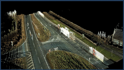
A step of great importance in the execution of the project is the analysis of the status of the road pavement of the regional network, which will be carried out through the automatic processing of point clouds, surveyed with the mobile mapping system (laser scanner and Ladybug camera). The International Roughness Index (IRI) and the road surface deformation status will allow the Contracting Authority to conduct analyses and make a decision about the intervention priorities.
Many improvements will be additionally introduced to ensure a high-quality service. A shortlist follows:
– High accuracy data supply, in terms of tolerances, coordinate acquisition frequencies and resolution of frames and videos.
– Marker survey along the entire road network, through the GPS signal. This activity will allow the detection of entities not recognizable in the imagery surveyed with the mobile system (e.g. underpasses, retaining walls, hydraulic works and in general any relevant works below the road surface).
– Automatic filters to eliminate “noise”, and classification of point clouds in the required classes (using proprietary deep-learning algorithms). Relating rendering with different color ramps.
In terms of software, the Road-SIT WEB application will be provided, perfectly integrated with the ArcGIS PRO system already adopted by ACAMIR for the management of their Geographic Information System.
In terms of software, the Road-SIT WEB application will be provided, perfectly integrated with the ArcGIS PRO system already adopted by ACAMIR for the management of their Geographic Information System.
Road-SIT WEB allows you to manage and consult the geodatabase, and access the information surveyed with the powerful Laser Mobile Mapping adopted: trajectories, point clouds and spherical images taken with the 30-Mpx resolution Ladybug 5 camera.
Road-SIT WEB also includes vertical modules for the management of specific roadside assets:
- Signs, the module for the management of technical and administrative data; a large set of functions for searching and updating data, the production of graphical and alphanumeric control reports.
- Licensing, the module for the ordinary management of all concessions and the payment of the relative taxes, production of reports or other specific documents. This module is already in use by many local authorities. The complete integration of the module with Road-SIT WEB allows access to the entire database, besides the road maps also cartography and videos. User access is managed according to customizable hierarchical levels.
- Inci-WEB, Integrated Traffic Accident Survey System, covering the entire cycle of information on accidents, from mobile surveying to the information exchange with the National Institute of Statistics (ISTAT), the various traffic police bodies and the Local Authorities, and the data validation for checking the correct location. The system can be used both in statistical mode (by users involved in accident monitoring) and during the mobile survey (by the local police bodies).
- Road-SIT PMS, (Pavement Management System), integrated into the ESRI ArcGIS platform, it allows consultation and monitoring of the maintenance status of the road pavements, and maintenance activity management.
The General Director of Siteco Informatica, Ing. Augusto Burchi, stated: “Our software applications have been a winning point in the offer presented. The features cover all the important issues of the public administrations and this is a reason for satisfaction. However, our commitment is to continue the research and development of more and more innovative features.”
About Siteco Informatica s.rl
A unit of the Gavio Group, A unit of the Gavio Group, one of Italy’s top industrial groups. Siteco was established in 1995 as a civil engineering infrastructure, software and technical consulting firm. In 2005 they developed the first scalable, high performance fully integrated mobile mapping system and have since been delivering the most flexible roadway management mobile mappers in price, performance and software flexibility on the market. Siteco’s Road-Scanner hardware and software products are fully compatible with Faro, Z+F, Leica, Riegl, Teledyne Optech, Topcon, Teledyne and other mobile mapping systems and sensors.
