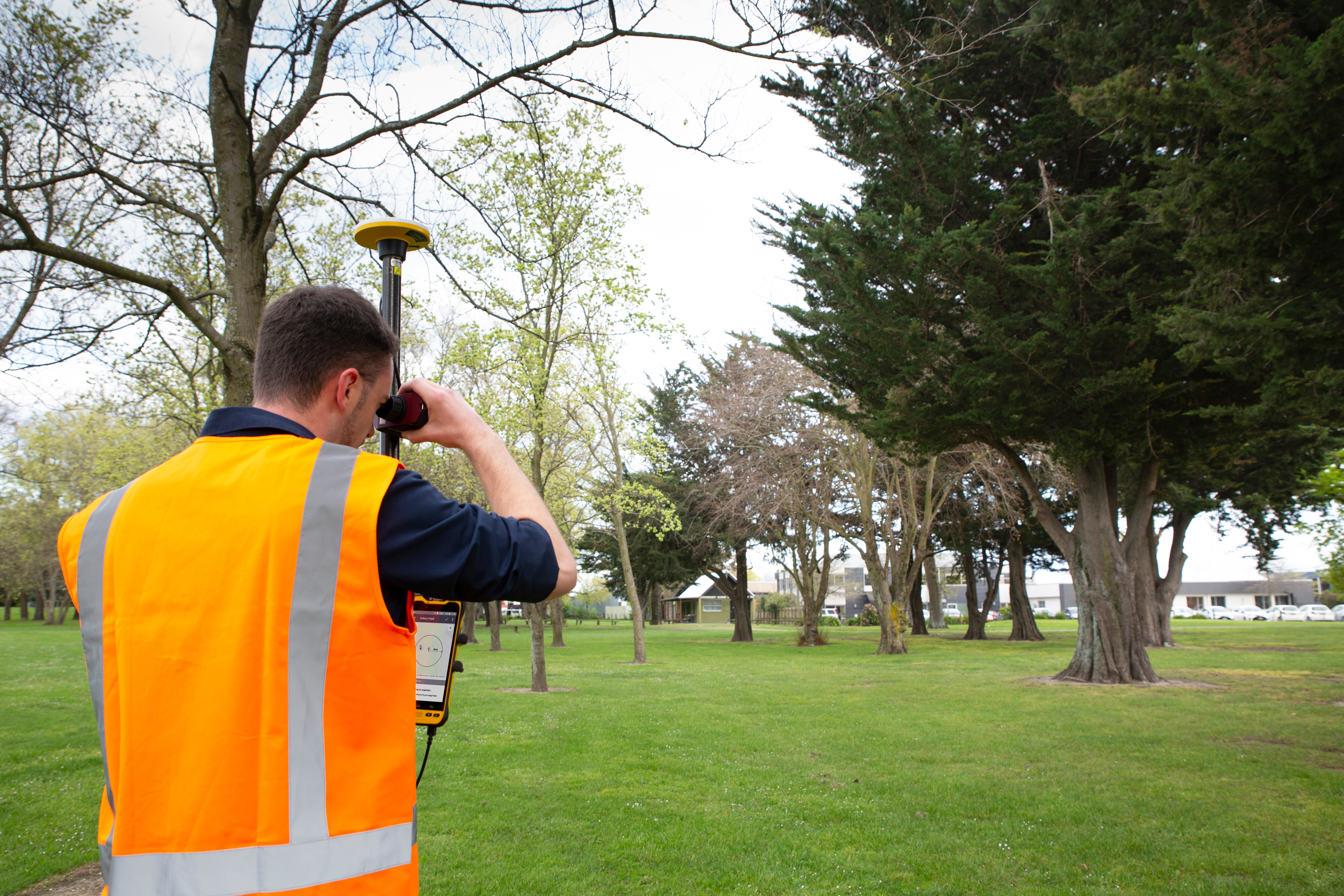
 Sunnyvale, Calif., Dec. 11, 2019—Trimble (NASDAQ: TRMB) announced today its Trimble® TerraFlex™ field software now supports remote feature capture with Laser Technology, Inc. (LTI) TruPulse® 200 series and 360° series laser rangefinders. The solution enables easy, accurate and safe capture of Geographic Information System (GIS) features in locations that are physically inaccessible, hazardous and in challenging Global Navigation Satellite System (GNSS) environments.
“Assets in places such as a busy roadway or under dense tree canopy can make it difficult for users to capture location information accurately, safely and efficiently,” said Derrick Reish, senior product manager at LTI. “The TruPulse series laser rangefinders enable users to accurately measure these assets without having to physically occupy the location.”
 The new TerraFlex feature extends the reach of Trimble GNSS solutions when paired with the TruPulse laser rangefinders. These include the Trimble TDC150 high-accuracy GNSS handheld or the Trimble TDC600 handheld running the Trimble Catalyst™ on demand positioning service.
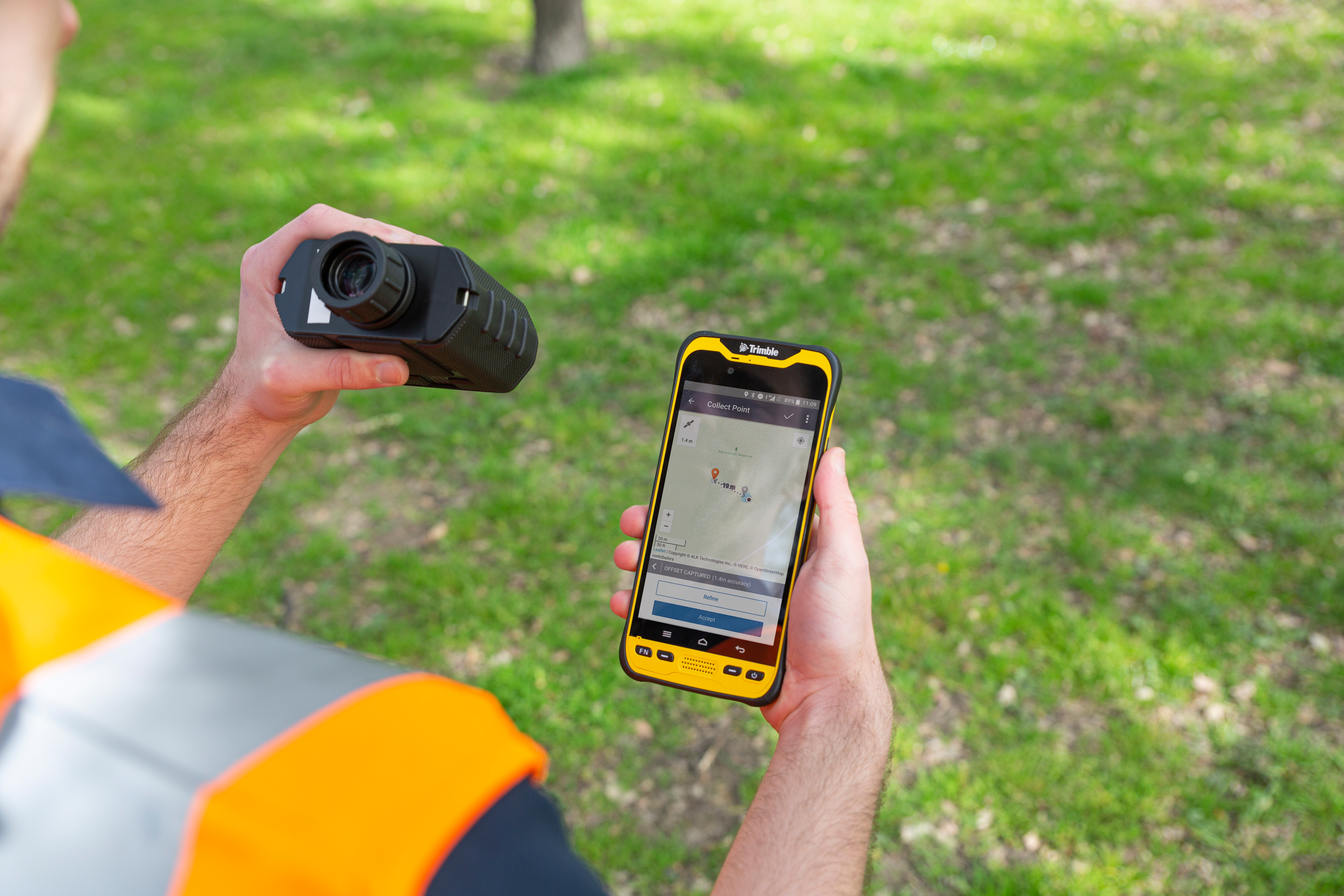
“Embedding this functionality directly into the TerraFlex app simplifies the offset mapping workflow and enables users to accurately capture features in more places,” said Rachel Blair Winkler, business area manager for Trimble Mapping & GIS Solutions. “This release represents the continuation of Trimble and LTI working together to support laser rangefinder technology in Trimble GIS software solutions.”
Availability
Trimble TerraFlex is available online at geospatial.trimble.com/terraflex or through Trimble’s Authorized Geospatial Distribution channel. LTI TruPulse 200 series and 360 series laser rangefinders are available through LTI’s authorized dealer channel. For more information, visit: www.lasertech.com/TruPulse-Laser-Rangefinder.
About Laser Technology, Inc.
Laser Technology Inc. is a Colorado-based manufacturer devoted to the design and manufacture of innovative laser-based speed and distance measurement instruments to address real-world needs and applications, including speed enforcement, accident investigation, forestry, mining, utilities and surveying. Visit www.lasertech.com for additional information.
About Trimble Geospatial
Trimble Geospatial provides solutions that facilitate high-quality, productive workflows and information exchange, driving value for a global and diverse customer base of surveyors, engineering and GIS service companies, governments, utilities and transportation authorities. Trimble’s innovative technologies include integrated sensors, field applications, real-time communications and office software for processing, modeling and data analytics. Using Trimble solutions, organizations can capture the most accurate spatial data and transform it into intelligence to deliver increased productivity and improved decision-making. Whether enabling more efficient use of natural resources or enhancing the performance and lifecycle of civil infrastructure, timely and reliable geospatial information is at the core of Trimble’s solutions to transform the way work is done. For more information, visit: geospatial.trimble.com.
About Trimble
Trimble is transforming the way the quality, safety and sustainability. From purpose built products to enterprise lifecycle solutions, Trimble software, hardware and services are transforming industries such as agriculture, construction, geospatial and transportation and logistics. For more information about Trimble (NASDAQ:TRMB), visit: www.trimble.com.
