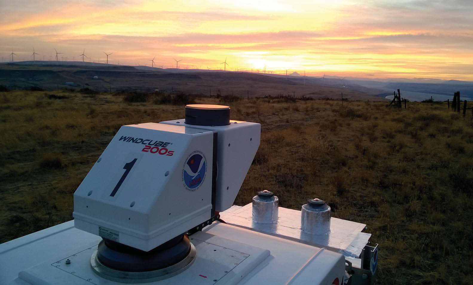
Leosphere Windcube Scanning Lidar measures wind for development and operations applications. Photo courtesy NOAA
We’re all aware that lidar (light detection and ranging) data supports a myriad of surveying activities—from modeling and mapping to emergency response and vulnerability analysis—but not as many people know that lidar technology allows us to understand weather in a way that hasn’t been done before.
Much like in surveying and mapping applications, lidar is a remote sensing method that uses pulsed laser light. Rather than being pointed at a targeted area on the ground to measure a range, in weather applications, short pulses of laser light are shot into the atmosphere to measure atmospheric constituents, such as aerosols, pollutants and other particles—and their dynamics. When light is reflected off of these components, it’s backscattered into an opto-electronic detector, and the return pulses reveal a profile of these atmospheric elements and the corresponding distance between those elements and the lidar device. Analyzing this information yields information about the variable distances and distribution of molecules and particles in the atmosphere.
Necessary for myriad applications, from climate modeling and land surveying to weather forecasting and more, the data lidar systems reveal is incredibly useful across the meteorology, aviation and wind energy sectors.
Meteorology
Weather can be difficult to predict. But weather forecasting is extremely important for all economic activities impacted by atmospheric conditions and pollution at a certain place and time, including blistering heat, fog, haze, smog, heavy wind, rain, snow and other critical events.
Most natural disasters stem from severe weather phenomena, including thunderstorms, hurricanes, hailstorms, tornadoes, heavy precipitation, flooding and damaging winds. Worst of all, these disasters often lead to human casualties and property damage. Detecting and forecasting hazardous meteorological events allows decision-makers to warn citizens and execute timely emergency response and rescue operations. From maritime ports and airports to industrial sites and leisure activities, monitoring and forecasting meteorological threats is incredibly important.
Windcube Scanning Lidar. Photo courtesy NEA
Where weather is concerned, the next generation of high-resolution weather prediction models will require a very high level of spatial and temporal continuity that only a combination of technologies can offer. Existing observation networks need to be complemented with denser and more local networks for better understanding, monitoring and forecasting of severe weather.
Used to investigate and analyze atmospheric properties from the ground up to the limits of the lower atmosphere, lidar sensors fill the gap between the ground and what satellites can observe from space. Satellites struggle to provide data below clouds and close to the ground. Met agencies need an accurate complement to satellite data and numerical weather forecasting models to identify, locate, characterize and quantify atmospheric constituents and dynamics from near-ground levels all the way to the top of the troposphere. Lidar helps with visualizing what’s “invisible,” aiding atmospheric researchers and climatologists trying to model the complexity with a better understanding of our atmosphere.
Measuring aerosols, temperature, pressure and humidity using networks of remote sensors feeds climate models and databases with continuous profiles of the optical properties of the aerosols and meteorological constituents in the atmosphere. Using mathematical models of the atmosphere and oceans, advances in numerical weather prediction (NWP) represent a quiet revolution because they have resulted from a steady accumulation of scientific knowledge and technological advances over many years. A number of forecast models use weather observations relayed from lidar sensors as inputs. These lidar networks help met agencies monitor the meteorological impact, greatly improving short- and long-term weather forecasts. Already being used in New York state to improve the detection and prediction of severe weather events, 17 lidar units have been integrated into enhanced weather stations dispersed throughout the state to provide real-time observations.
Aerosols accelerate the melting of glaciers by darkening their surface, they damage electrical and transport infrastructure, and when combined with local pollution, they also worsen air quality. Poor air quality is the most serious environmental health issue globally and the primary driving force for ambient air quality monitoring. When it comes to air quality, lidar has two applications: monitoring of emissions and forecasting of air quality. Mapping the distribution of aerosols in complex urban environments allows air quality operating agencies to tackle exposure challenges, identify source hotspots or manage the positioning of air quality stations. The ultimate goal of doppler lidar technology is not only to describe and understand the physical and chemical processes, but to drive urban development strategies and better forecast air quality and meteorology at large urban sites as well.
From an observational perspective, meteorological data has historically been measured using radiosondes twice a day, and that remains the most common practice in obtaining current weather data. The main advantage of remote sensing lidar instruments to complement radiosondes is the potential offered by nearly continuous monitoring. Meteorological forecasting and nowcasting mainly improves with more frequent observation.
It’s crucial that meteorological agencies continuously monitor all meteorological and atmospheric parameters, including wind, turbulence, clouds and aerosols, so they can contribute to efficient and effective crisis management assistance by public authorities and private companies. When it comes to the high-resolution data lidar instruments reveal, that information can help predict local severe weather and storm formation as well as generally improving weather forecasts, ultimately saving time and lives.
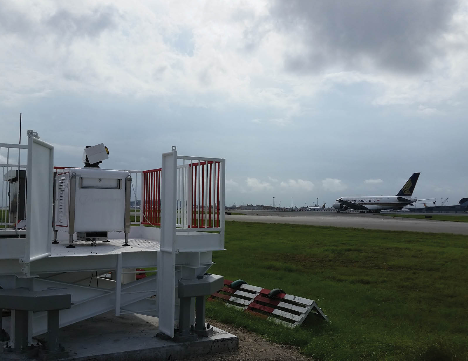
Scanning Lidar measuring wake turbulence at an airport. Courtesy of Leosphere
Aviation
As far as the aviation industry is concerned, lidar has two fields of application: safety and efficiency. Airports use lidar technology to gather real-time and highly accurate wind and aerosol measurements adapted to the airport environment, providing critical information that helps ensure safe takeoffs and landings and improves overall air traffic management (ATM) efficiency.
One of the major causes of accidents during takeoffs and landings, inclement weather is an unfortunate and costly reality for many airport hubs around the world. The primary concerns for pilots and air traffic controllers are weather and wind, but lidar solutions at airports are helping to mitigate wind-related hazards.
The number one threat in aviation weather, wind shear can be described as a sudden change in wind speed and/or direction that causes a plane to deviate from its intended flight path. The unpredictability of wind shear is responsible for the disruption of air traffic, significantly impacting airport operations. Wind shear involving changes in headwind or tailwind of 15 knots or more have been determined to be a serious danger that could adversely affect an aircraft’s lift and air traffic operations, per the International Civil Aviation Organization (ICAO). To that point, wind shear phenomena have caused more than 1,500 deaths in aviation since 1943.
Statistically the most dangerous flight phases, the final approach and initial take-off paths require a proper measurement and alerting system to determine the right moment to take off or if pilots need to avoid or be careful of specific events. Lidar technology is one of the best technologies for wind shear monitoring due to its ability to detect clear air wind shear events, which are invisible to pilots and air traffic controllers, over a 10-kilometer approach. Updated every minute, wind shear alert data from the lidar sensors can be embedded in the automatic weather observing system (AWOS) and displayed in the AWOS interface like any other meteorological information, automatically generating alerts for air traffic controllers.
Additionally, lidar can measure any wind or turbulence, improving the wind awareness around the airport. This information helps meteorological office forecasts to get a better understanding of wind conditions around airport and make further decisions surrounding safety.
As far as efficiency, lidar also measures wake turbulence generated by the wings of aircrafts. A major concern in air traffic management (ATM), measuring the wake turbulence allows for air traffic growth through improvement of runway throughput. Today, air traffic is regulated with minimum distance separations, which are sometimes considered as overconservative. A more comprehensive understanding of the wake turbulence characteristics enables ATM to apply new distance separations while removing the risks related to this phenomenon.
The only technology able to characterize wake turbulence in application today is wind lidar. In specific configurations, lidar sensors acquire wind data, and unique software computes the characteristics of the vortex turbulence, generating a database of the behavior of wake turbulence at a given airport. To safely reduce the minimum separation between a given pair of aircraft, whether on departure or on final approach, both the wake vortex generated by the leader and the following aircraft’s resistance to it have to be taken into consideration. Based on this information, ATM controllers can safely apply reduced distance between planes, ultimately improving runway throughput and airport capacity.

Windcube Scanning Lidar. Photo courtesy NEA
Wind Energy
Whether developing or operating a wind project, it’s important to understand what the wind is doing—and lidar helps do precisely that. Lidar measures the full wind regime and characteristics of the wind flow, including wind speed, wind direction and turbulence all the way up to 200-plus meters.
When it comes to producing wind energy, bigger turbines and more efficient wind farms are the name of the game. In fact, based on Electric Power Research Institute (EPRI) data, a 1% annual production increase at a typical wind farm with 100 two-megawatt turbines can increase revenue by up to $500,000 per year.
However, a significant amount of time and effort goes into developing a wind farm before the first turbine begins producing energy. Prospectors measure the wind’s behavior at a given location for at least one year before a development plan is approved—and accurate data is the primary variable in their bankable wind resource assessment. Consequently, inaccurate wind measurement can result in less favorable financing conditions, an incorrect investment decision or the wrong type of machinery being selected, which can lead to underperformance or failures.
Meteorological evaluation towers, often referred to as met towers, have traditionally been the primary technology to conduct wind measurement, but as turbine height grows beyond 150 meters tall, met towers are unable to deliver data at such height with reasonable costs and safety conditions. Lidar allows for accurate and more expansive measurements of the full wind profile in the prospecting phase, helping determine the wind turbines to be selected and how much wind energy a future wind farm would produce.
Permitting and installing met towers takes a significant amount of time before wind prospecting even begins. But developers that use lidar sensing not only shave weeks or months off their development phase, they are also empowered with the benefit of mobility. If they need to move the sensor for a more impactful measurement, they can do that safely in a matter of hours. There’s no permitting required or tower to build.
Additionally, lidar technology can be mounted on the wind turbine’s nacelle itself to scan in front of the turbine, measuring the wind that will hit the rotor. That way, wind farm owners can use it as a diagnosis tool to verify and optimize their assets, securing their revenue. It can also be installed permanently as a turbine component to improve the turbine reaction to the ever-changing wind conditions, leading to an increase in energy production—through better alignment to the wind—and turbine lifespan—by limiting the stress on key components such as gearbox, rotor or tower.
While the first commercial lidar products for these meteorological, aviation- and wind energy-related applications didn’t reach the market until the early 2000s, lidar technology matured very quickly. As lidar technology continues advancing, the revolutionary sensing technology will only find additional applications as it permeates new industries and continues to provide more accurate and more robust data. Lidar technology has already allowed us to understand weather in a way that hasn’t been done before, benefitting myriad industries—what’s next for the future of lidar?