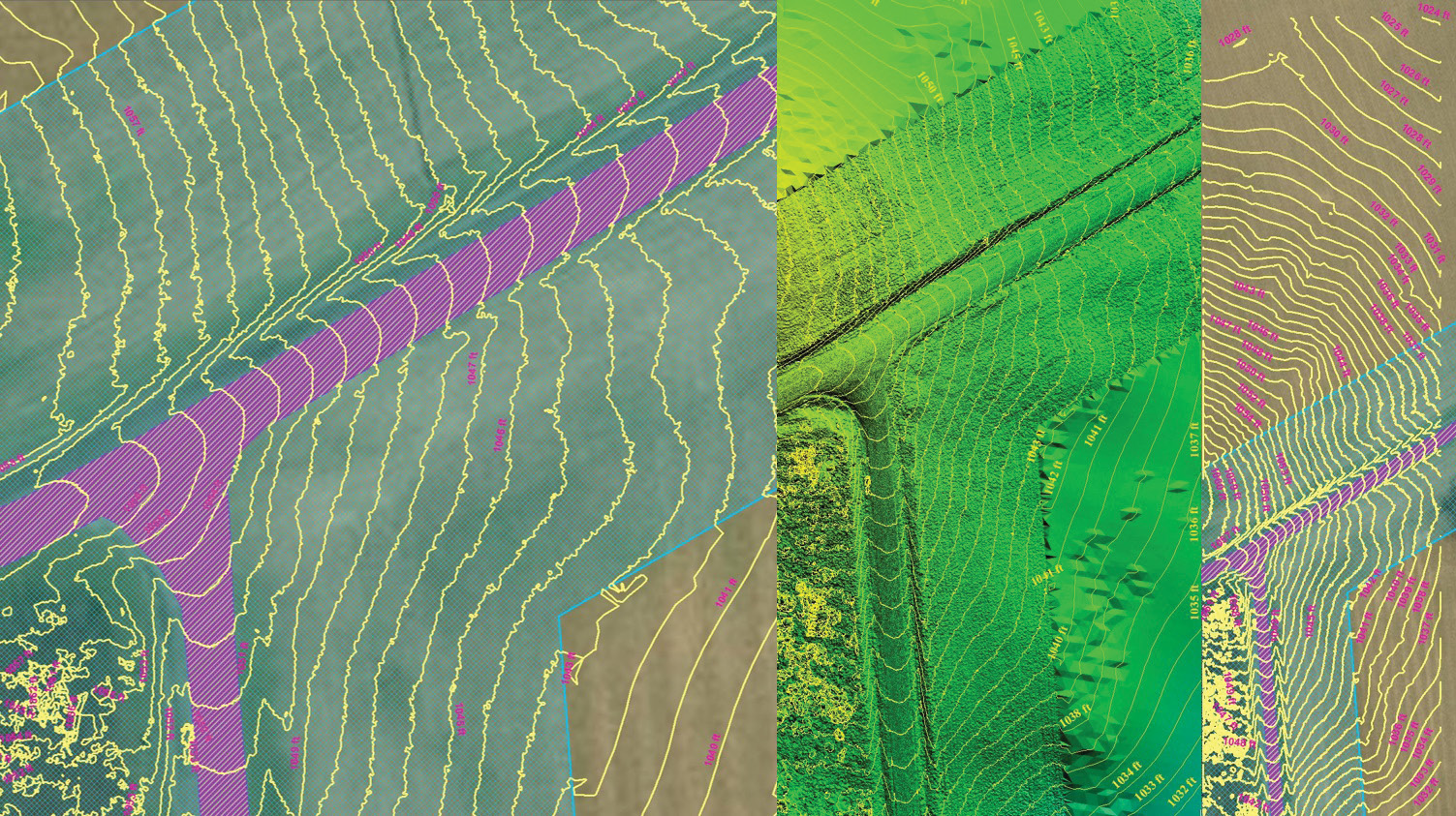
This image depicts seamless contour lines after three point clouds have been merged and a digital surface model has been generated. Courtesy of Woolpert
If you feel every business but yours has a drone, here’s why: the market for commercial drones is growing faster than even the Federal Aviation Administration (FAA) expected, it is now forecasting that sales will triple by 2023. In less than a decade, unmanned aircraft systems (UAS) are in line to create 100,000 jobs and add $82 billion to the U.S. economy. These statistics make the endeavor sound tempting, but at least one trailblazing UAS expert suggests you do some research before making that leap.
Aaron Lawrence, GISP, was instrumental in Woolpert—an international architecture, engineering and geospatial (AEG) firm—becoming the first surveying and mapping firm approved to fly UAS commercially in designated airspace in 2014, through the FAA’s Section 333 exemption. Lawrence also became one of the first people in the country to earn his Part 107 Remote Pilot Certificate in 2016 and continues to accrue UAS certifications specific to individual agencies and organizations—most recently for the Pennsylvania Department of Transportation.
For Woolpert, Lawrence performs projects and evaluates technologies for multiple commercial UAS applications, while fostering the firm’s growing fleet of pilots. In this Q&A, Lawrence discusses the rise of drones across the industry and shares how to best approach the commercial application of this technology to prevent wasting your firm’s time and money—and to prevent compromising the deliverable to your clients.
Q: You have been involved since the beginning of this technology. What has led to this UAS industry boom?
A: Everything’s going jet-engine and not many companies are making aircraft like the 1970s-era piston-powered Cessna that could fly low at 100 mph. This has made drones the logical next step for aerial photography. But, as with any professional equipment, don’t get one because it’s cool or because everyone else is doing it. Drones are just a new way to collect aerial information that happens to be unmanned. Yes, we can see 2.5 mm from 75 feet instead of 10 m pixels; and yes, we’re counting rivets on structures and bridges. The capabilities are truly awesome.
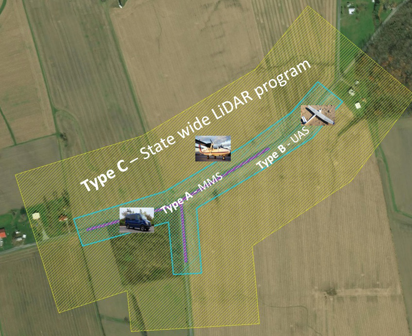
Coverage-area polygons in this image represent the data from three individual mapping tools: UAS, MMS and statewide lidar. Courtesy of Woolpert
But these systems generate huge files that must be processed and analyzed, creating the need for robust data-management software and new photogrammetric workflows. And, in many ways, the technology is still in its infancy. Manufacturers are refining cameras and lasers, and prices are dropping. But just one change in federal regulations—allowing beyond-line-of-sight (BLOS) flight, for example, or drones that weigh more than 55 pounds—could radically alter any organization’s program and investment.
Does that mean you shouldn’t buy one? Not at all. Just don’t expect it to solve all your problems and understand that it will create new challenges. Have realistic expectations: A drone is just one tool in your toolbox. We want our surveyors to have a drone, but we don’t expect drones to replace surveyors.
Q: How do you integrate drones successfully into your operations?
A: We approach every job by asking, “What’s the most efficient way to collect data that will meet this client’s accuracy requirements?” Using just a drone to collect this data is rarely the solution. What you want is to fuse data from multiple sources to get the most accurate picture of reality, so you can make the right design decisions.
Let’s take the Highland County Engineer’s Office Petersburg/Overman intersection improvement project, which is in Amish country. The point at which these roads converge is an elevated knob, creating a dead man’s curve. Drivers coming from the west would travel at high speeds but, due to the bend in the road, couldn’t see the buggies turning on to the road.
When the county asked us to investigate the site, our project manager Nathan Fischer took a best-of-breed approach. We had year-old lidar data from our (Ohio Department of Administrative Services) Office of Information Technology contract to map the entire state. That gave us 2-8 points per square meter (ppsm) for a 6-15-cm root mean square error(RMSE). That’s pretty good, but it doesn’t provide surface detail. We used our mobile mapping system (MMS), a van equipped with two Teledyne Optech lidar sensors, to collect data. Now we have 2000-6,000 ppsm for a 1.5-cm RMSE. Then we used a drone—40 to 1,000 ppsm for a 5-15-cm RMSE—to capture what the MMS couldn’t capture.
We combined the drone-generated data with the MMS data and the existing statewide lidar to generate a digital surface model (DSM), reflecting the best of breed in data extents, resolutions and accuracies. Ground control points (GCPs) were used to control and independently verify the accuracies of the data from these three sources. This is a good example of why you will always need surveyors and these GNSS inertial measurement units.
Q: If an organization is considering adding a drone program, what can it do to ensure success?
A: Two things: One is technical and the other safety-related. On the technical side, use the American Society for Photogrammetry and Remote Sensing (ASPRS) standards for digital orthoimagery, planimetric and elevation data released in 2014 to develop program specifications. Accuracy classes, based on RMSE values, were updated from the 1990 standard to reflect advances in technology since then.
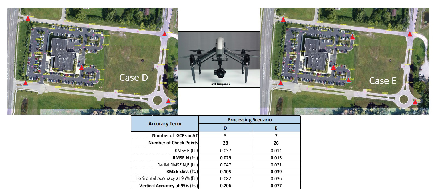
This is a comparison of two different GCP configurations at our Dayton, Ohio, calibration field and the accuracies achieved by each. Courtesy of Woolpert.
On the safety side, follow the U.S. Department of Transportation’s (DOT) Unmanned Aircraft Systems Integration Pilot Program launched in 2018. The agency is working with multiple state, local and tribal agencies—including the Kansas, North Carolina and North Dakota DOTs—on night operations, flights over non-participants and BLOS, package delivery, detect-and-avoid technologies, and data links between pilots and aircraft. The results may accelerate approval of operations that currently require special authorizations.
Q: How do you assess manufacturers’ claims regarding the capabilities of sensors or systems?
A: I automatically knock 20% off the stated flight time because, since they’re trying to sell that product, they state what the flight time would be in optimal conditions—sunny with no wind. You’re not going to be flying in optimal conditions. If it’s too hot or too cold, you’ll be sitting in the truck with the air conditioning or heat on.
I also take vendors’ accuracy claims with a grain of salt. Woolpert has a drone test site and calibration field at headquarters in Dayton, Ohio, where we verify all manufacturer claims using different GCP configurations. So, when a vendor says, “We can create a 1/10 vertical accuracy with no control,” we can say, “Come on over to our site and prove it.”
Q: Why are GCPs and the adherence to the standard they set so important?
A: GCPs can help us achieve the holy grail: accurate, repeatable results. We’re trying to figure out how many GCPs you need to achieve a specified accuracy. We’ve achieved 2-cm RMSE, but we haven’t quite made it repeatable yet. We’re not far off, though, and that’s where we’re focusing our efforts.
It’s this kind of research and development that has become our sweet spot with UAS. Woolpert used to be the ones flying the projects and collecting the data. We still do that, but we’ve also responded to the demand to share what we’ve learned over the years in the industry—in UAS, geospatial, survey, lidar, etc.—by helping organizations develop their own drone programs, so their pilots can fly and crunch the data. It’s similar to how our role evolved when the industry moved from CAD to GIS: We facilitated the transition by helping organizations manage the data.
By playing this role, we ensure the creation of better-quality data, which will then have expanded applications and lead to groundbreaking solutions. We do this to help this awesome and evolving industry continue to grow in the right direction. I love this medium and learning every day what UAS can do, and I want to make sure it’s done right.