For this installment of quick-takes, we caught up with Troy Hittle of senseFly USA, manufacturer of America’s most popular fixed-wing drone platform, to discuss the drone mapping marketplace.
Troy, we understand you started off in the USAF, owned your own drone firm at one point and are now the general manager (GM) for senseFly USA. Please tell us a little bit about how you came to be where you are.
My role in the Air Force as a TACP1 laid a natural path for me to get into drone work as a civilian contractor. Being a TACP helped me to understand the ground-to-air communications, while the drone piece helped me to understand the capability from air to ground.

Troy Hittle, general manager, senseFly USA
After years of serving in all roles in the drone space as a contractor, I wanted to be more involved in the beginning phases of the rapidly evolving commercial space. I saw no better way than to jump right in with an ag startup that was co-founded with two other veterans. My role was to source solutions for the grower and agronomist by working with different OEMs and educate those interested in drone technology.
I continued my ag focus and leapt at an opportunity with senseFly when they had an opening for an ag sales manager. As we grew our distribution, our team and further developed the US and Canadian markets, it was decided that a GM role was important to continue our efforts, become even stronger as the US hub and be tied in closely with our efforts as a global company.
You’ve spoken about working with industry pioneer Jeff Fagerman (LiDAR USA) early on. Since most of our readers are interested in lidar, can you speak briefly to this collaboration?
Yes, Jeff and I go way back to some of the work I was doing with the ag startup. We worked together on bringing that capability to agriculture. At the time, the startup was running its solution from a truck, but was on the verge of putting it on a drone, so I was able to help provide some insight. It’s safe to say, however, that Jeff figured it out – quickly. I think we both agree that there is no competition between photogrammetry and lidar, and my spin on that is that there’s the right tool for the right job.
Are you seeing significant interest in multispectral imagery from your customers (and if so, where)?– What is senseFly’s position on lidar?
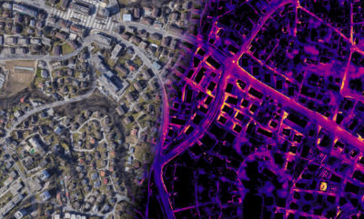
senseFly “Duet” thermal orthomosaic.
Yes, multispectral has been key for many customers on their journey of discovery, whether it be in the research setting — providing insights on what we cannot see with the naked eye — or in the commercial setting, for agronomists and growers to help make operational decisions, identifying patterns and using comparable data to better predict possible outcomes.
We are bound by our desire to make safe and easy-to-operate drones. With this comes some limitations on sensor technology. Lidar is an emerging technology, in many ways, for small UAVs, as we are still to reduce size and weight whilst also keeping good resolution. This is the challenge for lidar sensor providers. This is a space we will continue to watch as the sensors meet these expectations. Lidar is a valuable technology, there’s no questioning that. From an airframe standpoint, it’s important that we stay light. If lidar were small and light, then I can’t imagine not taking a serious look at it. There is plenty of work to do with both lidar and photogrammetry, although as we currently stand today, senseFly’s solutions are geared toward the latter.
In your opinion, where are we at today with regard to drone legislation? Has Part 107 “worked out the kinks” or is there much yet to be done?
If you look at the total body of work, then we’ve come a long way, starting with the industry being regulated back in 2016 with Part 107. In my opinion, we are headed in the right direction. I think most would like to see things move faster, which is a compliment to the technology in the shared understanding of the great potential to be leveraged with NAS2 integration and the significance of getting it right to make sure it’s done in the safest manner possible. We’ve seen positive outcomes and are working hard as a manufacturer to help ensure that further initiatives can be put in place. At the end of the day, yes, there’s still a lot of work to be done but with the latest BVLOS waivers and drone delivery there is light on the horizon.
Per 2018 FAA commercial drone figures, senseFly proclaims to be the United States’ most popular fixed-wing drone—why do you think that is? Also, can you speak to where the majority of this business comes from?
Primarily, it’s because we’ve been around for almost a decade, which has enabled us to become the industry standard for the lightweight fixed-wing drone mapper. Along the way, we’ve invested more by evolving our product to meet customer needs based on feedback, so year after year we are the obvious choice. We have excellent mission-planning software called eMotion, which the buyer gets for life. All the amazing things a drone can do really boil down to how easy the mission-planning software is to operate. To sum it up, we’ve maintained our focus. That approach has helped surveying, construction, mining and, basically, almost any sector working with GIS become the majority of our business while seeing other verticals gain momentum.
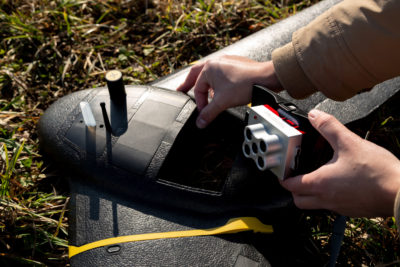
senseFly’s dual solution for efficient, in-depth crop analysis—the senseFly eBee X with MicaSense RedEdge-MX.
Our reseller network is also a cornerstone to our success. The amount of dedication and industry knowledge our network has, with years of experience, makes a huge difference. The strategic partnerships we create and nurture are also a big factor. When companies like Trimble Agriculture are naming you as their fixed-wing mapping drone of choice, it speaks volumes for those investigating. Last but certainly not least is our top-level support. We’re always striving to meet the customers’ needs in all facets.
Most of our readers are familiar with Pix4D. Can you explain your relationship to them?
Pix4D, same as senseFly, is a part of the Parrot Group. We are sister companies and take advantage of that where it makes sense, for instance, integrating with our mission-planning software for seamless mission-to-processing workflows. Pix4D has an even larger suite of products now, including its latest Pix4D React, which helps our users find the end-to-end solutions they are looking for.
Shift focus to the company. How was 2019 for senseFly? Any surprises?
2019 was significant in many ways. It’s always exciting to take stock at the end of the year and reflect on how much was learned. Although not as exciting to report, I think it’s important to point out that we’re not stagnant as leaders; we are pushing harder and gaining more ground. Our leadership is seasoned, and we’re well-positioned to continue to build products and relationships that help us to remain the industry standard. The big splash was the Trimble Select partnership announcement. We made huge leaps in the waiver space with strong partners such as North Dakota State, Airbus Aerial, MAAP and State Farm. Adding to that momentum you should see more work being done with our partners at NCDOT, who are leading the way from their side. Also, tactical mapping was created by our partners at Tough Stump Technologies. For senseFly to be at or near the center of all these big happenings is very exciting and telling for where we’re headed.
Looking forward, what are you excited about for the company and/or market in general that you can share?
There is a lot to be excited about! senseFly as a company has been around for nearly ten years, which is a long time in drone years. While we’ve seen many of our competitors close shop, we’re still going strong. As a company, we’re going to continue focusing on improving the technology, the sensors and the software that all go into making the eBee X such a flagship product.
Best of luck to you! Thanks, Troy.
#####
[1] Tactical Air Control Party
[2] National Air Space