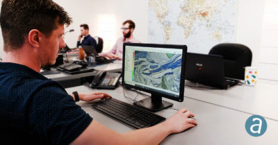
Thanks in no small part to drones, more and more professionals are becoming interested in photogrammetric data collection. For many, once data has been collected, the first hurdle involves processing it. For this installment of Quick-takes, we caught up with Phillipe Simard, PhD, President of SimActive, Inc. to address his company’s data processing solutions.
Phillipe, you’ve recently updated your flagship, Correlator3D. For anyone not familiar with this, who is it for and why do they need it?
Our Correlator3D™ product is a high-end photogrammetry software suite for processing imagery collected by drones, aircraft and satellites. It produces geospatial data such as point clouds, digital surface/terrain models, orthomosaics and 3D models. We have thousands of users in 100+ countries worldwide, which range from military agencies and government organizations to leading mapping companies. Examples of U.S. based clients include the US Army Corps of Engineers, the US Environmental Protection Agency, the National Geospatial-Intelligence Agency and Boeing Insitu to only name a few.
In June, SimActive announced a new drone data processing service based on Correlator3D™. Clients can upload full projects and have SimActive experts generate DSMs, DTMs, 3D models and orthomosaics.
What sets Correlator3D apart from other photogrammetry software?
Our Correlator3D software was originally designed to process large format imagery (250+ megapixels) collected by airborne platforms. Typical projects for such sensors comprise 20,000+ images, representing terabytes of data, which can be processed rapidly and in one single batch with our software. In the drone field, this provides us with a significant speed advantage of up to twenty times faster than other available tools. We also offer scripting and batch processing tools to elaborate custom photogrammetric workflows, as well as extensive manual capabilities to edit results to meet specific user requirements.
Are you seeing significant interest in multispectral imagery from your customers (and if so, where)?
We see a growing need for multispectral sensors for applications such as agriculture, to generate, for example, NDVI maps (normalized difference vegetation index). These sensors allow capturing image data at specific wavelengths across the electromagnetic spectrum and store them as different bands. Since individual bands are gathered at slightly different times during flight, they must be post-processed to be aligned with each other. Our new Correlator3D version 8.2 released earlier this year allows the user to register multispectral as well as infrared bands automatically. The resulting fused data can then be used in the software to produce multiband orthomosaics with perfect co-registration.
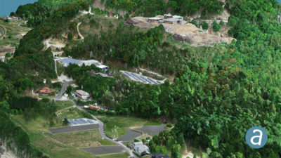
Correlator3D™ is being used in Japan for mapping projects acquired by the DJI Phantom 4 RTK.
We hear much about drone mapping these days. What portion of your customers are “new” to aerial imaging thanks to opportunities with UAS?
When drones started to appear in our market a few years ago, we originally thought that it would mainly be firms which were mapping with aircraft that would add drones to their toolkit. While some of them actually did, the great majority were companies completely new to airborne data capture. And we have experienced an exponentially growing number of users mainly because of these new players. What surprised us further is that quite a few of these new drone companies converted to larger format cameras flown on aircraft, to perform larger-scale projects. So we do feel that drones definitely helped in democratizing photogrammetry.
We see there’s a free trial download available. What can people do with the trial? Is it limited in functionality?
The free trial licenses that we provide are fully functional, with all modules and tools available. They allow new users to experience the software, and to evaluate the accuracy of results as well as processing times. The only limitation is that artifacts are introduced in less than 5% of the data. While this does not compromise the ability of users to take a purchase decision, our team can still offer to process sample data and deliver results completely free of charge.
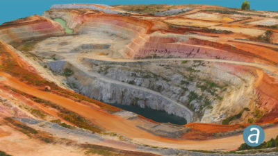
Correlator3D™ is being used for gold mining projects in Ivory Coast by Newcrest Mining Limited. SimActive software is employed to produce dense digital terrain models (DTMs) using small format digital cameras.
How is 2019 for SimActive? Any surprises?
The last few years, including 2019, have been very exciting for us. Drones have tremendously changed the photogrammetry industry, and we introduced new pricing for this new clientele. We now have a whole range of different options, from permanent licenses, to monthly and yearly options, with different license types based on the size of the sensors that our clients use. Our software can be used on different platforms, such as laptops directly in the field, standard PCs in the office and even cloud solutions such as AWS and Azure. We also recently introduced a unique processing service, where customers upload their dataset and our in-house experts produce optimal results and perform quality control.
Looking forward, what are you excited about for the company that you can share?
Our Correlator3D product has always been recognized for its speed, and we keep investing in R&D to further accelerate processing times. The team is currently working on an upcoming version that will enhance performance, which will reinforce our technological advance over competing tools. We expect that the need for processing larger projects will keep growing, and that the demand for a high-end solution like ours will also significantly increase.
Hopefully so! Thanks, Phillipe.