
Lewis Graham, President and CEO of GeoCue Group
Few technological processes have evolved as quickly as drone-based mapping—as a result, even fewer people can consistently predict where it’s all headed, fully grasping the impact unmanned sensors will have on mapping as we know it. Lewis Graham is one of those people. Most that know him will attribute his innate vision to a remarkable curiosity and deep knowledge of physics. But there’s more to it… One of the great GeoTech marvels of the last twenty years—a source of infinite value extraction—stems from the integration of imaging and location tech. Lewis, the former CEO of Z/I Imaging and developer of numerous mapping systems, has long occupied this intersection.
Editor’s note: For the charter installment of “State of the Art”, our new “quick-takes” department addressing key developments in geotechnology and the people behind them, we caught up with Lewis Graham, President and CEO of GeoCue Group, to gather his thoughts on the state of drone mapping. A PDF of this article is available here.
LIDAR Magazine (LM): Thanks for taking time to catch up with us, Lewis. You’ve been offering drone mapping solutions going on several years now. How has GeoCue’s product line evolved during that time?
Lewis Graham (LG): We first entered drone mapping around 2013 with the goal of opening a new market for our product, LP360. This desktop software is a good tool for processing point clouds derived from imagery as well as lidar data collected by drones.
We built a “foamy” fixed-wing drone equipped with a digital mirrorless prosumer camera (erroneously called a “digital, single lens reflex, DSLR”) for demonstrations and went on the road to visit a number of quarry sites in the eastern United States. Potential clients immediately understood the return on investment for routine but necessary operations such as stockpile volumetrics. However, they were hesitant about internalizing this new technology because of the perceived complexity and the then very complex 333 FAA rules. In response to this, we decided to stand up a small services group to ease customers into adopting drones for routine mapping. Since that time we have performed over 3,000 metric drone mapping operations. This has certainly been drone university for us!
Like many companies pursuing drone mapping solutions, we started with ground control points, located using static GNSS. Occupying each control point for 20 minutes was obviously a terrible approach so we soon found ourselves equipped with RTK survey kits. However, in many situations, laying out control points is just not an option due to safety and access constraints. This motivated us to develop on-board direct geopositioning systems which, in turn, led us down a long and arduous path of characterizing drone cameras and developing techniques for minimal control, high accuracy mapping. We reached the point where we could reliably achieve less than 4 cm vertical error with no control at all.
In 2014 we developed a multifrequency GNSS Post-Process Kinematic (PPK) direct geopositioning system for a multirotor mapping drone (based on the DJI S900) that we simultaneously developed. We started with RTK but soon realized that maintaining radio line of sight was a problem in low altitude flying and hence switched to PPK. We were using prosumer DSLR cameras on this system and achieved amazingly accurate results. So out of necessity, I found myself back in the hardware business!
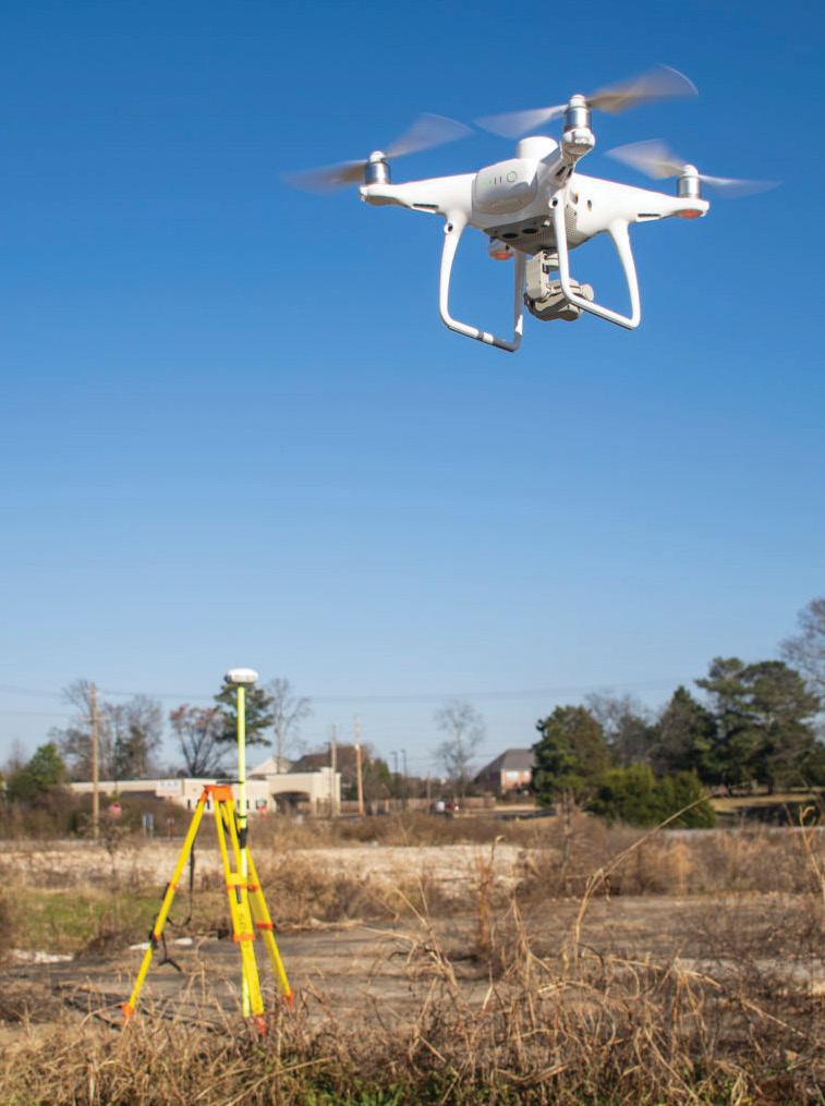
DJI Phantom RTK with Trimble GNSS base station.
In 2016 we set out to prove that accurate mapping could not be achieved with lower cost DJI drones using DJI cameras since we (like everyone else providing drone mapping technology) saw DJI as an existential threat to our business. We tested a few cameras with rolling shutters and, sure enough, the results were inaccurate and unpredictable. Then we tested DJI’s new (at that time) X4s camera that featured a mechanical shutter mode. Much to our surprise, no matter how hard we tried, we could not get bad results with this new camera! DJI soon followed with essentially the same camera on the Phantom 4 Pro. It was obvious that those who did not embrace DJI were going to have a tough row to hoe.
The only thing missing from the low end DJI solutions was direct geopositioning. We spent about 6 months figuring out how to synchronize our next generation PPK system with these drones in a non-invasive manner. This led to the development of Loki, our PPK solution for low end DJI drones as well as prosumer DSLR cameras.
We have now released our True View LIDAR/Camera imaging system. This is an integrated system of laser scanner and dual cameras that allows single pass collection of all of the data needed to produce a colorized point cloud as well as an orthophoto. We are also bundling in all of the software needed to process the raw data to finished products. We have even put a wrapper around POSPac, allowing this part of the post-processing flow to be integrated into our True View Evo software (a special version of LP360). Just last week we flew a small site for topographic analysis. From mission planning to delivering 1 ft contours was a total time of ½ day. This dramatic decrease in throughput time is a game changer.
LM: A game changer indeed! From which areas are you seeing the most interest?
LG: Our focus is on high accuracy mapping using rotary wing drones. This is an admittedly narrow area of the overall drone market. For example, a lot of experimentation is occurring in multispectral mapping, thermal imaging and other sensor payloads. While I am closely tracking these areas of drone mapping, we are sticking to the area where we have deep domain expertise.
There is still a lot of education to be done in high accuracy mapping. There is a school of thought amongst some practitioners that this work can only be performed by credentialed experts. We know that, other than proper FAA licensing (or equivalent outside the USA), any competent technician can learn to do high accuracy work. In fact, even very experienced persons such as those in my own company with a very long history in airborne photogrammetry are learning new things about these workflows every day.
The primary interest I am seeing now on the photogrammetry side is for minimal on-site time. Clients would like to show up on site, fly the drone, pack it up and leave. They would really like to remove additional steps such as setting base stations, laying out control and any other operation that adds time or complexity to the on-site portion of mapping. This is leading to a new interest in Virtual Reference Station (VRS) solutions when a local VRS network is available and Precise Point Positioning (PPP) solutions run in real time or post-processed mode for remote use.
Unfortunately, the same clients who want to go baseless want the highest accuracies! No matter what purveyors may advertise, PPP solutions are going to be hard pressed to consistently give results with better than around 6 cm root mean squared error (RMSE) in vertical. Most of our customers in the USA are shooting for the magical 1/10 foot (about 3 cm). So, again, we are faced with a lot of education about what is achievable using a specific type of technology. As a result, we are spending a considerable amount of time developing best practices for various mapping scenarios.
I believe that drone lidar is close to “crossing the chasm” in terms of customer acceptance. We started reselling lidar solutions from YellowScan (Montpellier, France) in 2018 to fill this gap in our offerings. Sites smaller than about 1,000 acres (400 hectares) are ideal for drone lidar rather than a manned aircraft system. These projects range from repetitive work such as open pit mine sites to time-limited new land development. Today’s topographic mapping is often performed with boots on the ground using GNSS rovers so the return on investment for drone lidar is immediately clear.
LM: Any exciting trends of note? Who’s “doing it right”?
LG: To me the big opportunity and challenge is the fact that the need for longer range lidar and positioning technology for vehicles (for both autonomous operations and automated safety systems) is driving an accelerated development of technologies. I visited the Consumer Electronics Show (CES) in January with the sole purpose of evaluating new trends in LIDAR technology. I talked with over 30 vendors and still did not cover all of the offerings. While most of what was on display was “vaporware”, the energy and money going into compact, long range lidar is going to result in revolutionary changes for drone mapping. For example, there are several companies offering doppler-enabled systems that can measure the relative speed between the vehicle and target. I am not sure how this might apply to our business area but I know someone will come up with a very clever use case.
We are within 12 months of having lidar systems with no moving parts (if we consider micro-electro-mechanical system, MEMS, components as non-moving). This is exciting because it promises to reduce both the mass (“weight”) of small lidar systems as well as their power requirements. I think we will soon see small lidar systems with true ranges (say from 10% reflective surfaces) of 250 meters. When you consider that the ubiquitous VLP-16 has a useful range of no more than 50m (though it advertises 100 m!), you can see what a game changer this will be. Several manufacturers are hedging their bets and looking at mapping as a secondary market to automotive. These vendors (for example, Cepton, LeiShen Intelligent System Co., Quanergy and others) recognize that features such as multiple return capability are a non-negotiable requirement for a mapping LIDAR and are addressing these auxiliary requirements.
The other very exciting thing I see happening is a very big push to reduce the cost and complexity of multifrequency GNSS receivers. There was an announcement by u-blox (a major GNSS supplier to the automotive industry) of a new multifrequency, multi-constellation GNSS chip set for around US $200. While several startups have attempted to build low cost GNSS capable of RTK/PPK centimeter-level performance, none have hit reliability sufficient for kinematic mapping. This new offering from u-blox is going to dramatically change this landscape. We will see complete base/rover kits for under US $2,000 within the year.
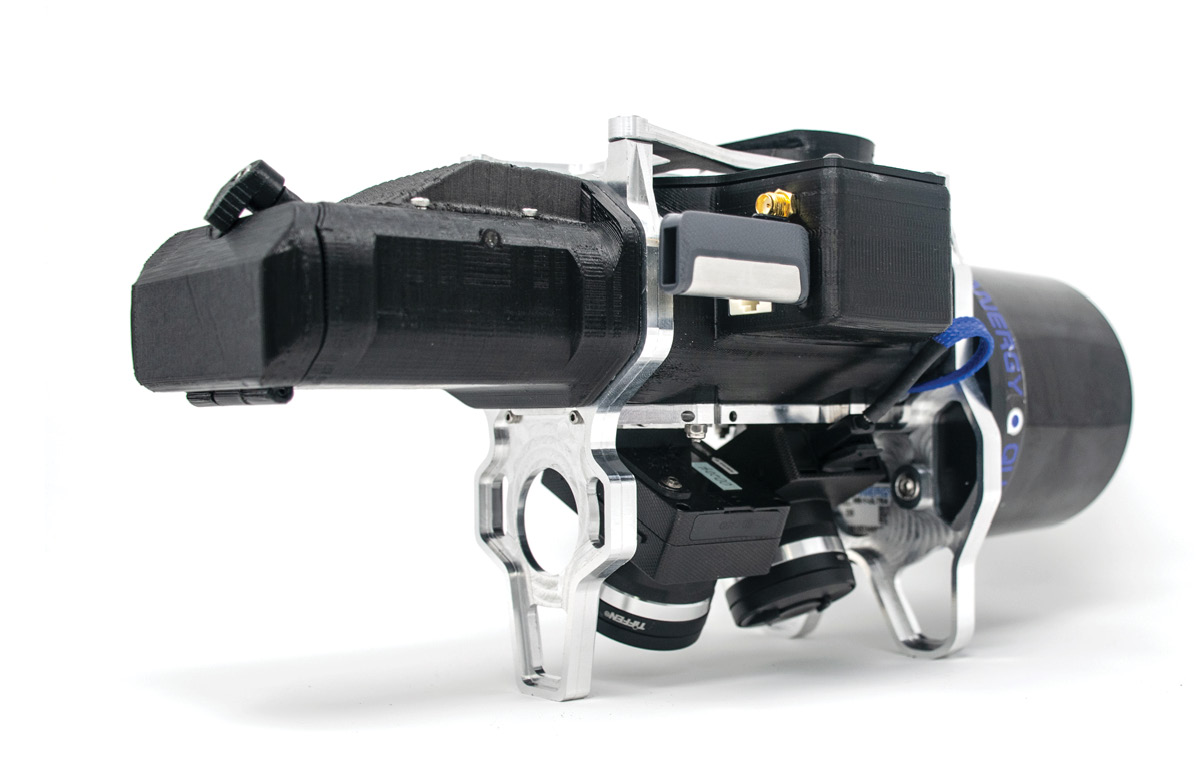
The True View 410, an integrated LIDAR/camera fusion platform. Available for standard purchase or use via subscription service.
Low cost inertial measurement systems (IMS) and Attitude, Heading Reference Systems (AHRS) are already available and are rapidly improving in accuracy/precision. Currently the most expensive support component in a drone lidar system, these systems are descending below US $3,000 for a unit with sufficient accuracy to be used in low altitude lidar. Right now Inertial Navigation System (INS) processing software remains the sole obstacle to a low cost position and orientation system (POS). I would guess that within this year, a project similar to RTKLib will evolve to address this gap.
Without a doubt, complete drone lidar systems will see an order of magnitude reduction in cost within the next two to three years. At that point, we will see fused imagery/ lidar as the standard for all drone mapping. Exciting times, indeed!
LM: Any ongoing challenges or concerns?
LG: As I have already mentioned, the biggest challenge I see right at the moment is effectively educating everyone involved in the drone mapping chain. End users of the products that can be produced from drone mapping platforms need to know how to select the technology appropriate for their requirements as well as have a fundamental understanding of accuracy and precision.
Service providers really need to understand how to use drone mapping systems (photogrammetric and lidar), the measures (pun intended) they need to take to achieve a target accuracy and how to achieve consistent results.
We all need to learn to speak in plain language so that all involved fully understand how to specify and respond to work. For example, most customers for stockpile inventory work want to speak of error in terms percentage or cubic meters/yards of error. They have a difficult time understanding how a specified vertical error expressed in RMSE relates to their needs (indeed, so do most providers of the service, for that matter!)
We are still in the early adopter phase of this business. We do not really know enough yet for anyone to have any significant “secret sauce” that provides some huge competitive advantage. We need to widely share information so that the ultimate buyers of this technology can feel comfortable in moving from their current solutions to ones deployed on drones.
Overall, I am very optimistic about the future of this business. We are in the midst of a revolution in how small mapping projects are performed and it is very exciting to be a part of the change.
LM: A revolution, indeed! Thanks again, Lewis.