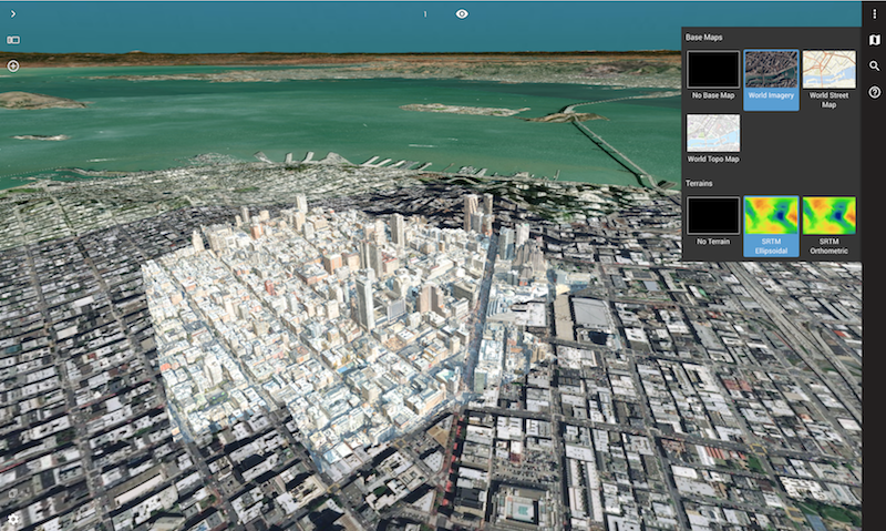
Portion of the San Francisco 3D Model © Geomni & nFrames, World Imagery WMS service © Esri, draped on global SRTM Terrain (open source).
Lokeren, Belgium, July 25th, 2019 – Orbit GT launches version 19.7 for its full 3D Mapping portfolio with some spectacular upgrades. At the same time, a new website is revealed.
“We’re proud of our fast update schedule, delivering new and enhanced features to our customers worldwide,” says Peter Bonne, CEO of Orbit GT. “The new orbitgt.com website provides our customers with more insight on solutions to their challenges and which software features can bring instant results.”
Version 19.7 includes :
- Introduction of new management console for 3DM Publisher
- Choice box for base maps and terrain (3DM Cloud)
- Usage of any Terrain file (3DM Cloud)
- Upload of City Model, Textured Mesh, Terrain, Resource enhancements such as Envelope, Thumbnail (3DM Cloud)
- Image and Resource Metadata display (3DM Cloud)
- Powerful support of vector data, including WFS services (3DM Cloud)
- Enhanced View Depth management (3DM Cloud)
- Enhanced Oblique data support (3DM Cloud)
- Smooth transition from Floor to Floor (3DM Cloud)
- Embedded Systems Requirements check (3DM Cloud)
- Maximize Single View (3DM Cloud)
- Enhanced E57 support (3DM Content Manager)
- Enhancements on Upload procedures and user feedback (3DM Content Manager)
- Enhancements on 3DM Cloud Console for data management
and a great number of updates and fixes.
About Orbit GeoSpatial Technologies
Orbit Geospatial Technologies is world leader in solutions for exploiting 3D Mapping content in managing, viewing, extracting, publishing, sharing and embedding in workflows, either desktop or cloud based. Orbit GT specializes in 3D Mapping solutions for Mobile Mapping, UAS Mapping, Indoor Mapping and Aerial Oblique Mapping, replacing the big data dilemma with ease of use. Orbit GT is headquartered in Lokeren, Belgium, and enjoys a global business network. As we experience many of Orbit GT customers are using several techniques of reality capture, such as Mobile Mapping, Terrestrial scanning, Aerial Oblique and UAS Mapping, we worked towards an integration of our portfolio to offer a single product line covering the needs for each of these domains. This native integration is a sure win for every customer and user.
