 Apr. 3rd, 2019 – VirtualGrid is pleased to announce the availability of VRMesh v10.3, the latest version of its powerful point cloud and mesh processing software. This release has added a new feature for water catchment analysis.
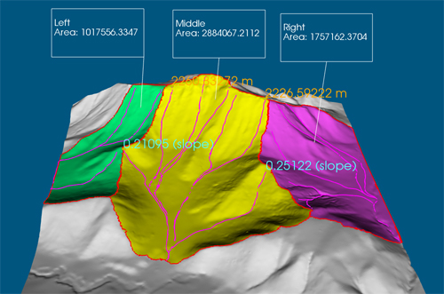
VRMesh provides a streamlined workflow covering everything from automatic point cloud classification to accurate point cloud meshing. Analyzing water catchment becomes easy based on a high-quality 3D terrain surface. The program can quickly calculate the direction water will flow, find catchment areas, trace water flow paths, extract catchment boundaries, as well as do some measurements, such as the length/average slope of a flow path and the area of a catchment. VRMesh provides detailed water flow information for realistic 3D hydrological modeling.
With these cutting-edge technologies, VRMesh becomes the most comprehensive point cloud and mesh processing software tool in current market. Our customers come from a wide range of industries, including land surveying, construction, transportation, energy, environment, mining, etc.
Please watch YouTube video: https://youtu.be/pbfA3JnaqKs
About VirtualGrid
VirtualGrid is the developer of VRMesh, an advanced 3D point cloud and mesh processing software tool. VRMesh can automatically process any point cloud generated from laser scanning or from photogrammetry. Please visit our website www.vrmesh.com for more information.
