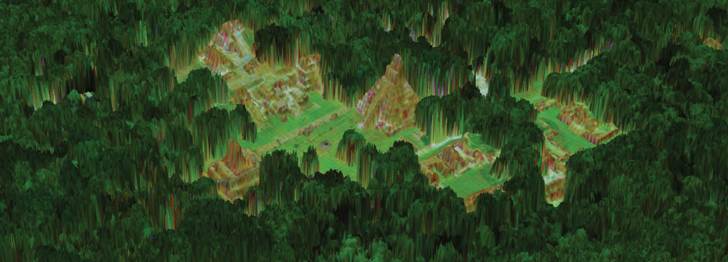
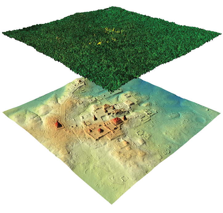
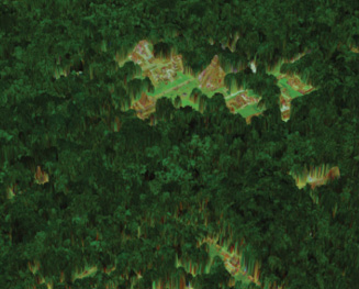
Multispectral lidar view of the grand plaza of the Maya city of Tikal in Guatemala. The 3D first-surface model was overlaid with a false-color multispectral lidar intensity image.
The rainforests in Central and South America give little indication of the civilizations that they’ve swallowed up. A few centuries ago these regions were home to bustling indigenous cities, yet when the civilizations collapsed or the settlements were abandoned, the forests quickly overran their buildings like a rolling green carpet. Now, we can see little of these structures except for the occasional pyramid poking out of the forest to indicate the location of what was once a sprawling metropolis. These forests have made it difficult for archaeologists to study the cities and the cultures that made them. Thankfully, the last two decades have given archaeologists an important new tool: airborne lidar.
Editor’s note: A PDF of this article as it appeared in the magazine is available HERE.
Removing the lidar returns that originated from the vegetation reveals human-made structures and topographic modification by the Maya.
Flying above the forest on an aircraft, lidar systems emit laser pulses to measure the elevation of the ground below and create detailed 3D maps of the terrain. This approach is significantly more productive and even more detailed than trying to survey from the ground. For example, at the Maya site of Caracol in Belize, it took archaeologists 20 years on foot to survey just nine square kilometers. Using airborne lidar, 200 square kilometers were mapped in as little as six days, with greater resolution than that accomplished on foot.
While ground surveys are ideal for documenting localized site details, airborne surveying provides the surveyor a much broader, yet detailed, perspective of the area. A walker may encounter a slight ridge in the earth and think nothing of it, but a lidar’s overhead view can identify that the ridge extends in a straight line for hundreds of meters and connects to other features.
The first commercial lidar sensors became available in the mid-1990s. Unlike traditional photographic sensors, airborne lidar had the unique capability to be used day or night, penetrate vegetation canopies and map underlying structures. Since then, significant improvements in technology have resulted in lidar becoming an essential exploratory tool for archaeologists worldwide. This article describes some of the key advances in airborne lidar sensors and how they have helped us map out the civilizations that once thrived centuries ago.
Humble beginnings
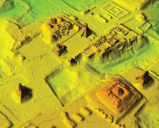
3D bare-earth perspective view of the core of Tikal, colored by the local slope.
The earliest use of lidar for archaeological purposes in South and Central America was almost serendipitous. In response to the devastation caused by Hurricane Mitch in Honduras in 1998, the Bureau of Economic Geology at the University of Texas used its then-new Optech ALTM 1225 airborne lidar in 2000 to derive accurate topographic maps that the United States Geological Survey (USGS) could develop into flood risk maps. As a side project, the Bureau wanted to collect some sample data to try different approaches to ground classification, and decided to do so at the nearby Maya site of Copan in western Honduras.
The ALTM 1225 was uniquely equipped for surveying in the rainforest. When a lidar fires its laser at a forest, some of the beam hits the thick canopy, some hits the lower branches, some hits the undergrowth, and finally (if the researcher is lucky) some of it reaches the forest floor. The lidar receives a distinct return pulse for each of these objects, but early lidar models recorded only the first return from the canopy for each laser pulse, which wasn’t very helpful for determining what was on the forest floor. By comparison, the ALTM 1225 had a capability, new at the time, to record both the first and the last return reflections. With careful data processing, the users could strip away the first returns from the canopy so that only the ones from the ground remained, giving them a view of the bare earth below.
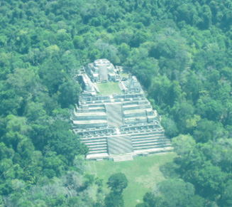
Oblique aerial photo of the Caana (sky-palace) pyramid at the Maya site of Caracol in Belize.
It is this ability that makes airborne lidar stand out from other wide-area surveying techniques such as photography and synthetic-aperture radar (SAR). Both of these techniques have their place in archaeology, but neither of them can easily penetrate through heavy canopies to survey the ground underneath. In Copan, the ALTM 1225 proved that airborne lidar could do what photography and SAR couldn’t: look through the rainforest at high resolution and bring to light the ruins that it’s been hiding for centuries.
Gathering speed
Still, it would be a few years before lidar would start turning heads in the Mesoamerican archaeological world. The technology and supporting software needed some refinement, and this came only came when the National Center for Airborne Laser Mapping (NCALM), which at the time was partially based at the University of Florida, made a survey in Belize. Unlike the survey of Copan, this one was intended to be an archaeological survey from the start. Moreover, NCALM was equipped with an Optech ALTM Gemini, which contained several years of upgrades over the ALTM 1225.
For example, the ALTM Gemini could fire more laser pulses per second (defined as its pulse repetition frequency or PRF), which greatly increases the chances of having laser pulses find holes in the thick rainforest. In all forests, a certain percentage of laser shots will be completely blocked by the foliage so that none of the laser energy reaches the ground and returns to the sensor at all. While temperate forests in places like California block 70-80% of laser shots, the thick rainforests in the tropics can often block up to 96% of them, leaving only a tiny fraction to hit the ground.

Four lidar data products from the Maya site of Copán in Honduras.
The ALTM 1225 had a PRF of 25 kHz so it fired about 25,000 shots per second, of which only a thousand or so actually reached the ground. That may sound like a lot, but it actually makes for very sparse data when the aircraft is moving quickly. An analyst may be able to pick out large features such as a grand temple or palace in such low-resolution datasets, but could easily miss smaller yet still significant features. By comparison, the Gemini’s maximum PRF was 166 kHz, six times faster than the ALTM 1225, so it could put several thousand points on the ground per second. This greatly improved the resolution and fidelity of the final maps, making it much easier to see the remains of small buildings.
Another crucial upgrade was the pulse width of the laser pulse, essentially a measure of how long the laser is firing each pulse. The longer the pulse width, the more difficult it is to distinguish between separate objects in the same pulse. For example, a lidar with a long pulse width might not be able to tell apart the return from a bush and the return from the ground beneath it, leading to an inaccurate measurement of the ground’s elevation. The older ALTM 1225 had a long pulse width that could only distinguish objects that were 5 meters apart, but the Gemini’s shorter pulse width let it distinguish objects that were 2–3 meters apart. This was very useful for surveying in parts of the rainforest with heavy undergrowth (which was pretty much all of it).
Searching for a lost city
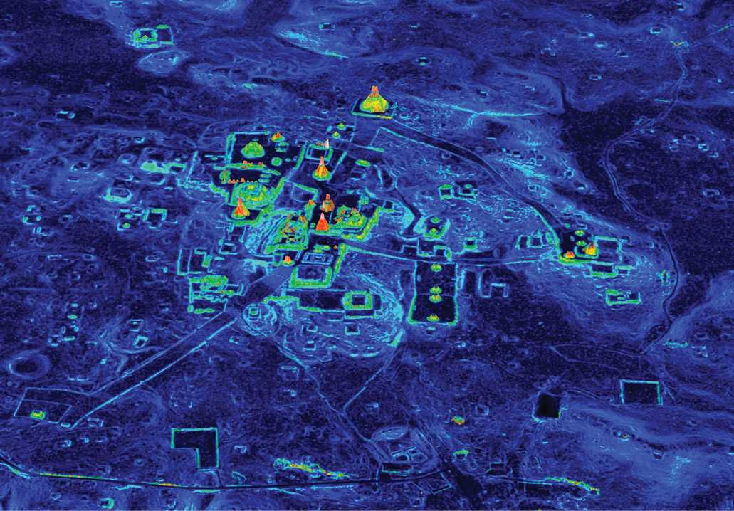
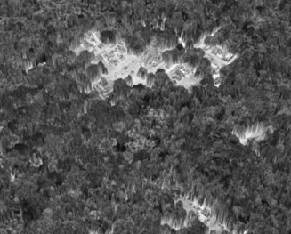
Lifting the canopy veil: Titan lidar data maps the forest canopy above Tikal and what is hidden beneath at an unprecedented level of detail.
NCALM’s excellent results with the survey of Caracol in Belize using the Gemini caught the eyes of many people involved in researching the ancient cultures of the Americas, which led to considerably more work in Belize and Mexico. One of the people interested in lidar was filmmaker and adventurer Steve Elkins, who had spent years trying to locate traces of a legendary “lost city” in north-eastern Honduras.
His proposal to NCALM was an interesting one: instead of surveying around pre-discovered ruins, could the Gemini search a wide area for ruins that researchers weren’t even sure existed? The land here is so remote and uninhabited that the rivers and mountains don’t even have names in the official maps. Such a shot in the dark would be almost impossible on foot (indeed, Elkins had tried to find the city for years that way). Intrigued and inspired by the challenge, NCALM, whose operational arm had recently moved to the University of Houston, took on the project.
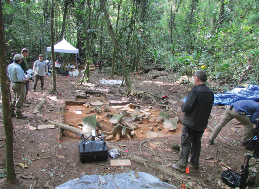
2016 excavation of stone artifacts found at one of the many lidar-identified sites in the Honduran Mosquitia.
Identifying a “lost city” within a large geographic area is a multivariable optimization problem that depends on the altitude, speed, and PRF of the lidar. On the one hand, the searchers wanted to cover the largest possible area in the least amount of time and cost, which required flying at a higher altitude with a faster airspeed and a higher PRF. However, their ability to obtain ground returns through the thick tropical canopies depended on two factors: a) being lucky enough to illuminate gaps in the canopy through which the laser energy can pass, and b) ensuring that the laser shots that go through the gap have sufficient optical energy that enough of their photons can make the return trip to the sensor and be recorded by the detector.
To increase the chances of putting laser pulses through gaps in the canopy, the searchers must increase the laser sampling, which means illuminating as much surface area as possible with laser footprints. They can accomplish this by flying higher (which increases the footprint size) and employing a higher PRF (which decreases the space between the footprints). Unfortunately, flying higher weakens the returning optical signal, making it harder to detect. Moreover, with the laser technology at the time, increasing the PRF would also reduce the energy packed in each laser pulse.
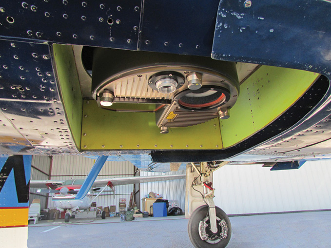
Sensor window of the Optech Titan multispectral lidar.
NCALM’s Gemini was at the time the best tool to overcome these challenges. Firstly, the Gemini was designed with a dual divergence mode, which enabled the operator to adjust the laser footprint size between two settings: Narrow and Wide. From a flying height of 1000 m, the footprint had a diameter of 25 cm in Narrow mode or 80 cm in Wide mode. Narrow mode allowed for a more precise height measurement at a lower surface illumination fraction, while Wide mode increased the surface illumination area for each footprint by a factor of 10, albeit at lower precision. Normally, Wide mode would also result in a weaker signal and lower power density. However, NCALM had had its Gemini customized years earlier to counteract this effect by boosting the laser power when it was in Wide mode. This allowed NCALM to achieve both a strong signal and large laser footprints, which was ideal for finding gaps in the dense tropical forest canopies.
After flying the same experimental test line at 600 m above the jungle’s canopy top repeatedly with varying PRF and divergence settings, NCALM determined that the Gemini detected and recorded the most ground returns when it was operated at 125 kHz with Wide divergence. This combination was the “sweet spot” between surface illumination and laser pulse energy, and NCALM used it to perform the entire survey.

Oblique aerial photo of the Grand Plaza in the Maya city of Tikal in Guatemala.
These technologies made the survey in Honduras quite successful, covering 140 square kilometers in only eight flights and revealing several small settlements composed of structures and plazas scattered here and there. Although this was not enough to count as an entire “lost city”, it was a larger habitation area than had been documented before in the neighbouring regions. Even to this day, very little is known about the people who inhabited this part of Honduras, so a team of archaeologists and a production crew from National Geographic set foot in the jungle to verify the apparent archaeological sites. On-site, they confirmed that the structures in the lidar data were indeed created by humans and discovered a large collection of carved stone objects which included metates (grinding stones) and vessels that were apparently left behind as offerings when the residents abandoned the sites.
Significant as this survey was, it was the next collaboration between NCALM and National Geographic that would create the biggest waves so far in both the media and the scientific community, and also showcase the abilities of the very latest lidar technology.
Seeing in color
A: The core of Tikal seen in Optech Titan multispectral lidar data: A) First-surface DSM colored with 1064-nm lidar intensities;
NCALM’s results had with the Gemini, along with its first survey using a new sensor in Guatemala in 2015, impressed the Pacunam Lidar Initiative, a joint effort of researchers from Guatemala and international institutions led by the Fundación Patrimonio Cultural y Natural Maya. Pacunam tasked NCALM with surveying a large portion of the Maya Biosphere Reserve in the northern region of Guatemala known as Petén, including the famous Maya city of Tikal. This area was truly gigantic, consisting of ten separate areas totalling 2100 km2, 15 times larger than the survey in Honduras.
By now, NCALM had a new lidar tool to tackle this challenge, the ALTM Titan. Teledyne Optech originally designed this next-generation lidar for NCALM to create high-density maps of land and shallow waters simultaneously, but its unique design made it shine in many other applications as well, including archaeology.
B: First-surface DSM colored with multispectral intensities (R: 1550 nm, G: 1064 nm, B 532 nm)
First of all, the Titan uses a total of three separate laser channels, each firing at up to 300 kHz. This lets it fire 900,000 times per second, over 5 times faster than the single-laser Gemini. In addition, each laser is set at different angle, with one pointing straight down, one pointing 3.5° forward, and one pointing 7° forward. These different angles improve the chances that part of a laser beam will slip through gaps in the foliage and reach the ground, resulting in fewer wasted canopy-only shots. Finally, the Titan’s pulse width is even shorter than the Gemini’s, letting it get valid ground returns from under vegetation as low as 1.5 meters.
The result of all this was high-resolution, high-fidelity maps that revealed over 60,000 human-made and human-modified structures, many of which were previously unknown to modern science. Some researchers estimate that this survey enabled the identification of about 80% of all the structures that have enough surface relief that they could possibly be found under the forest using lidar. Archaeologists can also now see subtle features such as canals, building foundations, small houses, and raised agricultural fields carved out of swampy areas, greatly improving their knowledge of the population that lived in the area.
C: Bare-earth DEM colored by elevation.
Laser design itself has also improved, with considerable benefits to the Titan’s efficiency. Because the Gemini’s laser tended to lose power when it was operating at its highest PRF, NCALM rarely used it at this setting for terrain mapping in dense jungle environments. To combat this effect, the Titan uses new lasers that do not suffer this drop-off, so it can use its maximum PRF without compromising the detection of faint ground returns. This enabled NCALM to cover 2100 km2 in the Maya Biosphere Reserve at 15 laser shots/m² with just eight flights.
The Titan’s most innovative feature, however, is that it can essentially see the ground in “color”. Most lidar systems use a single laser operating at a single wavelength, but each of the Titan’s three laser channels operates at a different wavelength: 532 nm, 1064 nm, and 1550 nm. This feature was primarily intended to help the Titan in its role as a topographic/bathymetric survey system (the 532-nm channel excels at surveying through water, while the others work best in surveys over land), but NCALM found an entirely different use for it.
All materials reflect light differently at different wavelengths, and that includes the three wavelengths used by the Titan. In other projects conducted by NCALM, false-color intensity maps have revealed the remains of ancient agricultural wetland fields where the topographic models just show flat terrain. This is possible because soils that had been irrigated in ancient time for agriculture still have different moisture levels from unirrigated land, and therefore show different responses at each wavelength.
Preserve and protect
These technical advances make airborne lidar systems an important tool for the identification and mapping of archaeological sites hidden beneath rainforests. Breakthroughs in archeological science have been the results of advances in lidar technology. While NCALM’s current schedule includes more surveys in Mexico, Guatemala, and Central America, the next big frontier is expected to be the Amazon. Large parts of this enormous rainforest remain uncharted, but modern airborne lidar systems such as the Titan are clearly the best tools to map it quickly and efficiently.
This is fortunate, because time is running out for these sites. Looking back at the areas surveyed in Honduras during the first airborne lidar survey in 2000, many sites have been overrun by new urban areas, cleared for cattle grazing, or turned into plantations of palm trees. As human populations expand, archaeologists and activists will have their hands full working to prevent further destruction of Central and South America’s cultural heritage, a task that should be made easier with a catalogue of sites made possible through airborne lidar and other technologies. In the end, these systems won’t just help find these sites, but also protect them.
Andrew Moller is a Technical Writer at Teledyne Optech, and has a degree in Classical Studies from the University of Waterloo.
Dr. Juan Carlos Fernandez-Diaz has been with The National Center for Airborne Laser Mapping (NCALM) since 2005 and has coordinated 18 archaeological lidar surveys totaling over 5600 km².