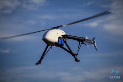
Broomfield, CO – (March 27, 2019)– Wohnrade Civil Engineers, Inc. (WCE), a full-service engineering firm recognized for precision aerial mapping and incorporating Unmanned Aerial Vehicles (UAV) high-resolution data into civil engineering design, announced today the addition of the Altus ORC2 electric helicopter (Figure 1) equipped with an advanced topographic LiDAR (Light Detection And Ranging) survey sensor to its extensive fleet of UAV engineering solutions. The 3-dimensional laser scans resulting from this technology enable WCE to deliver highly accurate, engineering-grade orthomosaic and topographic survey maps, even in mountainous regions or tracts covered with dense vegetation. The addition of the Altus ORC2 platform allows WCE to expand their UAV service offerings to a broad range of clients.
“We have been committed to delivering the most accurate data possible using the latest advances in UAV technology since purchasing our first drone in 2015,” says Mary Wohnrade, Principal Engineer, Wohnrade Civil Engineers, Inc.“LiDAR allows us to further enhance the accuracy of our geospatial mapping products while saving our clients both time and money. We can quickly certify the data collected and incorporate that mapping into final civil engineering designs allowing developers to optimize their investments while progressing their projects forward effectively and efficiently.”
LiDAR is an advanced survey method that uses light in the form of a pulsed laser to measures distance to the Earth. The resulting reflected pulses—combined with other data collected by the UAV—generate precise, three-dimensional maps (point clouds) of the shape of the Earth and its surface characteristics. The near-infrared laser used by WCE penetrates even the densest vegetation. And since each data point in a LiDAR point cloud has three-dimensional spatial coordinates (latitude, longitude, and height) it is highly effective in steep mountainous regions as well. The dataset created is in the standard ASPRS (American Society for Photogrammetry and Remote Sensing) LAS format compatible with any GIS or CAD software processing application.
Applications
Uses for WCE LiDAR-generated topographic maps include:
- Land development
- Floodplain analysis
- Stormwater management
- Water supply and quality monitoring
- Department of Transportation (DOT) route locations
- FEMA mapping and emergency response planning
- GIS (Geographic Information System) mapping
About Mary Wohnrade
Recognized as one of 2017’s Women to Watch in UASby Drone360 Magazine and Women and Drones, Wohnrade is a certified pilot and an FAA Section 333 Exemption Holder, as well as n FAA Part 107 Certified Operator. Since her introduction to UAS/UAV and precision aerial mapping in 2015, Mary Wohnrade and Wohnrade Civil Engineers have been at the forefront of developing precision aerial mapping, and then incorporating this mapping into civil engineering design. Only a handful of companies have demonstrated they are truly qualified to produce precision aerial mapping using UAV, and WCE is recognized as a member of this exclusive group.
Wohnrade Civil Engineering has also received national recognition of historic achievement as a result of their demonstration flight at the Great Sand Dunes National Park in October 2016. WCE collaborated with UAS Colorado, Black Swift Technologies, and the National Park Service to successfully map a 1-square mile area centered over the Star Dune, the tallest dune in the Park. In turn, WCE was recognized as the first FAA licensed operator to use a UAV to perform precision mapping in a National Park, an unparalleled achievement.
About Wohnrade Civil Engineering:
Wohnrade Civil Engineers, Inc. (WCE) is an FAA Section 333 Exemption Holder, as well as an FAA Part 107 Certified Operator. WCE is leading the way in both the development of precision aerial mapping, and incorporating UAV data into civil engineering design. They are one of a select few Engineering firms that performs the data collections, data processing, data post-processing, and finally, integrates UAV geospatial data into final civil engineering design. All their services are performed in-house using their experienced staff that is cross-trained in civil engineering, GIS, photogrammetry, UAV operations, and virtual reality. Their UAV workflow has been vetted by industry professionals and meets strict standards set by the American Society of Photogrammetry and Remote Sensing (ASPRS). WCE’s current fleet of UAVs include fixed wing aircraft, multi-rotor drones, and now a VTOL helicopter platform. More information on Wohnrade Civil Engineers, Inc. and their suite of UAV solutions can be found at: wcecivil.com or by calling (720) 259-0965.
