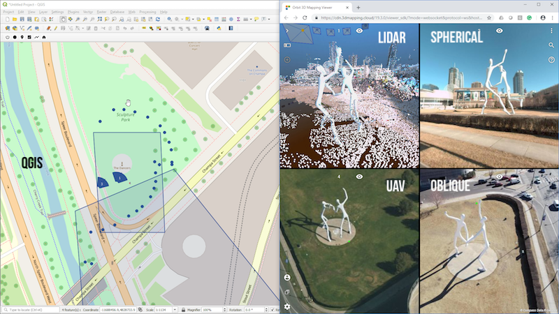
QGIS (left) and 3D Mapping Viewer Plugin (right) displaying LiDAR Point Cloud, Spherical, UAV and Oblique imagery of the same location. Data © CompassData, Denver.
Lokeren, Belgium, March 19th, 2019 – Orbit GT releases version 19.3 of its SDK for 3D Mapping Cloud and 3DM Publisher, and the Plugin for QGIS based on this same SDK.
“We’re happy to announce the release of our new SDK for viewing and integrating massive 3D Mapping content into any workflow“, says Peter Bonne, CEO of Orbit GT. “At the same time, a brand new QGIS plugin based on this new SDK is now available for download.”
The 3D Mapping Viewer SDK has gone through a significant upgrade. We’ve gone the extra mile to simplify the API while adding more functionalities. The SDK is free to use and can be downloaded from www.orbitgt.com – do register as Developer.
The SDK comes in 3 languages : JS, .Net and Python. The latter has been used to built the Plugin for QGIS. This Plugin is available for download today on www.orbitgt.com, for free !
About Orbit GeoSpatial Technologies
Orbit Geospatial Technologies is world leader in solutions for exploiting 3D Mapping content in managing, viewing, extracting, publishing, sharing and embedding in workflows, either desktop or cloud based. Orbit GT specializes in 3D Mapping solutions for Mobile Mapping, UAS Mapping, Indoor Mapping and Aerial Oblique Mapping, replacing the big data dilemma with ease of use. Orbit GT is headquartered in Lokeren, Belgium, and enjoys a global business network. As we experience many of Orbit GT customers are using several techniques of reality capture, such as Mobile Mapping, Terrestrial scanning, Aerial Oblique and UAS Mapping, we worked towards an integration of our portfolio to offer a single product line covering the needs for each of these domains. This native integration is a sure win for every customer and user.
