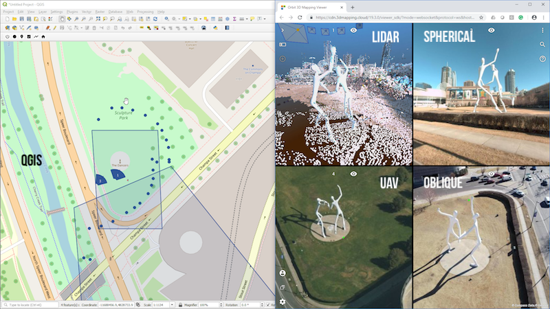
QGIS running Comsof Fiber with integrated Orbit 3D Mapping plugin © Comsof, Image-V.
Lokeren, Belgium, March 7st, 2019 – Orbit GT is joining Comsof to present at the FTTH Conference in Amsterdam, The Netherlands, Wed Mar 13th 2019.
“The FTTx and 5G market can boost their ROI significantly using Mobile Mapping in conjunction with Planning, Preparation and Roll-out of FTTx and 5G networks”, says Peter Bonne, CEO of Orbit GT. “We’re pleased we can join our partner Comsof, a Fiber network planning specialist and world leader, to show how Mobile Mapping can improve the Telco operators’ business with a perfectly integrated product offering.”
Comsof is highly respected in the FTTH market with its leading network planning software ‘FiberPlanIT’, recently rebranded to “Comsof Fiber”. Visit the Comsof booth S20 for our joint presentation on Network automation and mobile mapping, at 2pm on Wed Mar 13th 2019.
The image shows the integration of Comsof Fiber and Orbit GT’s 3D Mapping plugin for QGIS, displaying the planned Fiber network in a 3D view and Streetlevel-image view.
About Orbit GeoSpatial Technologies
Orbit Geospatial Technologies is world leader in solutions for exploiting 3D Mapping content in managing, viewing, extracting, publishing, sharing and embedding in workflows, either desktop or cloud based. Orbit GT specializes in 3D Mapping solutions for Mobile Mapping, UAS Mapping, Indoor Mapping and Aerial Oblique Mapping, replacing the big data dilemma with ease of use. Orbit GT is headquartered in Lokeren, Belgium, and enjoys a global business network.As we experience many of Orbit GT customers are using several techniques of reality capture, such as Mobile Mapping, Terrestrial scanning, Aerial Oblique and UAS Mapping, we worked towards an integration of our portfolio to offer a single product line covering the needs for each of these domains. This native integration is a sure win for every customer and user.
