 Leicestershire, UK, 28 February 2019 – 3D digital models derived from high resolution aerial photography are helping network operators plan the rollout of services including WISP (Fixed Wireless Access), 5G and Smart City applications. The work by Leeds based Wireless Coverage uses Digital Terrain and Surface (DTM / DSM) models. Derived from Bluesky’s aerial photography, the models are used within Wireless Coverage’s WISDM software which uses GPU Acceleration technology to create dynamic coverage maps. These maps are already being used to help operators plan network infrastructure, undertake property level look-ups and conduct marketing campaigns.
“Recent jumps in wireless technology allow huge uplifts in speed of data access and, in the UK alone, it is estimated that over 200,000 new small cell sites will be required to service the increase in data demand and new applications such as autonomous vehicles,” commented David Burns, founder of Wireless Coverage, the Chairman of the UK Wireless Internet Service Providers Association (UKWISPA) and an active member of 5GUK.
“Conventional planning tools are not designed for 5G and the very high frequencies in which it operates. These super high – millimetre-wave – frequencies are extremely susceptible to obstructions, such as buildings and trees, so highly accurate data and more precise planning systems are required to deliver reliable services,” he continued. “Bluesky’s national coverage of high resolution terrain and surface data, together with our WISDM solution, combine to solve this problem.”
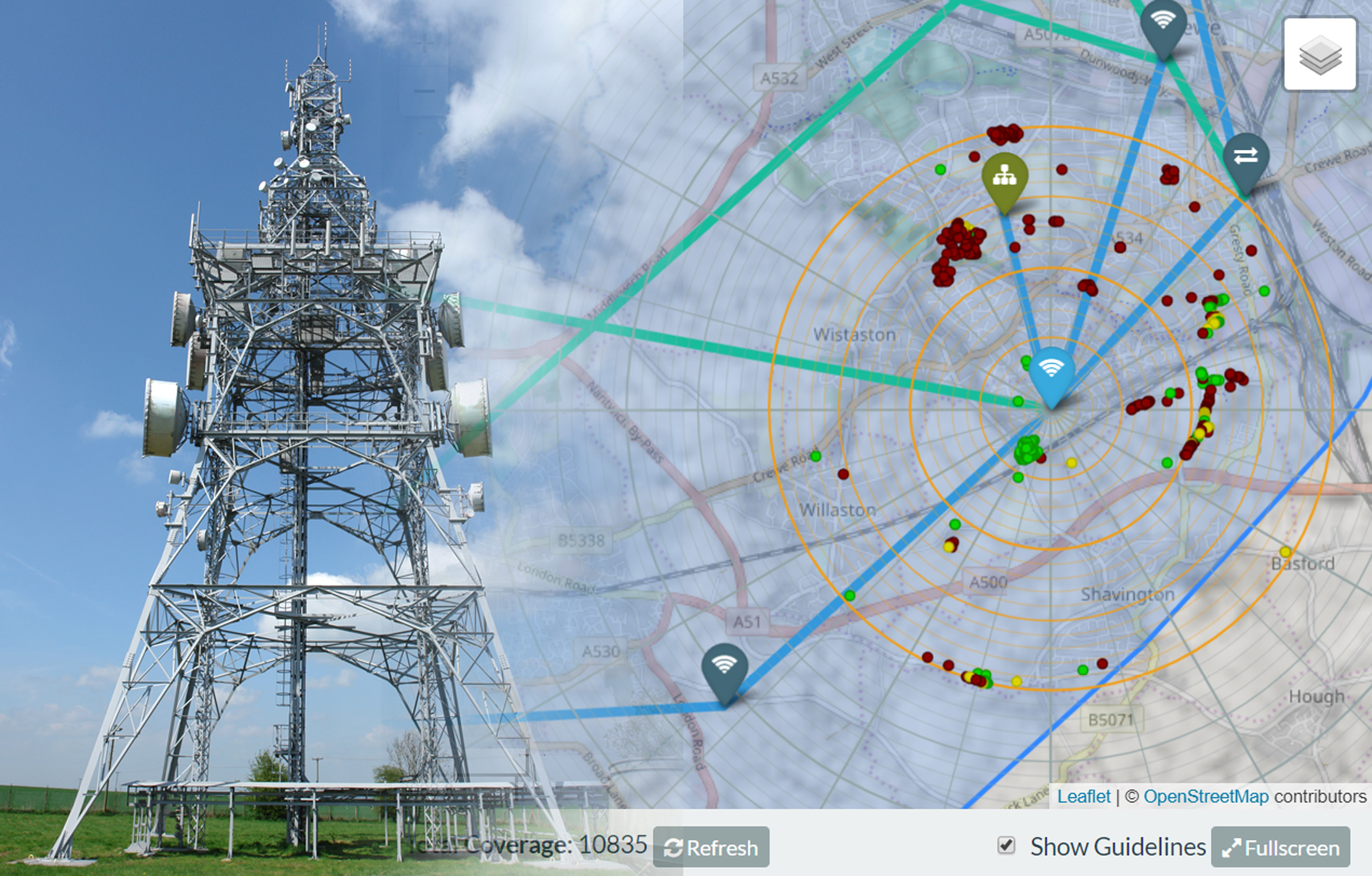
Wireless Coverage has successfully implemented the massive scale and performance of wireless-optimised GPU (Graphics Processing Unit) technology into wireless design. WISDM can perform billions of wireless line of sight calculations per second, meaning that large areas can be modelled, in high resolution, in real time. Using WISDM network operators can produce dynamic, scalable coverage maps based on the terrain and surface obstructions detailed within the Bluesky data, and the propagation patterns of access points.
Site planning functionality within WIDSM allows assessment of backhaul from other sites and an understanding of which properties can be served and advanced modelling features allow testing of different locations and antenna heights. WISDM can also be used to find intermediate locations to bridge existing towers or customers.
“Bluesky’s unique and highly accurate DTM and DSM’s enable the power of WIDSM to be unlocked,” concluded Burns. “For the first time, network planners can design wide-area Radio Access Networks using data resolutions of 50 cm, in real-time. This speeds up the design process, allows changes to be accommodated instantly and reduces coverage risks compared to conventional solutions.”
About Bluesky
Bluesky is a specialist in aerial survey including aerial photography, LiDAR and thermal data, using the very latest survey technology, including two UltraCam Eagles and a Teledyne Optech Galaxy LiDAR system integrated with a PhaseOne camera and thermal sensor. An internationally recognised leader with projects extending around the globe, Bluesky is proud to work with prestigious organisations such as Google, the BBC and Government Agencies. Bluesky has unrivalled expertise in the creation of seamless, digital aerial photography and maintains national “off the shelf” coverage of aerial photography, DTM and DSM through an ongoing three-year update programme. By purchasing a world first sensor for the simultaneous capture of LiDAR, Thermal and Aerial Photography data, Bluesky is in the enviable position of being able to provide customers with unique and cost effective solutions. Bluesky is leading the way in developing innovative solutions for environmental applications, including the UK’s first National Tree Map (NTM), solar mapping and citywide ‘heat loss’ maps and is currently developing noise and air quality mapping products. Bluesky is also the first company to offer CityMapper (simultaneously captured vertical, oblique and LiDAR) data in the UK. https://www.bluesky-world.com/
