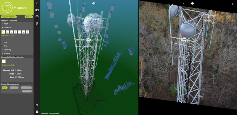
Example Cell Tower with measured length © Michael Baker Int’l, USA.
Lokeren, Belgium, February 15th, 2019 – Orbit GT supports all types of UAV imagery in its desktop products and SaaS product 3dmapping.cloud.
“It’s great to announce that our latest releases support the various image content produced by UAVs”, says Peter Bonne, CEO of Orbit GT. “while mapping projects produce Nadir images, other projects like pole inspection produce front-facing or oblique imagery. All of these are now seamlessly integrated in our desktop and online portfolio.”
Whichever job you need to to, your drone data can be digested by all Orbit GT products. Use the Nadir imagery to go for mapping. Use forward-facing images or oblique images for inspection and observation projects. In both cases you can opt for dense matching to generate a point cloud or textured mesh. In every situation, details can be viewed, measured and extraction with the same ease of use.
When using 3dmapping.cloud, you can share with a customer or contractor in a single click!
Check out www.3dmapping.cloud
About Orbit GeoSpatial Technologies
Orbit Geospatial Technologies is world leader in solutions for exploiting 3D Mapping content in managing, viewing, extracting, publishing, sharing and embedding in workflows, either desktop or cloud based. Orbit GT specializes in 3D Mapping solutions for Mobile Mapping, UAS Mapping, Indoor Mapping and Aerial Oblique Mapping, replacing the big data dilemma with ease of use. Orbit GT is headquartered in Lokeren, Belgium, and enjoys a global business network. As we experience many of Orbit GT customers are using several techniques of reality capture, such as Mobile Mapping, Terrestrial scanning, Aerial Oblique and UAS Mapping, we worked towards an integration of our portfolio to offer a single product line covering the needs for each of these domains. This native integration is a sure win for every customer and user.
